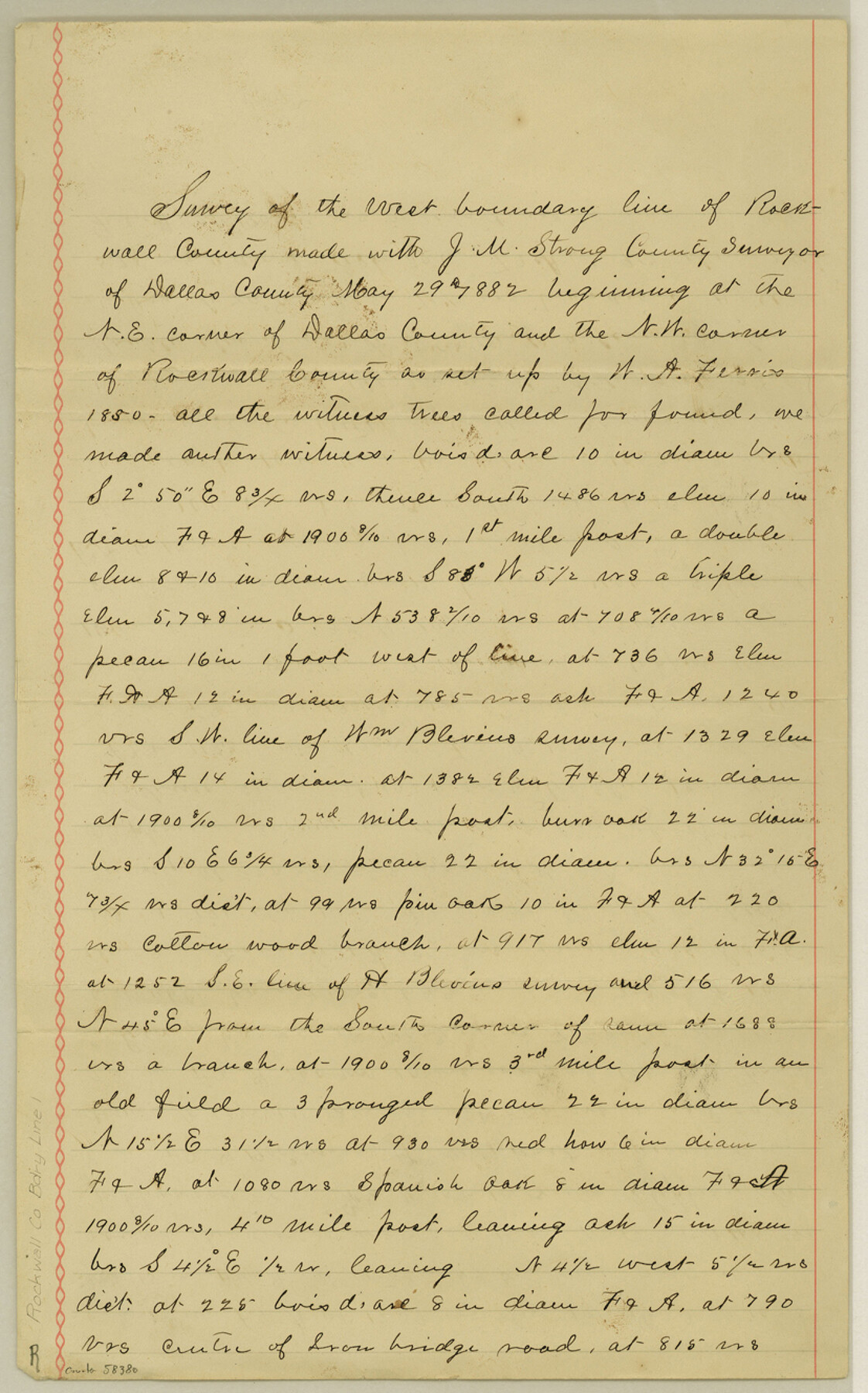
Rockwall County Boundary File 1
Field Notes of Co. Line between Dallas & Rockwall
-
Map/Doc
58380
-
Collection
General Map Collection
-
Counties
Rockwall
-
Subjects
County Boundaries
-
Height x Width
13.3 x 8.3 inches
33.8 x 21.1 cm
Part of: General Map Collection
Dickens County Working Sketch 13

Print $20.00
- Digital $50.00
Dickens County Working Sketch 13
1981
Size 26.8 x 21.4 inches
Map/Doc 68661
Fayette County Boundary File 5

Print $59.00
- Digital $50.00
Fayette County Boundary File 5
Size 14.4 x 9.0 inches
Map/Doc 53371
Kimble County Working Sketch 59

Print $20.00
- Digital $50.00
Kimble County Working Sketch 59
1963
Size 24.6 x 40.8 inches
Map/Doc 70127
Map of Texas and Pacific Ry. Company's Surveys in the 80 Mile Reserve

Print $40.00
- Digital $50.00
Map of Texas and Pacific Ry. Company's Surveys in the 80 Mile Reserve
1885
Size 41.5 x 91.8 inches
Map/Doc 60313
United States - Gulf Coast - Galveston to Rio Grande

Print $20.00
- Digital $50.00
United States - Gulf Coast - Galveston to Rio Grande
1919
Size 26.9 x 18.2 inches
Map/Doc 72743
Hardin County Sketch File 48

Print $20.00
- Digital $50.00
Hardin County Sketch File 48
Size 17.8 x 18.4 inches
Map/Doc 11634
Val Verde County Rolled Sketch 81

Print $20.00
- Digital $50.00
Val Verde County Rolled Sketch 81
Size 35.0 x 44.7 inches
Map/Doc 10088
Webb County Rolled Sketch 54

Print $20.00
- Digital $50.00
Webb County Rolled Sketch 54
1935
Size 24.7 x 18.8 inches
Map/Doc 8206
Controlled Mosaic by Jack Amman Photogrammetric Engineers, Inc - Sheet 28

Print $20.00
- Digital $50.00
Controlled Mosaic by Jack Amman Photogrammetric Engineers, Inc - Sheet 28
1954
Size 20.0 x 24.0 inches
Map/Doc 83479
Red River County

Print $20.00
- Digital $50.00
Red River County
1896
Size 24.3 x 21.5 inches
Map/Doc 3977
McLennan County Working Sketch 8

Print $20.00
- Digital $50.00
McLennan County Working Sketch 8
1974
Size 34.1 x 30.6 inches
Map/Doc 70701
Jim Hogg County Rolled Sketch EJF

Print $20.00
- Digital $50.00
Jim Hogg County Rolled Sketch EJF
1937
Size 36.0 x 32.4 inches
Map/Doc 9320
You may also like
Current Miscellaneous File 46

Print $4.00
- Digital $50.00
Current Miscellaneous File 46
1954
Size 10.7 x 8.2 inches
Map/Doc 73990
General Highway Map, Palo Pinto County, Texas

Print $20.00
General Highway Map, Palo Pinto County, Texas
1940
Size 18.2 x 24.6 inches
Map/Doc 79213
Flight Mission No. DAG-18K, Frame 182, Matagorda County

Print $20.00
- Digital $50.00
Flight Mission No. DAG-18K, Frame 182, Matagorda County
1952
Size 17.2 x 22.3 inches
Map/Doc 86374
Flight Mission No. CLL-1N, Frame 14, Willacy County

Print $20.00
- Digital $50.00
Flight Mission No. CLL-1N, Frame 14, Willacy County
1954
Size 18.2 x 22.1 inches
Map/Doc 87001
A Map of the United States of Mexico as organized and defined by the several Acts of the Congress of that Republic

Print $20.00
- Digital $50.00
A Map of the United States of Mexico as organized and defined by the several Acts of the Congress of that Republic
1846
Size 24.0 x 31.7 inches
Map/Doc 93760
Coke County Working Sketch 6

Print $20.00
- Digital $50.00
Coke County Working Sketch 6
1914
Size 19.1 x 15.7 inches
Map/Doc 68043
Polk County Sketch File 34

Print $20.00
- Digital $50.00
Polk County Sketch File 34
Size 16.9 x 18.2 inches
Map/Doc 12194
Aransas County Rolled Sketch 6

Print $20.00
- Digital $50.00
Aransas County Rolled Sketch 6
1953
Size 19.6 x 18.8 inches
Map/Doc 77190
Webb County Working Sketch 82

Print $40.00
- Digital $50.00
Webb County Working Sketch 82
1979
Size 32.9 x 62.9 inches
Map/Doc 72449
Carte du Mexique et de la Floride des Terres Angloises et des Isles Antilles du cours et des environs de la Riviere de Mississipi

Print $20.00
- Digital $50.00
Carte du Mexique et de la Floride des Terres Angloises et des Isles Antilles du cours et des environs de la Riviere de Mississipi
1703
Size 19.0 x 25.8 inches
Map/Doc 96519
Brewster County Rolled Sketch 114

Print $20.00
- Digital $50.00
Brewster County Rolled Sketch 114
1964
Size 17.3 x 11.4 inches
Map/Doc 5292
Ward County Working Sketch 37

Print $20.00
- Digital $50.00
Ward County Working Sketch 37
1969
Size 31.3 x 46.9 inches
Map/Doc 72343