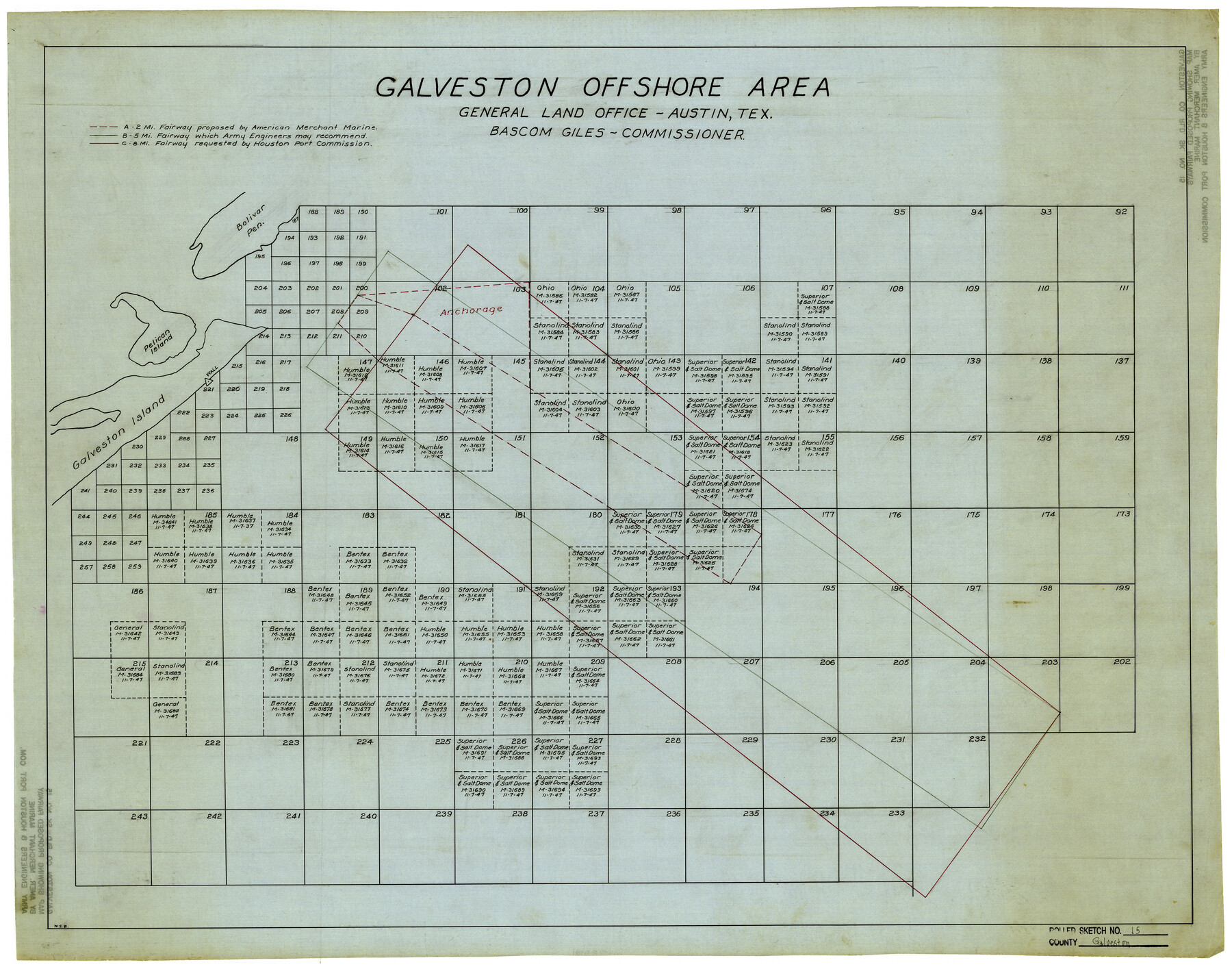
Galveston County Rolled Sketch 15
Galveston Offshore Area
-
Map/Doc
5954
-
Collection
General Map Collection
-
Counties
Galveston
-
Subjects
Surveying Rolled Sketch
-
Height x Width
24.7 x 31.2 inches
62.7 x 79.3 cm
-
Medium
linen, manuscript
Part of: General Map Collection
Montague County Working Sketch 45

Print $20.00
- Digital $50.00
Montague County Working Sketch 45
2013
Size 17.0 x 24.0 inches
Map/Doc 93649
Concho County Rolled Sketch 14

Print $20.00
- Digital $50.00
Concho County Rolled Sketch 14
1959
Size 29.9 x 31.2 inches
Map/Doc 8659

Matagorda County NRC Article 33.136 Sketch 11

Print $42.00
- Digital $50.00
Matagorda County NRC Article 33.136 Sketch 11
Size 18.0 x 24.0 inches
Map/Doc 94465
Dawson County Sketch File 11

Print $20.00
- Digital $50.00
Dawson County Sketch File 11
1927
Size 18.6 x 20.9 inches
Map/Doc 11293
Parker County Working Sketch 2

Print $20.00
- Digital $50.00
Parker County Working Sketch 2
1920
Map/Doc 71452
Flight Mission No. BQR-5K, Frame 68, Brazoria County

Print $20.00
- Digital $50.00
Flight Mission No. BQR-5K, Frame 68, Brazoria County
1952
Size 18.8 x 22.5 inches
Map/Doc 84013
Sutton County Sketch File 62

Print $4.00
- Digital $50.00
Sutton County Sketch File 62
1959
Size 3.7 x 8.6 inches
Map/Doc 37564
Pecos County Rolled Sketch 39A

Print $20.00
- Digital $50.00
Pecos County Rolled Sketch 39A
1908
Size 23.8 x 35.9 inches
Map/Doc 7218
Garza County Rolled Sketch 6D

Print $20.00
- Digital $50.00
Garza County Rolled Sketch 6D
1913
Size 17.4 x 16.0 inches
Map/Doc 5998
Carte du Spits-Berg, et partie de la Côte de Galles hams-kes au nouveau Groenland

Print $20.00
- Digital $50.00
Carte du Spits-Berg, et partie de la Côte de Galles hams-kes au nouveau Groenland
1782
Size 13.8 x 19.8 inches
Map/Doc 97123
Potter County Sketch File 2

Print $20.00
- Digital $50.00
Potter County Sketch File 2
1887
Size 29.3 x 39.4 inches
Map/Doc 10573
You may also like
Hall County Sketch File 2

Print $12.00
- Digital $50.00
Hall County Sketch File 2
1880
Size 17.1 x 8.4 inches
Map/Doc 42261
Bastrop County Boundary File 2

Print $12.00
- Digital $50.00
Bastrop County Boundary File 2
Size 9.1 x 6.9 inches
Map/Doc 50315
[Blocks K3, K4, K7, K8, K14, M7, east part of Leagues]
![90593, [Blocks K3, K4, K7, K8, K14, M7, east part of Leagues], Twichell Survey Records](https://historictexasmaps.com/wmedia_w700/maps/90593-1.tif.jpg)
Print $20.00
- Digital $50.00
[Blocks K3, K4, K7, K8, K14, M7, east part of Leagues]
Size 32.6 x 32.4 inches
Map/Doc 90593
Nueces County Rolled Sketch 60

Print $40.00
- Digital $50.00
Nueces County Rolled Sketch 60
Size 95.5 x 32.3 inches
Map/Doc 9607
Dimmit County Sketch File 56

Print $20.00
- Digital $50.00
Dimmit County Sketch File 56
1939
Size 15.8 x 27.4 inches
Map/Doc 11360
Navigation Maps of Gulf Intracoastal Waterway, Port Arthur to Brownsville, Texas

Print $4.00
- Digital $50.00
Navigation Maps of Gulf Intracoastal Waterway, Port Arthur to Brownsville, Texas
1951
Size 16.6 x 21.6 inches
Map/Doc 65422
[Blocks 34-36, Township 3N]
![92028, [Blocks 34-36, Township 3N], Twichell Survey Records](https://historictexasmaps.com/wmedia_w700/maps/92028-1.tif.jpg)
Print $20.00
- Digital $50.00
[Blocks 34-36, Township 3N]
Size 36.5 x 23.7 inches
Map/Doc 92028
Bexar County Sketch File 2

Print $4.00
- Digital $50.00
Bexar County Sketch File 2
1849
Size 9.1 x 8.3 inches
Map/Doc 14471
Aransas County NRC Article 33.136 Sketch 8

Print $22.00
- Digital $50.00
Aransas County NRC Article 33.136 Sketch 8
2007
Size 24.0 x 36.0 inches
Map/Doc 88800
Die Eisenbahm von dem Missisippi nach dem stillen Ocean (Californien)

Print $20.00
- Digital $50.00
Die Eisenbahm von dem Missisippi nach dem stillen Ocean (Californien)
1856
Size 14.0 x 14.8 inches
Map/Doc 94075
San Patricio County NRC Article 33.136 Sketch 4A

Print $3.00
- Digital $50.00
San Patricio County NRC Article 33.136 Sketch 4A
Size 17.0 x 11.0 inches
Map/Doc 94696
[Surveys along the Polk and Tyler County border]
![333, [Surveys along the Polk and Tyler County border], General Map Collection](https://historictexasmaps.com/wmedia_w700/maps/333.tif.jpg)
Print $2.00
- Digital $50.00
[Surveys along the Polk and Tyler County border]
Size 9.3 x 6.0 inches
Map/Doc 333