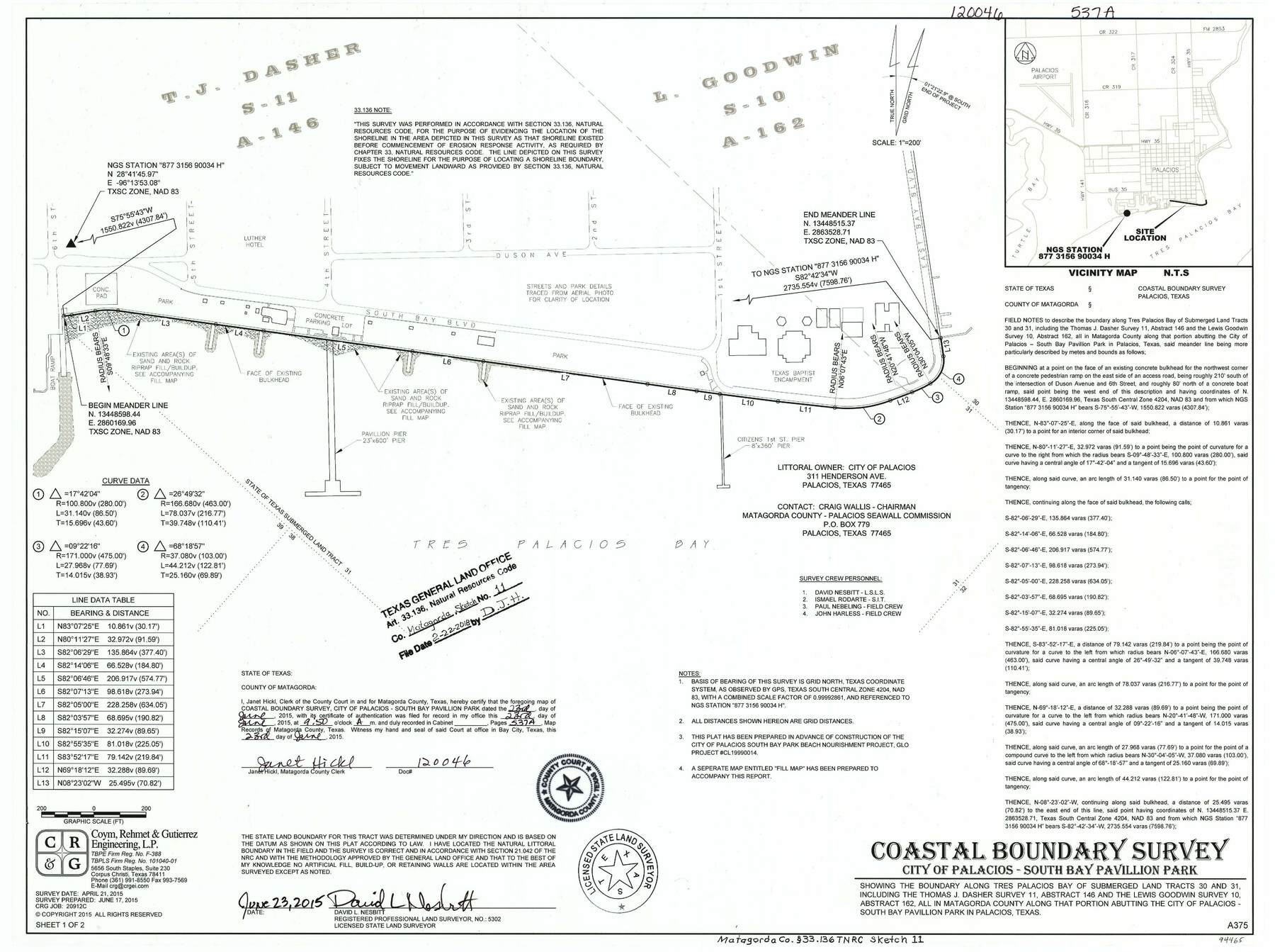
Matagorda County NRC Article 33.136 Sketch 11
Coastal Boundary Survey, City of Palacios - South Bay Pavilion Park Beach Nourishment
-
Map/Doc
94465
-
Collection
General Map Collection
-
Object Dates
2018/2/22 (File Date)
2015/6/17 (Survey Date)
-
People and Organizations
David L. Nesbitt (Surveyor/Engineer)
-
Counties
Matagorda
-
Subjects
Surveying CBS
-
Height x Width
18.0 x 24.0 inches
45.7 x 61.0 cm
-
Medium
multi-page, multi-format
-
Comments
Project: City of Palacios - South Bay Pavilion Park Beach Nourishment Project No.: CL19990014 (GLO)
Part of: General Map Collection
Live Oak County

Print $40.00
- Digital $50.00
Live Oak County
1899
Size 52.1 x 37.5 inches
Map/Doc 78423
Harrison County Working Sketch Graphic Index

Print $20.00
- Digital $50.00
Harrison County Working Sketch Graphic Index
1920
Size 44.9 x 41.7 inches
Map/Doc 76570
Real County Working Sketch 28

Print $20.00
- Digital $50.00
Real County Working Sketch 28
1947
Size 15.7 x 28.3 inches
Map/Doc 71920
Travis County Appraisal District Plat Map 4_1301

Print $20.00
- Digital $50.00
Travis County Appraisal District Plat Map 4_1301
Size 21.5 x 26.4 inches
Map/Doc 94213
Jim Hogg County Rolled Sketch 9

Print $20.00
- Digital $50.00
Jim Hogg County Rolled Sketch 9
1974
Size 18.2 x 19.8 inches
Map/Doc 6443
Webb County Rolled Sketch 76

Print $20.00
- Digital $50.00
Webb County Rolled Sketch 76
1959
Size 32.8 x 44.0 inches
Map/Doc 10133
Johnson County Working Sketch 35

Print $20.00
- Digital $50.00
Johnson County Working Sketch 35
2009
Size 23.2 x 28.6 inches
Map/Doc 89043
Coryell County Working Sketch 32

Print $20.00
- Digital $50.00
Coryell County Working Sketch 32
2022
Size 25.3 x 36.9 inches
Map/Doc 96966
Stonewall County Rolled Sketch 31

Print $20.00
- Digital $50.00
Stonewall County Rolled Sketch 31
1982
Size 25.6 x 42.9 inches
Map/Doc 7875
Brooks County Rolled Sketch 20

Print $20.00
- Digital $50.00
Brooks County Rolled Sketch 20
1943
Size 27.0 x 26.4 inches
Map/Doc 5342
Nueces County Rolled Sketch 104A

Print $40.00
- Digital $50.00
Nueces County Rolled Sketch 104A
1975
Size 54.2 x 35.9 inches
Map/Doc 10293

You may also like
The Mercer Colony. January 20, 1843

Print $20.00
The Mercer Colony. January 20, 1843
2020
Size 16.2 x 21.7 inches
Map/Doc 96360
San Saba County

Print $20.00
- Digital $50.00
San Saba County
1918
Size 46.8 x 41.2 inches
Map/Doc 63022
Terrell County Sketch File 8

Print $6.00
- Digital $50.00
Terrell County Sketch File 8
Size 11.4 x 10.2 inches
Map/Doc 37902
Jim Wells Co.

Print $20.00
- Digital $50.00
Jim Wells Co.
1966
Size 42.7 x 31.0 inches
Map/Doc 73198
Val Verde County Working Sketch 57

Print $20.00
- Digital $50.00
Val Verde County Working Sketch 57
1958
Size 29.2 x 31.0 inches
Map/Doc 72192
Kendall County Working Sketch 20

Print $20.00
- Digital $50.00
Kendall County Working Sketch 20
1970
Size 37.7 x 44.8 inches
Map/Doc 66692
Sutton County Sketch File 11

Print $10.00
- Digital $50.00
Sutton County Sketch File 11
1898
Size 14.2 x 8.8 inches
Map/Doc 37374
Gillespie County Working Sketch 2

Print $20.00
- Digital $50.00
Gillespie County Working Sketch 2
1958
Size 35.9 x 26.0 inches
Map/Doc 63165
Houston County Sketch File 38

Print $8.00
- Digital $50.00
Houston County Sketch File 38
Size 12.8 x 8.3 inches
Map/Doc 26821
Go Turnpike! Dallas-Fort Worth Turnpike (Recto)

Go Turnpike! Dallas-Fort Worth Turnpike (Recto)
1963
Size 11.2 x 17.2 inches
Map/Doc 94177
Webb County Working Sketch 55

Print $40.00
- Digital $50.00
Webb County Working Sketch 55
1955
Size 15.9 x 53.2 inches
Map/Doc 72421
Bailey County

Print $40.00
- Digital $50.00
Bailey County
1956
Size 49.4 x 31.4 inches
Map/Doc 95423