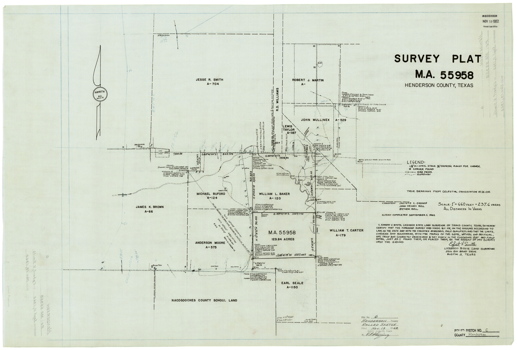
Henderson County Rolled Sketch 6
Survey plat MA-55958, Henderson County, Texas
-
Map/Doc
6202
-
Collection
General Map Collection
-
Object Dates
9/11/1962 (Creation Date)
11/19/1962 (File Date)
-
People and Organizations
Egbert V. Smith (Surveyor/Engineer)
Jacinto C. Orosco (Chainman/Field Personnel)
John Henry Bell (Chainman/Field Personnel)
Zether Bell (Chainman/Field Personnel)
-
Counties
Henderson
-
Subjects
Surveying Rolled Sketch
-
Height x Width
23.4 x 34.8 inches
59.4 x 88.4 cm
-
Medium
linen, manuscript
-
Scale
1" = 237.6 varas
Part of: General Map Collection
Flight Mission No. DQN-6K, Frame 9, Calhoun County

Print $20.00
- Digital $50.00
Flight Mission No. DQN-6K, Frame 9, Calhoun County
1953
Size 18.5 x 22.1 inches
Map/Doc 84431
McMullen County Working Sketch 43

Print $20.00
- Digital $50.00
McMullen County Working Sketch 43
1980
Size 35.2 x 28.1 inches
Map/Doc 70744
Colorado County Sketch File 3b

Print $4.00
- Digital $50.00
Colorado County Sketch File 3b
Size 7.0 x 8.2 inches
Map/Doc 18913
Stephens County Working Sketch Graphic Index

Print $20.00
- Digital $50.00
Stephens County Working Sketch Graphic Index
1940
Size 41.1 x 39.4 inches
Map/Doc 76702
Harris County Rolled Sketch 88

Print $20.00
- Digital $50.00
Harris County Rolled Sketch 88
1937
Size 34.8 x 22.8 inches
Map/Doc 6127
Jack County Working Sketch 18

Print $20.00
- Digital $50.00
Jack County Working Sketch 18
1986
Size 29.8 x 35.5 inches
Map/Doc 66444
Galveston - Texas City, Texas

Galveston - Texas City, Texas
2008
Size 26.9 x 39.0 inches
Map/Doc 96858
Hale County Sketch File 16

Print $4.00
- Digital $50.00
Hale County Sketch File 16
1888
Size 12.8 x 8.2 inches
Map/Doc 24747
Flight Mission No. CGI-1N, Frame 141, Cameron County

Print $20.00
- Digital $50.00
Flight Mission No. CGI-1N, Frame 141, Cameron County
1955
Size 18.5 x 22.2 inches
Map/Doc 84497
Supreme Court of the United States, October Term, 1923, No. 15, Original - The State of Oklahoma, Complainant vs. The State of Texas, Defendant, The United States, Intervener; Report of Medial Line Survey

Print $28.00
- Digital $50.00
Supreme Court of the United States, October Term, 1923, No. 15, Original - The State of Oklahoma, Complainant vs. The State of Texas, Defendant, The United States, Intervener; Report of Medial Line Survey
1924
Size 5.9 x 9.1 inches
Map/Doc 3055
Bee County Sketch File 14

Print $40.00
- Digital $50.00
Bee County Sketch File 14
1878
Size 14.5 x 12.5 inches
Map/Doc 14297
Jackson County Sketch File 6a

Print $30.00
- Digital $50.00
Jackson County Sketch File 6a
1894
Size 13.6 x 8.8 inches
Map/Doc 27634
You may also like
Corpus Christi Harbor

Print $40.00
- Digital $50.00
Corpus Christi Harbor
1976
Size 37.1 x 51.5 inches
Map/Doc 73480
[Part of Block K4]
![90526, [Part of Block K4], Twichell Survey Records](https://historictexasmaps.com/wmedia_w700/maps/90526-1.tif.jpg)
Print $3.00
- Digital $50.00
[Part of Block K4]
Size 9.6 x 11.7 inches
Map/Doc 90526
Cass County Sketch File 22

Print $8.00
- Digital $50.00
Cass County Sketch File 22
1849
Size 12.8 x 7.8 inches
Map/Doc 17427
Reeves County Working Sketch 42

Print $20.00
- Digital $50.00
Reeves County Working Sketch 42
1973
Size 46.3 x 31.5 inches
Map/Doc 63485
Red River County Working Sketch 73

Print $20.00
- Digital $50.00
Red River County Working Sketch 73
1979
Size 17.0 x 19.2 inches
Map/Doc 72056
Aransas County NRC Article 33.136 Location Key Sheet

Print $20.00
- Digital $50.00
Aransas County NRC Article 33.136 Location Key Sheet
1979
Size 27.0 x 23.0 inches
Map/Doc 77006
[Panhandle Counties]
![92066, [Panhandle Counties], Twichell Survey Records](https://historictexasmaps.com/wmedia_w700/maps/92066-1.tif.jpg)
Print $2.00
- Digital $50.00
[Panhandle Counties]
1885
Size 12.6 x 8.9 inches
Map/Doc 92066
Hansford County

Print $20.00
- Digital $50.00
Hansford County
1932
Size 39.7 x 39.0 inches
Map/Doc 95519
Harris County Sketch File 66

Print $20.00
- Digital $50.00
Harris County Sketch File 66
Size 16.9 x 27.5 inches
Map/Doc 11661
Jackson County Boundary File 3

Print $10.00
- Digital $50.00
Jackson County Boundary File 3
Size 10.9 x 8.7 inches
Map/Doc 55455

Flight Mission No. DAG-22K, Frame 85, Matagorda County

Print $20.00
- Digital $50.00
Flight Mission No. DAG-22K, Frame 85, Matagorda County
1953
Size 15.7 x 15.4 inches
Map/Doc 86469