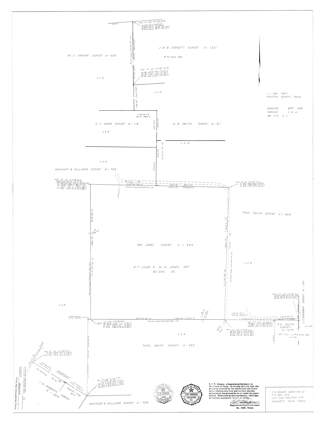
Houston County Rolled Sketch 11
[Sketch of Wm. Jones survey A-644 and surrounding area]
-
Map/Doc
6231
-
Collection
General Map Collection
-
Object Dates
1988 (Creation Date)
-
People and Organizations
C.R. Hodges (Surveyor/Engineer)
-
Counties
Houston
-
Subjects
Surveying Rolled Sketch
-
Height x Width
29.9 x 22.9 inches
75.9 x 58.2 cm
-
Scale
1" = 200 feet
Part of: General Map Collection
Bosque County Sketch File 29

Print $6.00
- Digital $50.00
Bosque County Sketch File 29
1863
Size 12.9 x 8.1 inches
Map/Doc 14816
Cherokee County Working Sketch 9

Print $20.00
- Digital $50.00
Cherokee County Working Sketch 9
1957
Size 46.9 x 34.0 inches
Map/Doc 67964
Map of Castro County

Print $20.00
- Digital $50.00
Map of Castro County
1900
Size 43.0 x 37.3 inches
Map/Doc 4906
Harbor of Brazos Santiago, Texas

Print $20.00
- Digital $50.00
Harbor of Brazos Santiago, Texas
1887
Size 27.1 x 18.3 inches
Map/Doc 72995
Cass County Working Sketch 4

Print $20.00
- Digital $50.00
Cass County Working Sketch 4
1936
Size 33.7 x 29.1 inches
Map/Doc 67907
Terrell County Sketch File 35

Print $36.00
- Digital $50.00
Terrell County Sketch File 35
1957
Size 32.0 x 37.6 inches
Map/Doc 10389
Baylor County Boundary File 5

Print $56.00
- Digital $50.00
Baylor County Boundary File 5
Size 8.1 x 62.3 inches
Map/Doc 50392

Colorado County Sketch File 21

Print $8.00
- Digital $50.00
Colorado County Sketch File 21
Size 13.1 x 8.8 inches
Map/Doc 18957
Webb County Boundary File 1a

Print $50.00
- Digital $50.00
Webb County Boundary File 1a
Size 14.3 x 9.0 inches
Map/Doc 59703
Goliad County Working Sketch 1

Print $20.00
- Digital $50.00
Goliad County Working Sketch 1
Size 23.7 x 39.9 inches
Map/Doc 63191
Galveston County Sketch File 61a

Print $12.00
- Digital $50.00
Galveston County Sketch File 61a
1988
Size 11.2 x 8.8 inches
Map/Doc 23665
You may also like
Atascosa County Working Sketch 19

Print $20.00
- Digital $50.00
Atascosa County Working Sketch 19
1952
Size 24.4 x 27.3 inches
Map/Doc 67215
Sutton County Working Sketch 17

Print $20.00
- Digital $50.00
Sutton County Working Sketch 17
1975
Size 34.0 x 27.2 inches
Map/Doc 62360
Bell County Sketch File 12a

Print $6.00
- Digital $50.00
Bell County Sketch File 12a
1853
Size 12.8 x 8.0 inches
Map/Doc 14387
Trinity County Sketch File 10

Print $8.00
- Digital $50.00
Trinity County Sketch File 10
1858
Size 13.1 x 8.0 inches
Map/Doc 38527
Fractional Township No. 1N and Township No. 2N R. No. 1E, Deaf Smith and Parmer Counties comprising Capitol Leagues 436, 437, 454, and 455 and parts of Capitol Leagues 433, 434, 435, 438, 453, 456, 457 and 458

Print $20.00
- Digital $50.00
Fractional Township No. 1N and Township No. 2N R. No. 1E, Deaf Smith and Parmer Counties comprising Capitol Leagues 436, 437, 454, and 455 and parts of Capitol Leagues 433, 434, 435, 438, 453, 456, 457 and 458
1906
Size 27.1 x 22.4 inches
Map/Doc 93965
Robertson County Sketch File 12

Print $18.00
Robertson County Sketch File 12
1987
Size 11.4 x 8.8 inches
Map/Doc 35404
[Lubbock, Crosby County Line]
![91323, [Lubbock, Crosby County Line], Twichell Survey Records](https://historictexasmaps.com/wmedia_w700/maps/91323-1.tif.jpg)
Print $2.00
- Digital $50.00
[Lubbock, Crosby County Line]
Size 9.2 x 14.7 inches
Map/Doc 91323
Gray County Working Sketch 1

Print $40.00
- Digital $50.00
Gray County Working Sketch 1
Size 121.0 x 38.8 inches
Map/Doc 63232
Presidio County Rolled Sketch SM

Print $15.00
- Digital $50.00
Presidio County Rolled Sketch SM
1910
Size 9.5 x 15.0 inches
Map/Doc 48822
Calcasieu Pass to Sabine Pass

Print $20.00
- Digital $50.00
Calcasieu Pass to Sabine Pass
1961
Size 44.6 x 35.7 inches
Map/Doc 69809
Flight Mission No. BQR-13K, Frame 120, Brazoria County

Print $20.00
- Digital $50.00
Flight Mission No. BQR-13K, Frame 120, Brazoria County
1952
Size 18.8 x 22.5 inches
Map/Doc 84081
Polk County Sketch File 44

Print $193.00
- Digital $50.00
Polk County Sketch File 44
1958
Size 9.4 x 11.0 inches
Map/Doc 34297