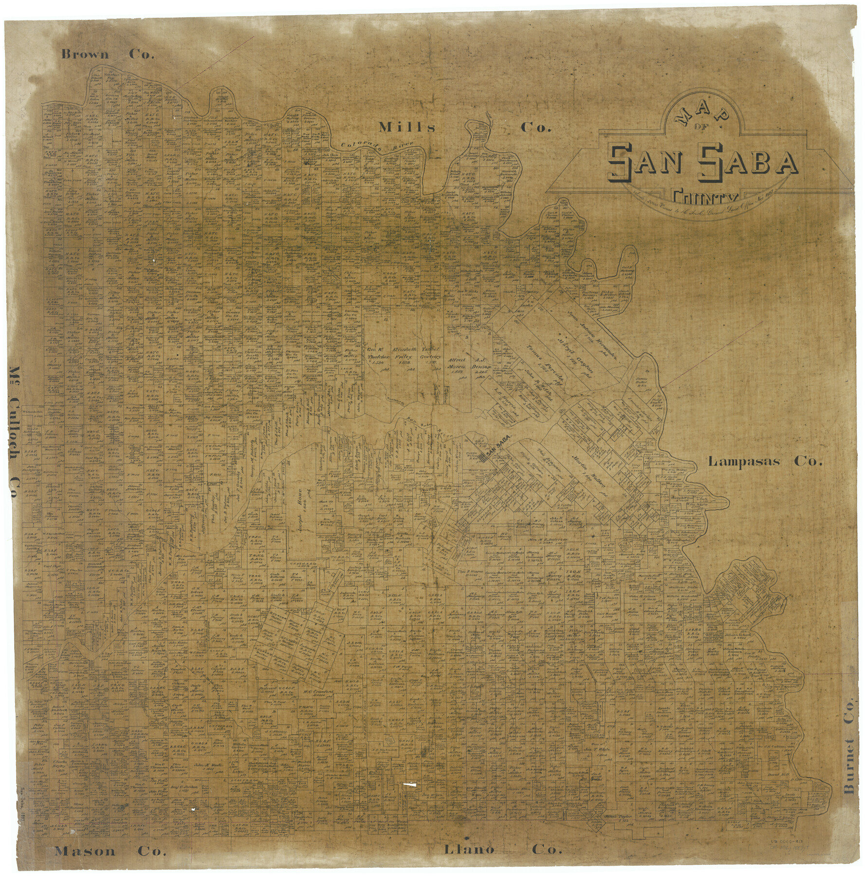
Map of San Saba County
-
Map/Doc
63020
-
Collection
General Map Collection
-
Object Dates
11/1887 (Creation Date)
-
People and Organizations
Texas General Land Office (Publisher)
-
Counties
San Saba
-
Subjects
County
-
Height x Width
41.7 x 41.7 inches
105.9 x 105.9 cm
Part of: General Map Collection
Bowie County Working Sketch 7

Print $20.00
- Digital $50.00
Bowie County Working Sketch 7
1933
Size 25.1 x 12.7 inches
Map/Doc 67411
Cass County Working Sketch 23

Print $40.00
- Digital $50.00
Cass County Working Sketch 23
1966
Size 56.8 x 37.1 inches
Map/Doc 67926
Victoria County Aerial Photograph Index Sheet 4

Print $20.00
- Digital $50.00
Victoria County Aerial Photograph Index Sheet 4
1953
Size 19.8 x 23.4 inches
Map/Doc 83748
Crockett County Rolled Sketch 76

Print $20.00
- Digital $50.00
Crockett County Rolled Sketch 76
1950
Size 24.6 x 26.1 inches
Map/Doc 5617
Comanche County

Print $20.00
- Digital $50.00
Comanche County
1944
Size 42.2 x 46.9 inches
Map/Doc 1807
Van Zandt County Sketch File 17 and 17a

Print $6.00
- Digital $50.00
Van Zandt County Sketch File 17 and 17a
1858
Size 14.2 x 8.1 inches
Map/Doc 39417
Galveston County NRC Article 33.136 Sketch 10

Print $48.00
- Digital $50.00
Galveston County NRC Article 33.136 Sketch 10
2000
Size 29.8 x 41.9 inches
Map/Doc 61592
Yoakum County Sketch File 1

Print $10.00
- Digital $50.00
Yoakum County Sketch File 1
Size 9.4 x 8.3 inches
Map/Doc 40697
Tarrant County Working Sketch 7

Print $40.00
- Digital $50.00
Tarrant County Working Sketch 7
1981
Size 18.9 x 54.3 inches
Map/Doc 62424
[Map of Starr County]
![4049, [Map of Starr County], General Map Collection](https://historictexasmaps.com/wmedia_w700/maps/4049.tif.jpg)
Print $20.00
- Digital $50.00
[Map of Starr County]
Size 18.8 x 16.2 inches
Map/Doc 4049
Houston County Working Sketch 19

Print $20.00
- Digital $50.00
Houston County Working Sketch 19
1976
Size 33.6 x 24.2 inches
Map/Doc 66249
Freestone County Working Sketch 15

Print $40.00
- Digital $50.00
Freestone County Working Sketch 15
1980
Size 56.5 x 33.7 inches
Map/Doc 69257
You may also like
Tom Green County Sketch File 63

Print $20.00
- Digital $50.00
Tom Green County Sketch File 63
1890
Size 31.8 x 17.9 inches
Map/Doc 12445
[Atchison, Topeka & Santa Fe from Paisano to south of Plata]
![64713, [Atchison, Topeka & Santa Fe from Paisano to south of Plata], General Map Collection](https://historictexasmaps.com/wmedia_w700/maps/64713-1.tif.jpg)
Print $40.00
- Digital $50.00
[Atchison, Topeka & Santa Fe from Paisano to south of Plata]
Size 32.2 x 116.3 inches
Map/Doc 64713
General Highway Map, McLennan County, Texas

Print $20.00
General Highway Map, McLennan County, Texas
1940
Size 18.3 x 24.6 inches
Map/Doc 79191
Galveston County Rolled Sketch 44

Print $2.00
- Digital $50.00
Galveston County Rolled Sketch 44
Size 17.6 x 11.3 inches
Map/Doc 5976
Map of Augustine Cty.

Print $20.00
- Digital $50.00
Map of Augustine Cty.
1839
Size 22.9 x 14.6 inches
Map/Doc 165
Flight Mission No. DQN-3K, Frame 64, Calhoun County

Print $20.00
- Digital $50.00
Flight Mission No. DQN-3K, Frame 64, Calhoun County
1953
Size 16.2 x 16.1 inches
Map/Doc 84355
Flight Mission No. CRC-2R, Frame 120, Chambers County

Print $20.00
- Digital $50.00
Flight Mission No. CRC-2R, Frame 120, Chambers County
1956
Size 18.5 x 22.3 inches
Map/Doc 84744
Burnet County Sketch File 43

Print $8.00
- Digital $50.00
Burnet County Sketch File 43
1856
Size 9.4 x 6.0 inches
Map/Doc 16763
Flight Mission No. DQO-7K, Frame 78, Galveston County

Print $20.00
- Digital $50.00
Flight Mission No. DQO-7K, Frame 78, Galveston County
1952
Size 18.8 x 22.4 inches
Map/Doc 85105
Comal County Sketch File 9

Print $4.00
- Digital $50.00
Comal County Sketch File 9
1859
Size 13.6 x 8.5 inches
Map/Doc 19016
Collingsworth County

Print $20.00
- Digital $50.00
Collingsworth County
1899
Size 42.7 x 39.7 inches
Map/Doc 4915
Hill County Sketch file 28

Print $33.00
- Digital $50.00
Hill County Sketch file 28
1987
Size 11.3 x 8.9 inches
Map/Doc 26530