Galveston County NRC Article 33.136 Sketch 10
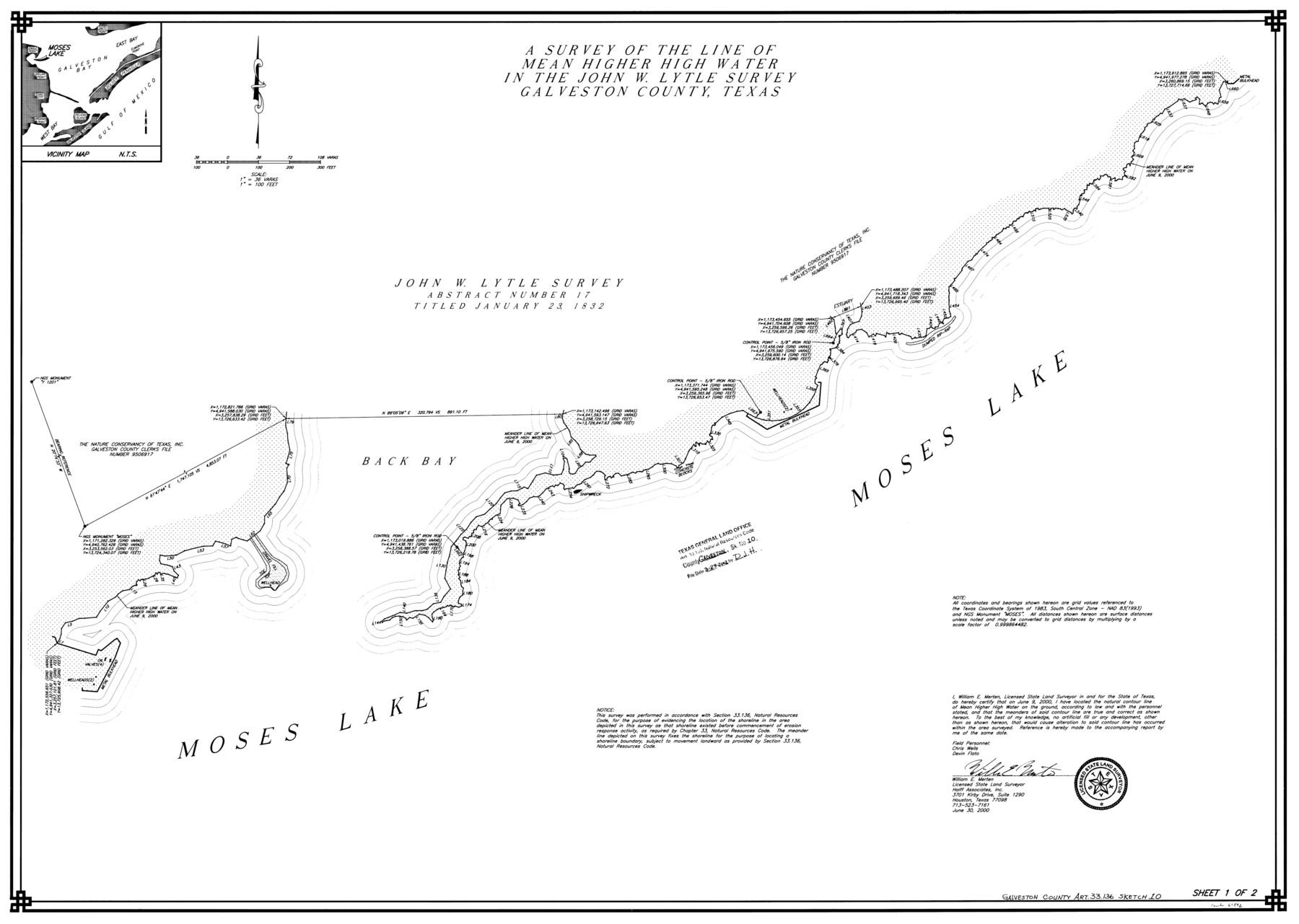
A Survey of the Line of Mean Higher High Water in the John W. Lytle Survey
Galveston County NRC Article 33-136 Report 4
-
Map/Doc
61592
-
Collection
General Map Collection
-
Object Dates
2000/6/30 (Creation Date)
2002/3/29 (File Date)
-
People and Organizations
Halff Associates (Publisher)
Halff Associates (Printer)
William E. Merten (Surveyor/Engineer)
-
Counties
Galveston
-
Subjects
Surveying CBS
-
Height x Width
29.8 x 41.9 inches
75.7 x 106.4 cm
-
Medium
multi-page, multi-format
-
Comments
Survey located about 13 miles North 42 degrees West of Galveston, Texas.
Part of: General Map Collection
Cameron County Sketch File 5

Print $4.00
- Digital $50.00
Cameron County Sketch File 5
1978
Size 11.1 x 8.7 inches
Map/Doc 17030
Karnes County Working Sketch 3

Print $20.00
- Digital $50.00
Karnes County Working Sketch 3
1943
Size 34.6 x 31.4 inches
Map/Doc 66651
Mills County Sketch File 1

Print $8.00
- Digital $50.00
Mills County Sketch File 1
1853
Size 11.6 x 12.7 inches
Map/Doc 31641
Map of Caldwell County, Land District since August 1st. 1859; Originally the part north, east of the line designated Bastrop - the balance, Gonzales Land District

Print $20.00
- Digital $50.00
Map of Caldwell County, Land District since August 1st. 1859; Originally the part north, east of the line designated Bastrop - the balance, Gonzales Land District
1861
Size 19.9 x 23.0 inches
Map/Doc 3355
Flight Mission No. BRA-8M, Frame 117, Jefferson County

Print $20.00
- Digital $50.00
Flight Mission No. BRA-8M, Frame 117, Jefferson County
1953
Size 18.5 x 22.3 inches
Map/Doc 85613
Shelby County Working Sketch 2

Print $20.00
- Digital $50.00
Shelby County Working Sketch 2
Size 32.9 x 37.3 inches
Map/Doc 63855

Real County Working Sketch 20

Print $20.00
- Digital $50.00
Real County Working Sketch 20
1944
Size 19.0 x 24.9 inches
Map/Doc 71912
St. Louis Southwestern Railway of Texas

Print $20.00
- Digital $50.00
St. Louis Southwestern Railway of Texas
1906
Size 21.4 x 30.0 inches
Map/Doc 64450
Map of Henderson County

Print $20.00
- Digital $50.00
Map of Henderson County
1877
Size 17.7 x 29.2 inches
Map/Doc 3666
Haskell County Rolled Sketch 3

Print $20.00
- Digital $50.00
Haskell County Rolled Sketch 3
1902
Size 18.1 x 21.0 inches
Map/Doc 6164
Sketch E No. 3 Shewing the progress of the Survey at North & South Edisto Rivers and St. Helena Sound, South Carolina

Print $20.00
- Digital $50.00
Sketch E No. 3 Shewing the progress of the Survey at North & South Edisto Rivers and St. Helena Sound, South Carolina
1852
Size 10.9 x 19.5 inches
Map/Doc 97215
You may also like

Nueces County Sketch File 85

Print $2.00
- Digital $50.00
Nueces County Sketch File 85
Size 11.0 x 8.5 inches
Map/Doc 82922
El Paso County Boundary File 22

Print $4.00
- Digital $50.00
El Paso County Boundary File 22
Size 13.6 x 8.6 inches
Map/Doc 53216
Collin County Boundary File 18b

Print $24.00
- Digital $50.00
Collin County Boundary File 18b
Size 12.7 x 8.1 inches
Map/Doc 51721
Liberty County Rolled Sketch H

Print $20.00
- Digital $50.00
Liberty County Rolled Sketch H
1943
Size 22.2 x 29.6 inches
Map/Doc 6623
Hansford County Working Sketch 3

Print $20.00
- Digital $50.00
Hansford County Working Sketch 3
1940
Size 20.5 x 16.5 inches
Map/Doc 63375
Ellis County Sketch File 1

Print $6.00
- Digital $50.00
Ellis County Sketch File 1
1849
Size 6.5 x 7.9 inches
Map/Doc 21824
Caney Cr. of East San Jacinto

Print $2.00
- Digital $50.00
Caney Cr. of East San Jacinto
Size 5.3 x 6.7 inches
Map/Doc 69745
El Paso Street and Vicinity Map (Verso)

El Paso Street and Vicinity Map (Verso)
1962
Size 18.3 x 30.8 inches
Map/Doc 94176
Webb County State Real Property Sketch 1

Print $40.00
- Digital $50.00
Webb County State Real Property Sketch 1
1985
Size 23.4 x 17.7 inches
Map/Doc 61664
Upton County Working Sketch 37

Print $20.00
- Digital $50.00
Upton County Working Sketch 37
1957
Size 41.1 x 36.9 inches
Map/Doc 69533
Flight Mission No. CRC-4R, Frame 180, Chambers County

Print $20.00
- Digital $50.00
Flight Mission No. CRC-4R, Frame 180, Chambers County
1956
Size 18.6 x 22.2 inches
Map/Doc 84931