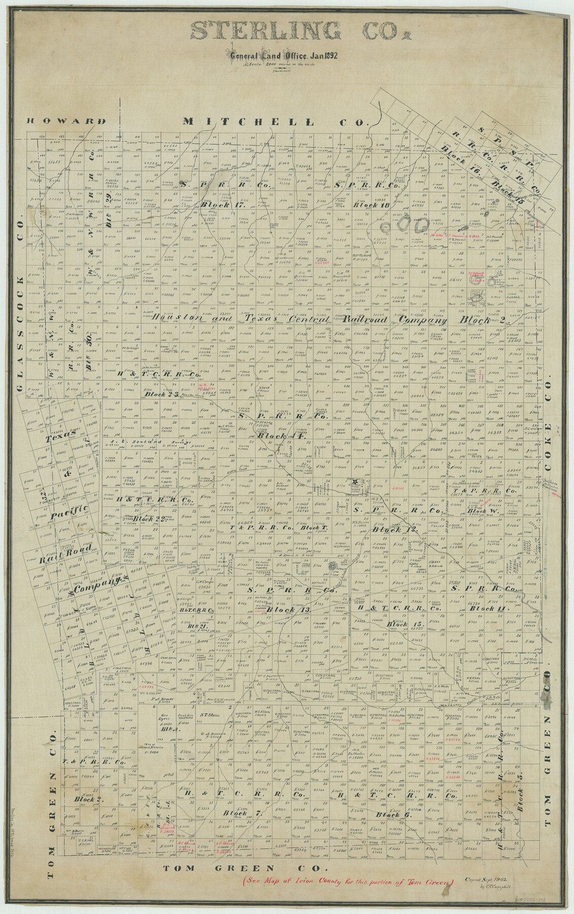
Sterling Co.
-
Map/Doc
63047
-
Collection
General Map Collection
-
Object Dates
1892 (Creation Date)
-
People and Organizations
Texas General Land Office (Publisher)
H.B. Hardeman (Draftsman)
H.B. Hardeman (Compiler)
-
Counties
Sterling
-
Subjects
County
-
Height x Width
45.5 x 28.6 inches
115.6 x 72.6 cm
-
Comments
Copied in September 1902 by C. C. Campbell.
Part of: General Map Collection

Northwest Part Pecos County

Print $20.00
- Digital $50.00
Northwest Part Pecos County
1975
Size 42.4 x 43.1 inches
Map/Doc 73261
Flight Mission No. DCL-7C, Frame 146, Kenedy County

Print $20.00
- Digital $50.00
Flight Mission No. DCL-7C, Frame 146, Kenedy County
1943
Size 18.8 x 22.4 inches
Map/Doc 86103
Mills County Working Sketch 21

Print $20.00
- Digital $50.00
Mills County Working Sketch 21
1981
Size 33.6 x 37.6 inches
Map/Doc 71051
Gulf Oil Corp. Fishgide - Port O'Connor

Gulf Oil Corp. Fishgide - Port O'Connor
1960
Size 12.2 x 22.3 inches
Map/Doc 75983
Irion County Rolled Sketch 4

Print $20.00
- Digital $50.00
Irion County Rolled Sketch 4
Size 25.6 x 36.4 inches
Map/Doc 6319
Ward County Rolled Sketch 26

Print $28.00
- Digital $50.00
Ward County Rolled Sketch 26
Size 9.9 x 15.0 inches
Map/Doc 49468
Wichita County Sketch File 24

Print $20.00
- Digital $50.00
Wichita County Sketch File 24
1919
Size 17.3 x 24.0 inches
Map/Doc 12684
Scurry County Sketch File 4

Print $26.00
- Digital $50.00
Scurry County Sketch File 4
1881
Size 13.1 x 8.5 inches
Map/Doc 36565
Pecos County Rolled Sketch 182

Print $20.00
- Digital $50.00
Pecos County Rolled Sketch 182
Size 21.4 x 33.9 inches
Map/Doc 7301
Sterling County Working Sketch 11

Print $20.00
- Digital $50.00
Sterling County Working Sketch 11
1987
Size 20.1 x 40.8 inches
Map/Doc 63993
Polk County Sketch File 30b

Print $4.00
- Digital $50.00
Polk County Sketch File 30b
Size 6.5 x 7.9 inches
Map/Doc 34219
You may also like
Hemphill County Working Sketch 13

Print $20.00
- Digital $50.00
Hemphill County Working Sketch 13
1968
Size 26.2 x 24.0 inches
Map/Doc 66108
Fort Bend County Sketch File 12

Print $20.00
- Digital $50.00
Fort Bend County Sketch File 12
Size 24.6 x 18.2 inches
Map/Doc 11503
[Map of Clay County]
![3402, [Map of Clay County], General Map Collection](https://historictexasmaps.com/wmedia_w700/maps/3402-1.tif.jpg)
Print $20.00
- Digital $50.00
[Map of Clay County]
1860
Size 28.3 x 19.1 inches
Map/Doc 3402
America's Fun-Tier: Texas 1965 Official Highway Travel Map

Digital $50.00
America's Fun-Tier: Texas 1965 Official Highway Travel Map
Size 28.2 x 36.4 inches
Map/Doc 94325
[North and West Line of Gray County, North Line of Wheeler County]
![89943, [North and West Line of Gray County, North Line of Wheeler County], Twichell Survey Records](https://historictexasmaps.com/wmedia_w700/maps/89943-1.tif.jpg)
Print $40.00
- Digital $50.00
[North and West Line of Gray County, North Line of Wheeler County]
Size 43.4 x 71.6 inches
Map/Doc 89943
Tarrant County Sketch File 27

Print $4.00
- Digital $50.00
Tarrant County Sketch File 27
Size 8.0 x 9.6 inches
Map/Doc 37741
Edwards County Sketch File 29

Print $40.00
- Digital $50.00
Edwards County Sketch File 29
Size 19.4 x 15.9 inches
Map/Doc 11432

[Surveys in the Montgomery District: San Jacinto River and Caney Creek, Navidad, Navasota]
![69744, [Surveys in the Montgomery District: San Jacinto River and Caney Creek, Navidad, Navasota], General Map Collection](https://historictexasmaps.com/wmedia_w700/maps/69744.tif.jpg)
Print $2.00
- Digital $50.00
[Surveys in the Montgomery District: San Jacinto River and Caney Creek, Navidad, Navasota]
Size 5.1 x 7.3 inches
Map/Doc 69744
Blanco County Working Sketch 30

Print $20.00
- Digital $50.00
Blanco County Working Sketch 30
1971
Size 22.9 x 34.6 inches
Map/Doc 67390
Hunt County Sketch File 38

Print $6.00
- Digital $50.00
Hunt County Sketch File 38
Size 11.0 x 10.8 inches
Map/Doc 27157
Hood County Working Sketch 9

Print $20.00
- Digital $50.00
Hood County Working Sketch 9
1972
Size 28.0 x 31.7 inches
Map/Doc 66203