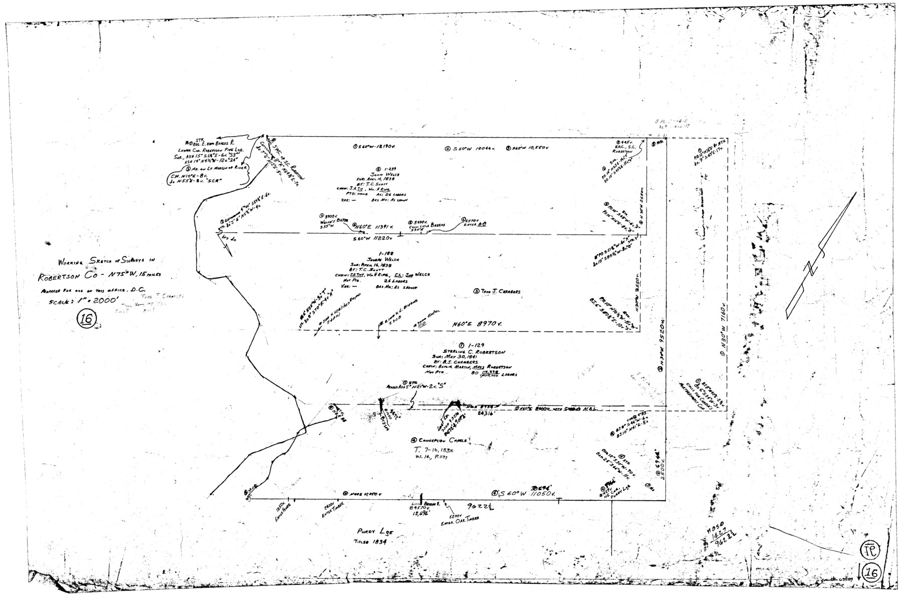
Robertson County Working Sketch 16
-
Map/Doc
63589
-
Collection
General Map Collection
-
People and Organizations
Drew Castaneda (Draftsman)
-
Counties
Robertson
-
Subjects
Surveying Working Sketch
-
Height x Width
21.7 x 33.0 inches
55.1 x 83.8 cm
-
Scale
1" = 2000 feet
Part of: General Map Collection
Duval County Working Sketch 24

Print $20.00
- Digital $50.00
Duval County Working Sketch 24
1944
Size 40.0 x 27.3 inches
Map/Doc 68748
Amistad International Reservoir on Rio Grande 70a

Print $20.00
- Digital $50.00
Amistad International Reservoir on Rio Grande 70a
1949
Size 28.5 x 39.5 inches
Map/Doc 73357
Baylor County Sketch File 12A

Print $8.00
- Digital $50.00
Baylor County Sketch File 12A
1900
Size 9.3 x 7.3 inches
Map/Doc 14148
Taylor County Working Sketch 11

Print $20.00
- Digital $50.00
Taylor County Working Sketch 11
1956
Size 23.0 x 24.4 inches
Map/Doc 69621
Brown County Working Sketch 16

Print $20.00
- Digital $50.00
Brown County Working Sketch 16
1993
Size 46.3 x 34.7 inches
Map/Doc 67781
Dallas County Boundary File 6f

Print $8.00
- Digital $50.00
Dallas County Boundary File 6f
Size 13.9 x 8.6 inches
Map/Doc 52271
Liberty County Sketch File 20

Print $6.00
- Digital $50.00
Liberty County Sketch File 20
Size 7.8 x 9.9 inches
Map/Doc 29925
[Beaumont, Sour Lake and Western Ry. Right of Way and Alignment - Frisco]
![64121, [Beaumont, Sour Lake and Western Ry. Right of Way and Alignment - Frisco], General Map Collection](https://historictexasmaps.com/wmedia_w700/maps/64121.tif.jpg)
Print $20.00
- Digital $50.00
[Beaumont, Sour Lake and Western Ry. Right of Way and Alignment - Frisco]
1910
Size 20.0 x 45.8 inches
Map/Doc 64121
Maps of Gulf Intracoastal Waterway, Texas - Sabine River to the Rio Grande and connecting waterways including ship channels

Print $20.00
- Digital $50.00
Maps of Gulf Intracoastal Waterway, Texas - Sabine River to the Rio Grande and connecting waterways including ship channels
1966
Size 14.6 x 22.2 inches
Map/Doc 61966
Flight Mission No. DCL-7C, Frame 58, Kenedy County

Print $20.00
- Digital $50.00
Flight Mission No. DCL-7C, Frame 58, Kenedy County
1943
Size 15.3 x 15.1 inches
Map/Doc 86046
Andrews County Working Sketch 28

Print $20.00
- Digital $50.00
Andrews County Working Sketch 28
Size 32.2 x 35.6 inches
Map/Doc 67074
Gaines County Working Sketch 7

Print $20.00
- Digital $50.00
Gaines County Working Sketch 7
1940
Size 16.5 x 38.5 inches
Map/Doc 69307
You may also like
Presidio County Rolled Sketch 28

Print $20.00
- Digital $50.00
Presidio County Rolled Sketch 28
1886
Size 25.0 x 45.8 inches
Map/Doc 76140
Flight Mission No. BRA-16M, Frame 150, Jefferson County

Print $20.00
- Digital $50.00
Flight Mission No. BRA-16M, Frame 150, Jefferson County
1953
Size 18.5 x 22.3 inches
Map/Doc 85756
Nueces County Sketch File 22

Print $20.00
- Digital $50.00
Nueces County Sketch File 22
Size 19.0 x 31.0 inches
Map/Doc 42181
[Sabine Pass]
![73343, [Sabine Pass], General Map Collection](https://historictexasmaps.com/wmedia_w700/maps/73343.tif.jpg)
Print $20.00
- Digital $50.00
[Sabine Pass]
1916
Size 18.5 x 26.5 inches
Map/Doc 73343
Jeff Davis County Working Sketch 31

Print $20.00
- Digital $50.00
Jeff Davis County Working Sketch 31
1969
Size 41.6 x 43.3 inches
Map/Doc 66526
Map of the Central and Montgomery Railroad

Print $20.00
- Digital $50.00
Map of the Central and Montgomery Railroad
1881
Size 12.6 x 36.8 inches
Map/Doc 64141
Motley County Working Sketch 4

Print $20.00
- Digital $50.00
Motley County Working Sketch 4
1914
Size 19.9 x 10.2 inches
Map/Doc 71209
League 206 Ochiltree County School Land

Print $20.00
- Digital $50.00
League 206 Ochiltree County School Land
Size 19.6 x 23.9 inches
Map/Doc 92479
Duval County Rolled Sketch 37

Print $20.00
- Digital $50.00
Duval County Rolled Sketch 37
1952
Size 29.2 x 24.6 inches
Map/Doc 5753
Wichita County Sketch File 36

Print $20.00
- Digital $50.00
Wichita County Sketch File 36
1894
Size 20.1 x 25.9 inches
Map/Doc 12689
General Highway Map. Detail of Cities and Towns in Tarrant County, Texas. City Map, Fort Worth and vicinity, Tarrant County, Texas

Print $20.00
General Highway Map. Detail of Cities and Towns in Tarrant County, Texas. City Map, Fort Worth and vicinity, Tarrant County, Texas
1961
Size 18.2 x 24.8 inches
Map/Doc 79669
Outer Continental Shelf Leasing Maps (Texas Offshore Operations)

Print $20.00
- Digital $50.00
Outer Continental Shelf Leasing Maps (Texas Offshore Operations)
Size 17.7 x 14.3 inches
Map/Doc 75856