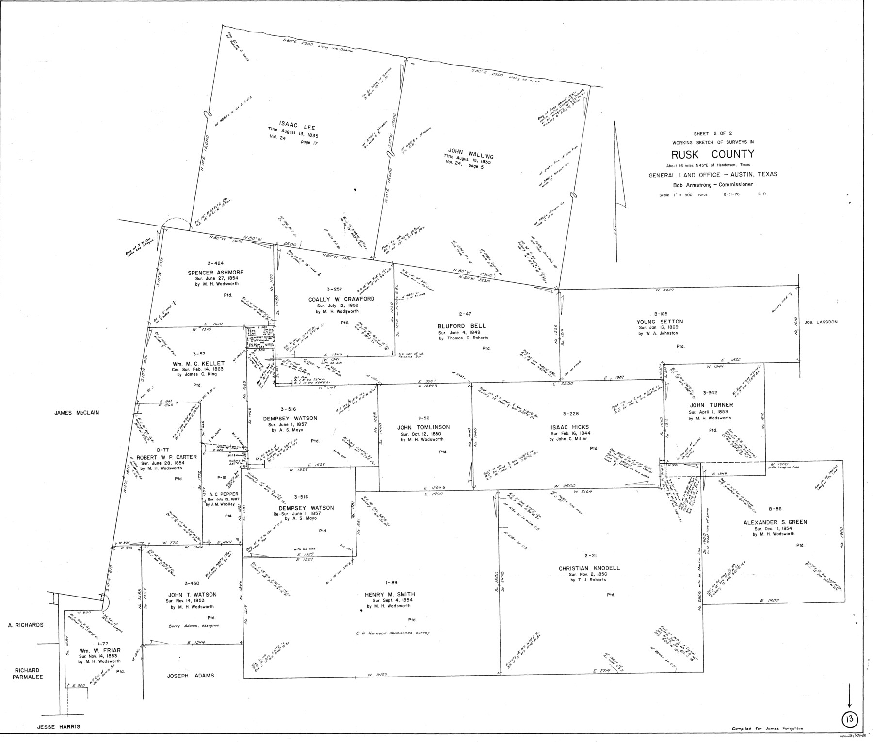
Rusk County Working Sketch 13
-
Map/Doc
63648
-
Collection
General Map Collection
-
Object Dates
8/11/1976 (Creation Date)
-
People and Organizations
Beverly Robison (Draftsman)
-
Counties
Rusk
-
Subjects
Surveying Working Sketch
-
Height x Width
33.2 x 39.1 inches
84.3 x 99.3 cm
-
Scale
1" = 300 varas
Part of: General Map Collection
Stephens County Working Sketch 13

Print $20.00
- Digital $50.00
Stephens County Working Sketch 13
1952
Size 23.9 x 33.3 inches
Map/Doc 63956
Coast of Texas and its defences

Print $20.00
- Digital $50.00
Coast of Texas and its defences
Size 27.6 x 18.2 inches
Map/Doc 72685
Motley County Sketch File 27 (S)

Print $6.00
- Digital $50.00
Motley County Sketch File 27 (S)
Size 14.3 x 8.3 inches
Map/Doc 32208
Childress County Rolled Sketch 8C

Print $20.00
- Digital $50.00
Childress County Rolled Sketch 8C
Size 23.5 x 21.0 inches
Map/Doc 5445
Flight Mission No. BRE-1P, Frame 11, Nueces County

Print $20.00
- Digital $50.00
Flight Mission No. BRE-1P, Frame 11, Nueces County
1956
Size 18.6 x 22.6 inches
Map/Doc 86619
Right of Way & Track Map, San Antonio & Aransas Pass Railway Co.

Print $40.00
- Digital $50.00
Right of Way & Track Map, San Antonio & Aransas Pass Railway Co.
1919
Size 25.0 x 56.7 inches
Map/Doc 64215
[Surveys along the Colorado River]
![112, [Surveys along the Colorado River], General Map Collection](https://historictexasmaps.com/wmedia_w700/maps/112.tif.jpg)
Print $2.00
- Digital $50.00
[Surveys along the Colorado River]
1841
Size 12.2 x 8.3 inches
Map/Doc 112
Austin Map and Street Guide [Verso]
![94163, Austin Map and Street Guide [Verso], General Map Collection](https://historictexasmaps.com/wmedia_w700/maps/94163.tif.jpg)
Austin Map and Street Guide [Verso]
1986
Size 35.5 x 22.8 inches
Map/Doc 94163
Baylor County Sketch File 26

Print $22.00
- Digital $50.00
Baylor County Sketch File 26
Size 14.6 x 9.0 inches
Map/Doc 14215
Montgomery County Sketch File 18

Print $20.00
- Digital $50.00
Montgomery County Sketch File 18
1899
Size 22.1 x 19.6 inches
Map/Doc 42122
Flight Mission No. CLL-3N, Frame 17, Willacy County

Print $20.00
- Digital $50.00
Flight Mission No. CLL-3N, Frame 17, Willacy County
1954
Size 18.5 x 22.2 inches
Map/Doc 87083
Taylor County Rolled Sketch 27

Print $20.00
- Digital $50.00
Taylor County Rolled Sketch 27
Size 37.5 x 30.3 inches
Map/Doc 7918
You may also like
Nueces County Rolled Sketch 49

Print $20.00
- Digital $50.00
Nueces County Rolled Sketch 49
1979
Size 21.1 x 20.7 inches
Map/Doc 6888
[Office Sketch Showing George Tenille Grant, Brazoria County, Texas]
![75831, [Office Sketch Showing George Tenille Grant, Brazoria County, Texas], Maddox Collection](https://historictexasmaps.com/wmedia_w700/maps/75831.tif.jpg)
Print $20.00
- Digital $50.00
[Office Sketch Showing George Tenille Grant, Brazoria County, Texas]
Size 38.1 x 28.7 inches
Map/Doc 75831
Map of Henderson County

Print $40.00
- Digital $50.00
Map of Henderson County
1897
Size 28.9 x 58.9 inches
Map/Doc 66860
DeWitt County Working Sketch 6

Print $20.00
- Digital $50.00
DeWitt County Working Sketch 6
1977
Size 30.6 x 26.6 inches
Map/Doc 68596
Nueces County Rolled Sketch 48

Print $20.00
- Digital $50.00
Nueces County Rolled Sketch 48
1957
Size 33.1 x 45.1 inches
Map/Doc 6887

Ellwood Farms Situated in Hockley, Lamb, and Hale Counties, Texas

Print $20.00
- Digital $50.00
Ellwood Farms Situated in Hockley, Lamb, and Hale Counties, Texas
Size 20.3 x 30.1 inches
Map/Doc 92229
[H. & T. C. , Block 47, Sections 26- 38]
![91255, [H. & T. C. , Block 47, Sections 26- 38], Twichell Survey Records](https://historictexasmaps.com/wmedia_w700/maps/91255-1.tif.jpg)
Print $2.00
- Digital $50.00
[H. & T. C. , Block 47, Sections 26- 38]
Size 14.5 x 9.2 inches
Map/Doc 91255
[Galveston, Harrisburg & San Antonio from El Paso-Presidio county boundary to Presidio-Pecos county boundary]
![64718, [Galveston, Harrisburg & San Antonio from El Paso-Presidio county boundary to Presidio-Pecos county boundary], General Map Collection](https://historictexasmaps.com/wmedia_w700/maps/64718.tif.jpg)
Print $40.00
- Digital $50.00
[Galveston, Harrisburg & San Antonio from El Paso-Presidio county boundary to Presidio-Pecos county boundary]
Size 106.1 x 44.3 inches
Map/Doc 64718
Webb County Rolled Sketch 53

Print $40.00
- Digital $50.00
Webb County Rolled Sketch 53
1944
Size 83.5 x 28.6 inches
Map/Doc 49483
Colorado County Sketch File 6

Print $8.00
- Digital $50.00
Colorado County Sketch File 6
1860
Size 8.4 x 7.0 inches
Map/Doc 18921
Flight Mission No. DCL-3C, Frame 156, Kenedy County

Print $20.00
- Digital $50.00
Flight Mission No. DCL-3C, Frame 156, Kenedy County
1943
Size 18.5 x 22.3 inches
Map/Doc 85804