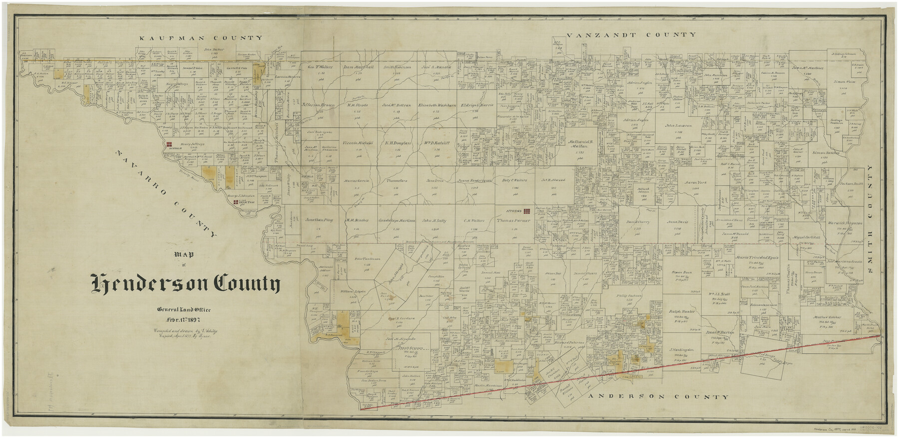
Map of Henderson County
-
Map/Doc
66860
-
Collection
General Map Collection
-
Object Dates
1897/2/17 (Creation Date)
-
People and Organizations
Texas General Land Office (Publisher)
Ed. Schutze (Compiler)
Ed. Schutze (Draftsman)
-
Counties
Henderson
-
Subjects
County
-
Height x Width
28.9 x 58.9 inches
73.4 x 149.6 cm
-
Comments
Copied in April 1899 by Wynne.
Part of: General Map Collection
International boundary between the United States and Mexico in the Rio Grande and Colorado River delineated in accordance with the Treaty of November 23, 1970 - Volume 1

International boundary between the United States and Mexico in the Rio Grande and Colorado River delineated in accordance with the Treaty of November 23, 1970 - Volume 1
1972
Map/Doc 1747
Flight Mission No. CRC-4R, Frame 105, Chambers County

Print $20.00
- Digital $50.00
Flight Mission No. CRC-4R, Frame 105, Chambers County
1956
Size 18.8 x 22.4 inches
Map/Doc 84902
Cameron County Sketch File 5

Print $4.00
- Digital $50.00
Cameron County Sketch File 5
1978
Size 11.1 x 8.7 inches
Map/Doc 17030
Denton County Boundary File 1a

Print $24.00
- Digital $50.00
Denton County Boundary File 1a
Size 12.4 x 8.1 inches
Map/Doc 52401
Shackelford County Rolled Sketch 3

Print $40.00
- Digital $50.00
Shackelford County Rolled Sketch 3
1955
Size 35.4 x 49.9 inches
Map/Doc 9915
Stephens County

Print $20.00
- Digital $50.00
Stephens County
1940
Size 42.9 x 41.0 inches
Map/Doc 63045
San Jacinto County Working Sketch 9
Print $20.00
- Digital $50.00
San Jacinto County Working Sketch 9
1935
Size 36.1 x 42.1 inches
Map/Doc 63722
Bee County Sketch File 19

Print $6.00
- Digital $50.00
Bee County Sketch File 19
Size 12.7 x 8.4 inches
Map/Doc 14305
Stephens County Working Sketch 1

Print $20.00
- Digital $50.00
Stephens County Working Sketch 1
Size 13.5 x 16.1 inches
Map/Doc 63944
Ward County Working Sketch 2

Print $20.00
- Digital $50.00
Ward County Working Sketch 2
1937
Size 22.9 x 28.7 inches
Map/Doc 72308
Presidio County Rolled Sketch 105B

Print $20.00
- Digital $50.00
Presidio County Rolled Sketch 105B
Size 46.5 x 36.5 inches
Map/Doc 9789
Real County Rolled Sketch 8

Print $20.00
- Digital $50.00
Real County Rolled Sketch 8
1967
Size 32.0 x 36.7 inches
Map/Doc 9833
You may also like
Val Verde County Working Sketch 103

Print $20.00
- Digital $50.00
Val Verde County Working Sketch 103
1981
Size 37.1 x 39.9 inches
Map/Doc 72238
Flight Mission No. BRA-7M, Frame 73, Jefferson County

Print $20.00
- Digital $50.00
Flight Mission No. BRA-7M, Frame 73, Jefferson County
1953
Size 18.7 x 22.4 inches
Map/Doc 85495
Flight Mission No. DQN-2K, Frame 136, Calhoun County

Print $20.00
- Digital $50.00
Flight Mission No. DQN-2K, Frame 136, Calhoun County
1953
Size 18.5 x 15.8 inches
Map/Doc 84305
Brewster County Rolled Sketch 49B

Print $20.00
- Digital $50.00
Brewster County Rolled Sketch 49B
Size 14.2 x 24.2 inches
Map/Doc 5225
Map of Europe to illustrate Olney's school geography (Inset: Central Europe)

Print $20.00
- Digital $50.00
Map of Europe to illustrate Olney's school geography (Inset: Central Europe)
1844
Size 12.1 x 19.0 inches
Map/Doc 93546
General Highway Map, Rusk County, Texas

Print $20.00
General Highway Map, Rusk County, Texas
1961
Size 24.9 x 18.2 inches
Map/Doc 79643
Pressler's Map of the State of Texas

Print $40.00
- Digital $50.00
Pressler's Map of the State of Texas
1858
Size 47.6 x 51.9 inches
Map/Doc 709
Cottle County Sketch File 3

Print $4.00
- Digital $50.00
Cottle County Sketch File 3
Size 10.0 x 8.4 inches
Map/Doc 19457
Navigation Maps of Gulf Intracoastal Waterway, Port Arthur to Brownsville, Texas

Print $4.00
- Digital $50.00
Navigation Maps of Gulf Intracoastal Waterway, Port Arthur to Brownsville, Texas
1951
Size 16.6 x 21.3 inches
Map/Doc 65451
San Jacinto County Rolled Sketch 12

Print $20.00
- Digital $50.00
San Jacinto County Rolled Sketch 12
1948
Size 24.2 x 32.5 inches
Map/Doc 7561
Webb County Sketch File 23

Print $20.00
- Digital $50.00
Webb County Sketch File 23
1923
Size 25.4 x 16.3 inches
Map/Doc 12638
