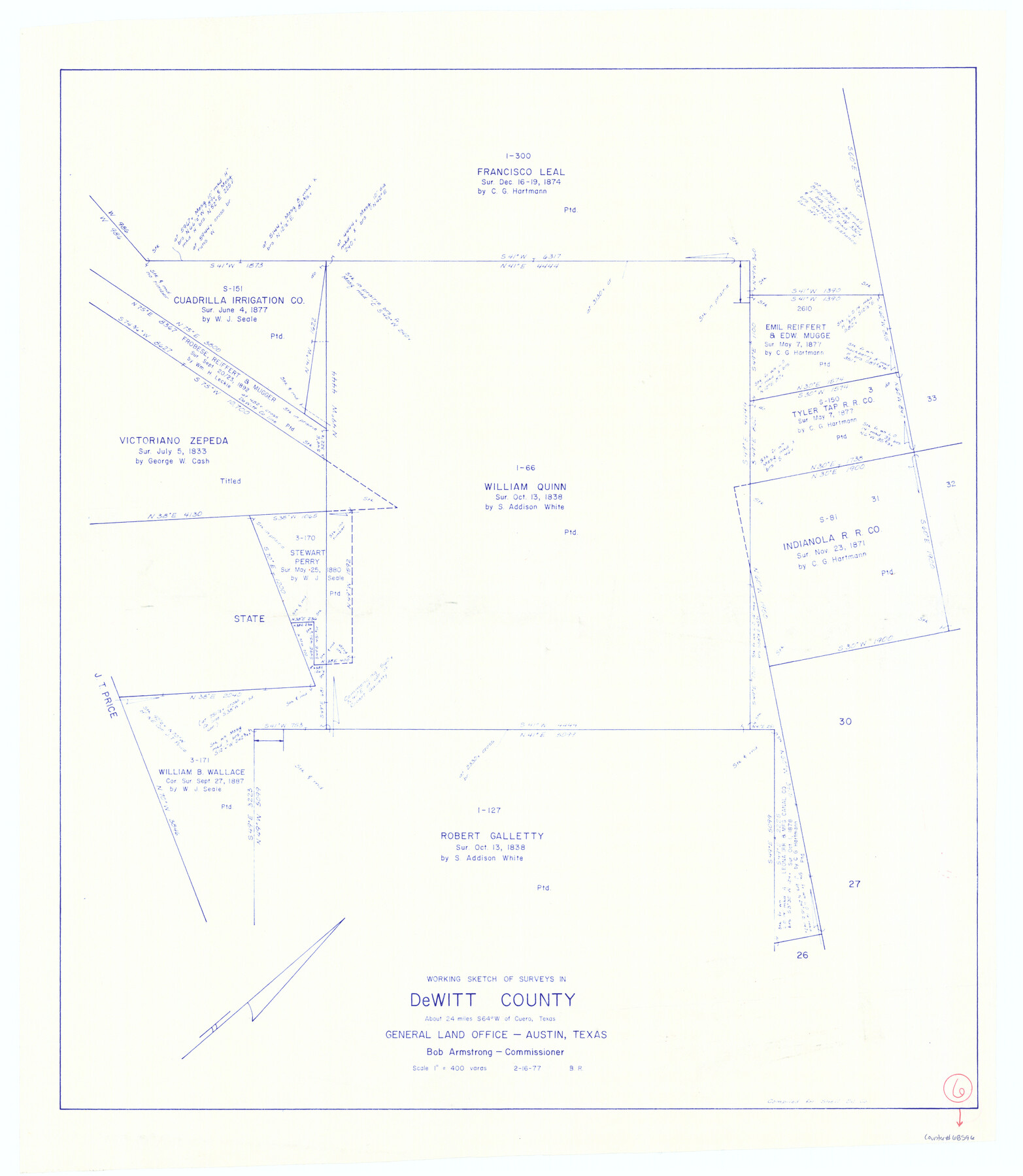
DeWitt County Working Sketch 6
-
Map/Doc
68596
-
Collection
General Map Collection
-
Object Dates
2/16/1977 (Creation Date)
-
People and Organizations
Beverly Robison (Draftsman)
-
Counties
DeWitt
-
Subjects
Surveying Working Sketch
-
Height x Width
30.6 x 26.6 inches
77.7 x 67.6 cm
-
Scale
1" = 400 varas
Part of: General Map Collection

[Map of Matagorda County]
![3841, [Map of Matagorda County], General Map Collection](https://historictexasmaps.com/wmedia_w700/maps/3841-1.tif.jpg)
Print $20.00
- Digital $50.00
[Map of Matagorda County]
Size 24.4 x 25.6 inches
Map/Doc 3841
1882 Map of the Texas & Pacific R-Y Reserve

Print $40.00
- Digital $50.00
1882 Map of the Texas & Pacific R-Y Reserve
1888
Size 95.6 x 42.5 inches
Map/Doc 2299
Real County Working Sketch 35

Print $20.00
- Digital $50.00
Real County Working Sketch 35
1949
Size 27.7 x 23.6 inches
Map/Doc 71927
Maps of Gulf Intracoastal Waterway, Texas - Sabine River to the Rio Grande and connecting waterways including ship channels

Print $20.00
- Digital $50.00
Maps of Gulf Intracoastal Waterway, Texas - Sabine River to the Rio Grande and connecting waterways including ship channels
1966
Size 14.6 x 22.3 inches
Map/Doc 61925
Pecos County Working Sketch 33

Print $20.00
- Digital $50.00
Pecos County Working Sketch 33
1937
Size 26.7 x 35.6 inches
Map/Doc 71505
Flight Mission No. CUI-1H, Frame 97, Milam County

Print $20.00
- Digital $50.00
Flight Mission No. CUI-1H, Frame 97, Milam County
1951
Size 18.5 x 22.2 inches
Map/Doc 86605
Right of Way & Track Map, St. Louis, Brownsville & Mexico Ry. operated by St. Louis, Brownsville & Mexico Ry. Co.

Print $40.00
- Digital $50.00
Right of Way & Track Map, St. Louis, Brownsville & Mexico Ry. operated by St. Louis, Brownsville & Mexico Ry. Co.
1919
Size 25.5 x 57.1 inches
Map/Doc 64624
Reagan County Rolled Sketch 34

Print $40.00
- Digital $50.00
Reagan County Rolled Sketch 34
1956
Size 53.2 x 40.3 inches
Map/Doc 9829
Map of Llano County

Print $20.00
- Digital $50.00
Map of Llano County
1877
Size 19.9 x 25.7 inches
Map/Doc 3824
Tom Green County Working Sketch 11

Print $20.00
- Digital $50.00
Tom Green County Working Sketch 11
1968
Size 33.9 x 39.2 inches
Map/Doc 69380
Denton County Sketch File 23

Print $5.00
- Digital $50.00
Denton County Sketch File 23
1862
Size 9.3 x 11.4 inches
Map/Doc 20748
You may also like
Edwards County Working Sketch 106

Print $20.00
- Digital $50.00
Edwards County Working Sketch 106
1972
Size 32.3 x 26.5 inches
Map/Doc 68982
Right of Way and Track Map of The Missouri, Kansas & Texas Railway of Texas

Print $40.00
- Digital $50.00
Right of Way and Track Map of The Missouri, Kansas & Texas Railway of Texas
1918
Size 25.6 x 52.6 inches
Map/Doc 64525
Uvalde County Working Sketch 29

Print $20.00
- Digital $50.00
Uvalde County Working Sketch 29
1958
Size 25.3 x 41.0 inches
Map/Doc 72099
Childress County Working Sketch 5

Print $20.00
- Digital $50.00
Childress County Working Sketch 5
1948
Size 19.6 x 23.5 inches
Map/Doc 68021
Crane County State of Texas

Print $20.00
- Digital $50.00
Crane County State of Texas
1889
Size 22.9 x 17.6 inches
Map/Doc 4524
Aransas County Working Sketch 18

Print $20.00
- Digital $50.00
Aransas County Working Sketch 18
1961
Size 36.0 x 30.7 inches
Map/Doc 67185
Harris County Sketch File 19

Print $4.00
- Digital $50.00
Harris County Sketch File 19
1862
Size 8.7 x 13.9 inches
Map/Doc 25366
Travis County

Print $40.00
- Digital $50.00
Travis County
1963
Size 37.7 x 50.7 inches
Map/Doc 73597
[Plat of Colorado River Survey, McCulloch County]
![2462, [Plat of Colorado River Survey, McCulloch County], General Map Collection](https://historictexasmaps.com/wmedia_w700/maps/2462-1.tif.jpg)
Print $40.00
- Digital $50.00
[Plat of Colorado River Survey, McCulloch County]
1918
Size 40.3 x 159.2 inches
Map/Doc 2462
Frio County Working Sketch 2

Print $20.00
- Digital $50.00
Frio County Working Sketch 2
1914
Size 17.9 x 15.1 inches
Map/Doc 69276
Montgomery County Working Sketch 63

Print $20.00
- Digital $50.00
Montgomery County Working Sketch 63
1964
Size 31.6 x 36.7 inches
Map/Doc 71170
