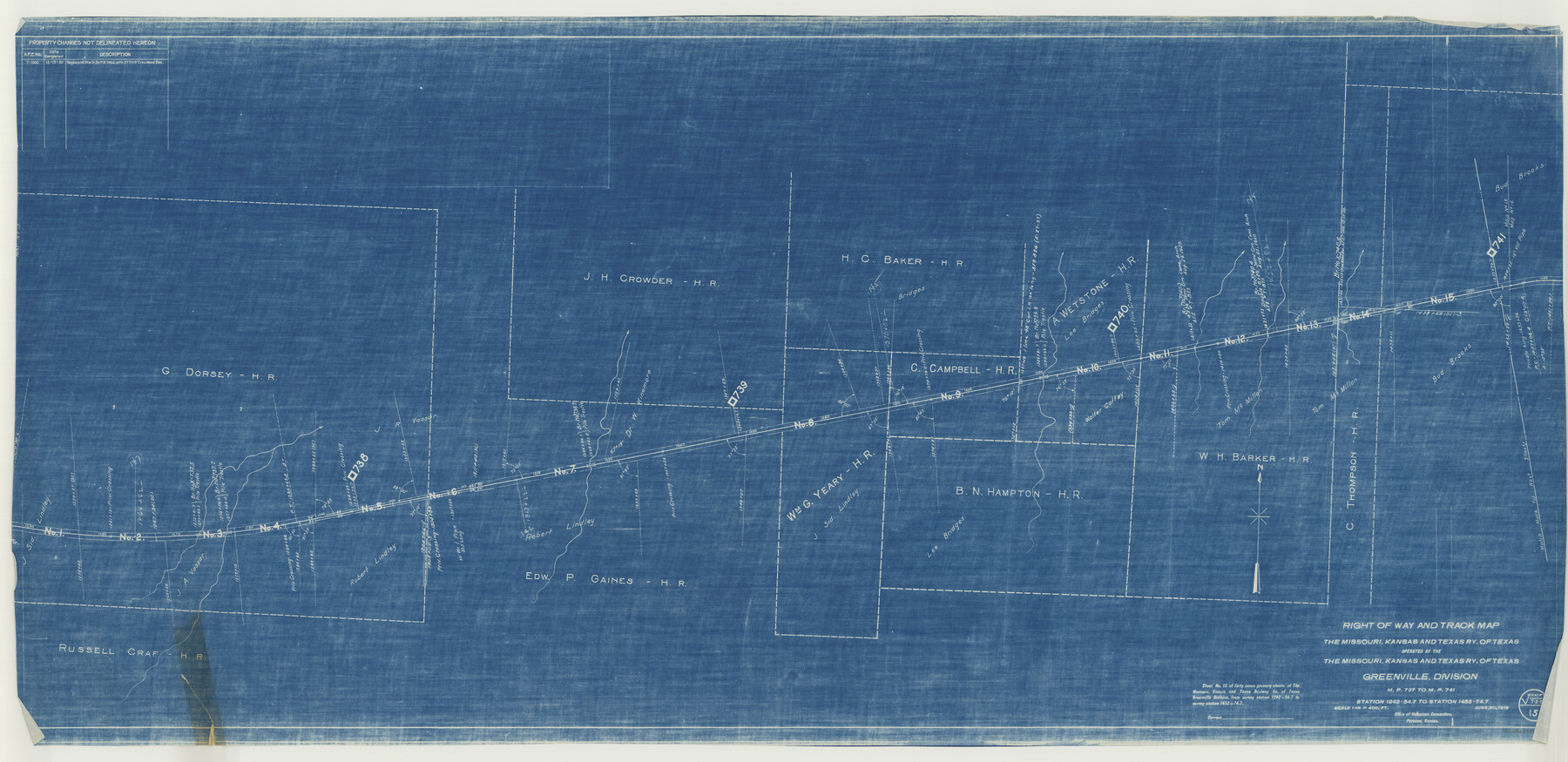
Right of Way and Track Map of The Missouri, Kansas & Texas Railway of Texas
Z-2-162
-
Map/Doc
64525
-
Collection
General Map Collection
-
Object Dates
1918/6/30 (Creation Date)
-
Counties
Hopkins Hunt
-
Subjects
Railroads
-
Height x Width
25.6 x 52.6 inches
65.0 x 133.6 cm
-
Medium
blueprint/diazo
-
Scale
1 in. = 400 ft.
-
Comments
Operated by The Missouri, Kansas and Texas Railway of Texas. Greenville Division. Station 1242+54.7 to Station 1453+74.7. See counter nos. 64526 through 64533 for other sheets of the map.
-
Features
MK&T
Part of: General Map Collection

Menard County Working Sketch 16

Print $40.00
- Digital $50.00
Menard County Working Sketch 16
1946
Size 49.1 x 39.1 inches
Map/Doc 70963
Hudspeth County Rolled Sketch 19

Print $20.00
- Digital $50.00
Hudspeth County Rolled Sketch 19
Size 47.8 x 44.6 inches
Map/Doc 9205
Schleicher County Sketch File 7

Print $10.00
- Digital $50.00
Schleicher County Sketch File 7
1881
Size 13.0 x 8.2 inches
Map/Doc 36474
Martin County Boundary File 62

Print $110.00
- Digital $50.00
Martin County Boundary File 62
Size 8.7 x 4.0 inches
Map/Doc 56782
Nueces County Sketch File 23

Print $36.00
- Digital $50.00
Nueces County Sketch File 23
1886
Size 11.2 x 8.6 inches
Map/Doc 32563
Flight Mission No. DIX-10P, Frame 171, Aransas County

Print $20.00
- Digital $50.00
Flight Mission No. DIX-10P, Frame 171, Aransas County
1956
Size 18.8 x 22.3 inches
Map/Doc 83961
Map of the River Sabine from Logan's Ferry to 32nd degree of north latitude

Print $2.00
- Digital $50.00
Map of the River Sabine from Logan's Ferry to 32nd degree of north latitude
1841
Size 8.6 x 10.5 inches
Map/Doc 65388
Map of Parker County

Print $20.00
- Digital $50.00
Map of Parker County
1879
Size 23.9 x 19.0 inches
Map/Doc 3947
Texas Gulf Coast Map from the Sabine River to the Rio Grande as subdivided for mineral development

Print $20.00
- Digital $50.00
Texas Gulf Coast Map from the Sabine River to the Rio Grande as subdivided for mineral development
1948
Size 45.0 x 39.9 inches
Map/Doc 2911
Parker County Working Sketch 11

Print $20.00
- Digital $50.00
Parker County Working Sketch 11
1969
Map/Doc 71461
Flight Mission No. DIX-10P, Frame 144, Aransas County

Print $20.00
- Digital $50.00
Flight Mission No. DIX-10P, Frame 144, Aransas County
1956
Size 18.6 x 22.3 inches
Map/Doc 83946
You may also like
[Sketch for Mineral Application 24072, San Jacinto River]
![65589, [Sketch for Mineral Application 24072, San Jacinto River], General Map Collection](https://historictexasmaps.com/wmedia_w700/maps/65589.tif.jpg)
Print $20.00
- Digital $50.00
[Sketch for Mineral Application 24072, San Jacinto River]
1929
Size 29.6 x 14.7 inches
Map/Doc 65589
[Galveston, Harrisburg & San Antonio through El Paso County]
![64012, [Galveston, Harrisburg & San Antonio through El Paso County], General Map Collection](https://historictexasmaps.com/wmedia_w700/maps/64012.tif.jpg)
Print $20.00
- Digital $50.00
[Galveston, Harrisburg & San Antonio through El Paso County]
1906
Size 13.6 x 33.8 inches
Map/Doc 64012
Maps of Gulf Intracoastal Waterway, Texas - Sabine River to the Rio Grande and connecting waterways including ship channels

Print $20.00
- Digital $50.00
Maps of Gulf Intracoastal Waterway, Texas - Sabine River to the Rio Grande and connecting waterways including ship channels
1966
Size 14.6 x 22.2 inches
Map/Doc 61958
Freestone County

Print $20.00
- Digital $50.00
Freestone County
1988
Size 45.8 x 42.6 inches
Map/Doc 73152
Sabine Bank to East Bay including Heald Bank

Print $20.00
- Digital $50.00
Sabine Bank to East Bay including Heald Bank
1946
Size 44.8 x 33.9 inches
Map/Doc 69845
Flight Mission No. BRA-7M, Frame 29, Jefferson County

Print $20.00
- Digital $50.00
Flight Mission No. BRA-7M, Frame 29, Jefferson County
1953
Size 18.5 x 22.3 inches
Map/Doc 85480
Jackson County Sketch File 11

Print $20.00
- Digital $50.00
Jackson County Sketch File 11
1922
Size 15.7 x 30.1 inches
Map/Doc 11837
Brewster County Rolled Sketch 29
Print $20.00
- Digital $50.00
Brewster County Rolled Sketch 29
1910
Size 17.5 x 18.5 inches
Map/Doc 5216
Martin County Boundary File 1

Print $10.00
- Digital $50.00
Martin County Boundary File 1
Size 11.2 x 8.7 inches
Map/Doc 56757
[Blocks C4, S1, K and C3 in Northern Hale/Southern Swisher Counties]
![91858, [Blocks C4, S1, K and C3 in Northern Hale/Southern Swisher Counties], Twichell Survey Records](https://historictexasmaps.com/wmedia_w700/maps/91858-1.tif.jpg)
Print $2.00
- Digital $50.00
[Blocks C4, S1, K and C3 in Northern Hale/Southern Swisher Counties]
1906
Size 15.0 x 8.7 inches
Map/Doc 91858
Map of part of the State of Texas

Print $3.00
- Digital $50.00
Map of part of the State of Texas
1857
Size 8.0 x 9.6 inches
Map/Doc 95363
Flight Mission No. BRE-2P, Frame 36, Nueces County

Print $20.00
- Digital $50.00
Flight Mission No. BRE-2P, Frame 36, Nueces County
1956
Size 18.5 x 22.7 inches
Map/Doc 86738