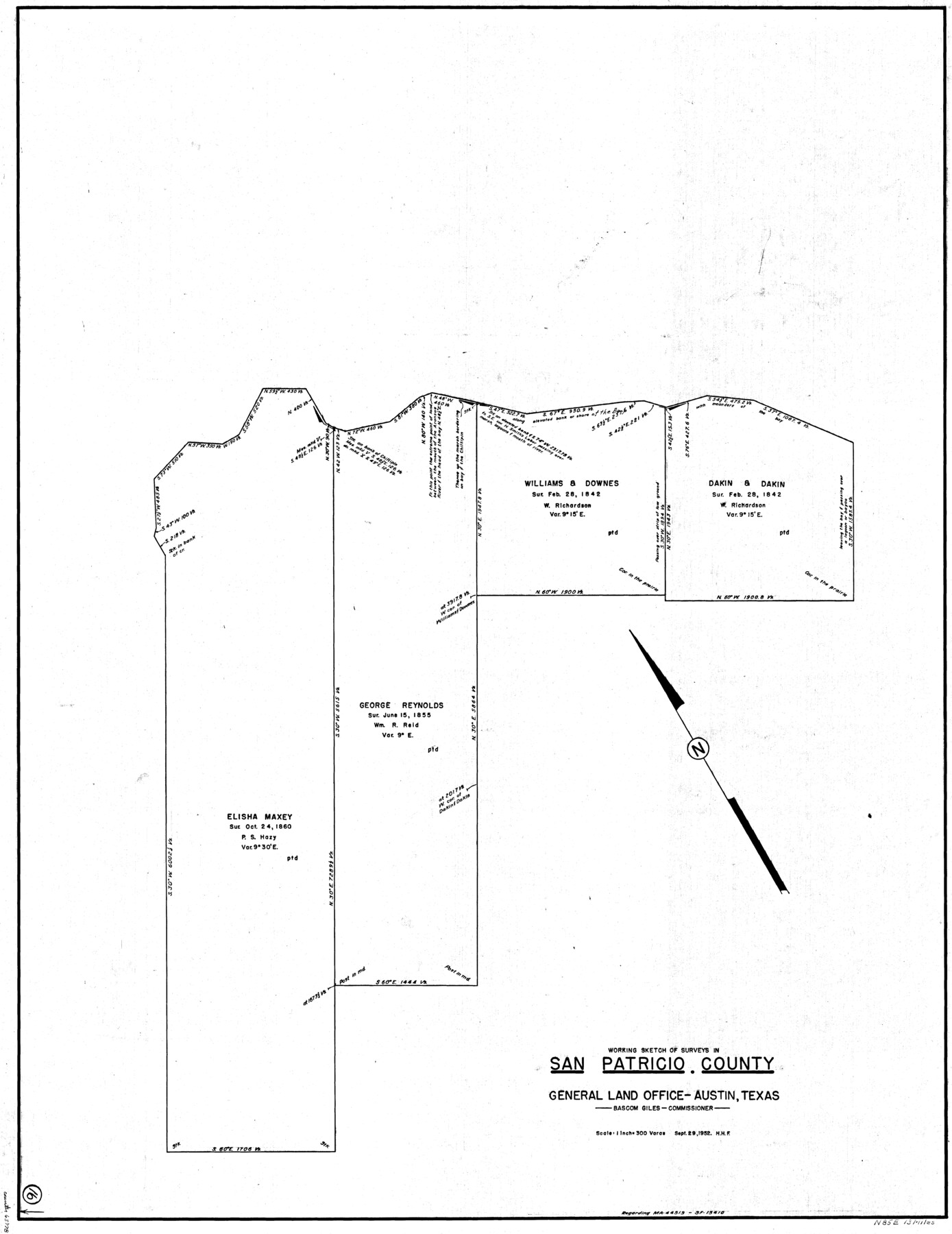
San Patricio County Working Sketch 16
-
Map/Doc
63778
-
Collection
General Map Collection
-
Object Dates
9/29/1952 (Creation Date)
-
People and Organizations
Herman H. Forbes (Draftsman)
-
Counties
San Patricio
-
Subjects
Surveying Working Sketch
-
Height x Width
41.6 x 32.1 inches
105.7 x 81.5 cm
-
Scale
1" = 300 varas
Part of: General Map Collection
Flight Mission No. BRE-2P, Frame 63, Nueces County

Print $20.00
- Digital $50.00
Flight Mission No. BRE-2P, Frame 63, Nueces County
1956
Size 18.5 x 22.5 inches
Map/Doc 86758
El Paso County Rolled Sketch 26

Print $20.00
- Digital $50.00
El Paso County Rolled Sketch 26
Size 44.5 x 34.1 inches
Map/Doc 8857
Reeves County Rolled Sketch 33

Print $20.00
- Digital $50.00
Reeves County Rolled Sketch 33
Size 24.2 x 36.5 inches
Map/Doc 7502
Sutton County Rolled Sketch 52

Print $20.00
- Digital $50.00
Sutton County Rolled Sketch 52
1950
Size 20.8 x 35.2 inches
Map/Doc 7892
Flight Mission No. CRC-3R, Frame 165, Chambers County

Print $20.00
- Digital $50.00
Flight Mission No. CRC-3R, Frame 165, Chambers County
1956
Size 18.8 x 22.5 inches
Map/Doc 84847
Webb County Sketch File 14-2

Print $6.00
- Digital $50.00
Webb County Sketch File 14-2
1936
Size 14.3 x 8.7 inches
Map/Doc 39817
Flight Mission No. DQN-1K, Frame 30, Calhoun County

Print $20.00
- Digital $50.00
Flight Mission No. DQN-1K, Frame 30, Calhoun County
1953
Size 18.6 x 22.2 inches
Map/Doc 84135
Jasper County Sketch File 32

Print $20.00
- Digital $50.00
Jasper County Sketch File 32
1906
Size 28.0 x 22.3 inches
Map/Doc 11853
Map of the River Sabine from its mouth on the Gulf of Mexico in the Sea to Logan's Ferry in Latitude 31°58'24" North

Print $40.00
- Digital $50.00
Map of the River Sabine from its mouth on the Gulf of Mexico in the Sea to Logan's Ferry in Latitude 31°58'24" North
1842
Size 173.2 x 31.0 inches
Map/Doc 1744
Flight Mission No. CUG-1P, Frame 54, Kleberg County

Print $20.00
- Digital $50.00
Flight Mission No. CUG-1P, Frame 54, Kleberg County
1956
Size 18.5 x 22.3 inches
Map/Doc 86132
Flight Mission No. DQO-8K, Frame 85, Galveston County

Print $20.00
- Digital $50.00
Flight Mission No. DQO-8K, Frame 85, Galveston County
1952
Size 18.7 x 22.5 inches
Map/Doc 85187
Stephens County

Print $20.00
- Digital $50.00
Stephens County
1879
Size 27.8 x 19.6 inches
Map/Doc 4051
You may also like
Frio County Sketch File A

Print $40.00
- Digital $50.00
Frio County Sketch File A
1878
Size 16.4 x 13.4 inches
Map/Doc 23099
Montague County Working Sketch 26

Print $20.00
- Digital $50.00
Montague County Working Sketch 26
1956
Size 23.5 x 23.2 inches
Map/Doc 71092
Val Verde County Rolled Sketch 70

Print $20.00
- Digital $50.00
Val Verde County Rolled Sketch 70
1958
Size 23.2 x 18.8 inches
Map/Doc 8132
Duval County Sketch File 76

Print $20.00
- Digital $50.00
Duval County Sketch File 76
1959
Size 15.1 x 27.3 inches
Map/Doc 11410
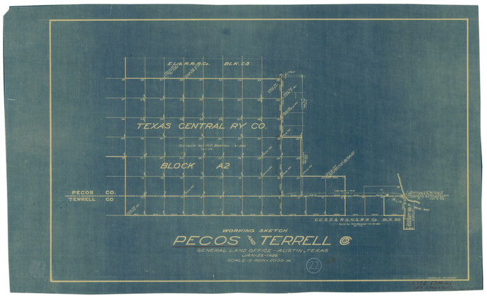
Pecos County Working Sketch 22
Print $20.00
- Digital $50.00
Pecos County Working Sketch 22
1926
Size 14.3 x 23.5 inches
Map/Doc 71492
Robertson County Sketch File 5 1/2

Print $2.00
- Digital $50.00
Robertson County Sketch File 5 1/2
Size 8.1 x 4.2 inches
Map/Doc 35361
Jackson County Sketch File 27

Print $20.00
- Digital $50.00
Jackson County Sketch File 27
1938
Size 25.6 x 24.8 inches
Map/Doc 11847
Karnes County Rolled Sketch 2

Print $20.00
- Digital $50.00
Karnes County Rolled Sketch 2
1957
Size 35.3 x 30.0 inches
Map/Doc 6453
[East Line, Hemphill County]
![90725, [East Line, Hemphill County], Twichell Survey Records](https://historictexasmaps.com/wmedia_w700/maps/90725-1.tif.jpg)
Print $2.00
- Digital $50.00
[East Line, Hemphill County]
Size 5.4 x 15.0 inches
Map/Doc 90725
[Surveys in the Jefferson District: G. A. Patillo's league, Big Sandy, Sabine Bay]
![69727, [Surveys in the Jefferson District: G. A. Patillo's league, Big Sandy, Sabine Bay], General Map Collection](https://historictexasmaps.com/wmedia_w700/maps/69727-1.tif.jpg)
Print $20.00
- Digital $50.00
[Surveys in the Jefferson District: G. A. Patillo's league, Big Sandy, Sabine Bay]
1846
Size 14.4 x 20.9 inches
Map/Doc 69727
Flight Mission No. BRA-7M, Frame 133, Jefferson County

Print $20.00
- Digital $50.00
Flight Mission No. BRA-7M, Frame 133, Jefferson County
1953
Size 18.6 x 22.3 inches
Map/Doc 85527
Hamilton County Working Sketch 35

Print $20.00
- Digital $50.00
Hamilton County Working Sketch 35
Size 26.3 x 19.1 inches
Map/Doc 78286