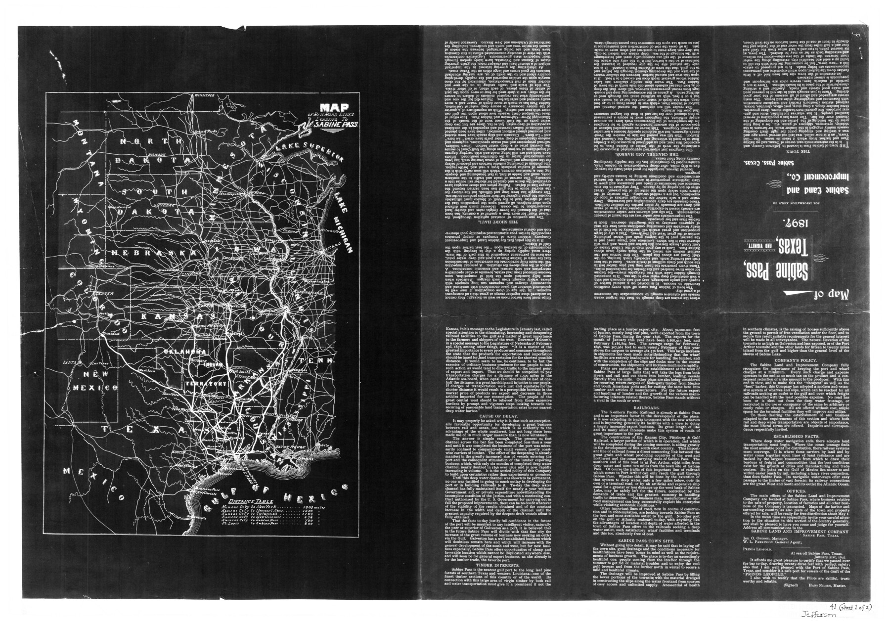
Jefferson County Rolled Sketch 41
Map of Railroad Lines leading to Sabine Pass
-
Map/Doc
6400
-
Collection
General Map Collection
-
Object Dates
1897 (Creation Date)
9/28/1957 (File Date)
-
Counties
Jefferson
-
Subjects
Railroads Surveying Rolled Sketch
-
Height x Width
17.6 x 25.4 inches
44.7 x 64.5 cm
-
Medium
photostat, negative
-
Comments
See Jefferson County Rolled Sketch 41 (6399) for recto.
Related maps
Jefferson County Rolled Sketch 41

Print $20.00
- Digital $50.00
Jefferson County Rolled Sketch 41
1897
Size 25.1 x 17.8 inches
Map/Doc 6399
Part of: General Map Collection
Walker County Working Sketch 11

Print $20.00
- Digital $50.00
Walker County Working Sketch 11
1935
Size 28.2 x 38.8 inches
Map/Doc 72291
Flight Mission No. BRA-8M, Frame 115, Jefferson County

Print $20.00
- Digital $50.00
Flight Mission No. BRA-8M, Frame 115, Jefferson County
1953
Size 18.6 x 22.2 inches
Map/Doc 85611
Hudspeth County Rolled Sketch 36

Print $20.00
- Digital $50.00
Hudspeth County Rolled Sketch 36
1952
Size 30.8 x 19.9 inches
Map/Doc 6249
Motley County Sketch File 7a (N)

Print $40.00
- Digital $50.00
Motley County Sketch File 7a (N)
1895
Size 13.5 x 14.4 inches
Map/Doc 32014
Kerr County State Real Property Sketch 2

Print $2.00
- Digital $50.00
Kerr County State Real Property Sketch 2
2007
Size 10.7 x 8.6 inches
Map/Doc 88675
Nueces County NRC Article 33.136 Location Key Sheet

Print $20.00
- Digital $50.00
Nueces County NRC Article 33.136 Location Key Sheet
1975
Size 27.0 x 23.0 inches
Map/Doc 88585
State Prison Lands Transferred to A&M College, Forest Division, Cherokee County

Print $4.00
- Digital $50.00
State Prison Lands Transferred to A&M College, Forest Division, Cherokee County
1932
Size 11.1 x 20.1 inches
Map/Doc 65086
Montgomery County Rolled Sketch 40

Print $393.00
- Digital $50.00
Montgomery County Rolled Sketch 40
1970
Size 10.3 x 16.0 inches
Map/Doc 46793
Frio County Working Sketch 13

Print $20.00
- Digital $50.00
Frio County Working Sketch 13
1954
Size 23.3 x 35.5 inches
Map/Doc 69287
Pecos County Rolled Sketch 159

Print $46.00
- Digital $50.00
Pecos County Rolled Sketch 159
1964
Size 31.9 x 38.3 inches
Map/Doc 7285
Zavala County Rolled Sketch 25

Print $20.00
- Digital $50.00
Zavala County Rolled Sketch 25
1952
Size 38.4 x 43.4 inches
Map/Doc 10176
Mills County Boundary File 7

Print $2.00
- Digital $50.00
Mills County Boundary File 7
Size 14.2 x 8.6 inches
Map/Doc 57312
You may also like
SW/4 of County, B.S.& F. Bk. M-10, J.W.Woodburn Bk.B-1 & G.C.&S.F. Bk.BIGN

Print $20.00
- Digital $50.00
SW/4 of County, B.S.& F. Bk. M-10, J.W.Woodburn Bk.B-1 & G.C.&S.F. Bk.BIGN
Size 34.6 x 27.0 inches
Map/Doc 90266
Navarro County Rolled Sketch 6

Print $40.00
- Digital $50.00
Navarro County Rolled Sketch 6
Size 43.1 x 50.8 inches
Map/Doc 10307
Map of San Jacinto County

Print $20.00
- Digital $50.00
Map of San Jacinto County
1879
Size 27.0 x 18.1 inches
Map/Doc 4624
Amistad International Reservoir on Rio Grande 78

Print $20.00
- Digital $50.00
Amistad International Reservoir on Rio Grande 78
1949
Size 28.5 x 40.2 inches
Map/Doc 75506
Galveston to Rio Grande

Print $20.00
- Digital $50.00
Galveston to Rio Grande
1985
Size 45.4 x 37.5 inches
Map/Doc 69958
Hood County Rolled Sketch 6A

Print $4.00
- Digital $50.00
Hood County Rolled Sketch 6A
1996
Size 19.9 x 26.5 inches
Map/Doc 6223
Flight Mission No. CRC-2R, Frame 187, Chambers County

Print $20.00
- Digital $50.00
Flight Mission No. CRC-2R, Frame 187, Chambers County
1956
Size 18.6 x 22.4 inches
Map/Doc 84765
Brewster County Rolled Sketch 114

Print $20.00
- Digital $50.00
Brewster County Rolled Sketch 114
1964
Size 12.1 x 18.3 inches
Map/Doc 5285
Atascosa County

Print $20.00
- Digital $50.00
Atascosa County
1948
Size 46.6 x 45.4 inches
Map/Doc 73072
Chambers County Rolled Sketch 11

Print $20.00
- Digital $50.00
Chambers County Rolled Sketch 11
Size 20.0 x 26.5 inches
Map/Doc 5424
Hunt County Boundary File 49

Print $44.00
- Digital $50.00
Hunt County Boundary File 49
Size 9.1 x 5.2 inches
Map/Doc 55279
The Great Texas Route via the Beautiful Indian Territory / The Great Kansas Route via the Picturesque Valley of the Neosho

Print $20.00
- Digital $50.00
The Great Texas Route via the Beautiful Indian Territory / The Great Kansas Route via the Picturesque Valley of the Neosho
1876
Size 12.1 x 17.4 inches
Map/Doc 95804