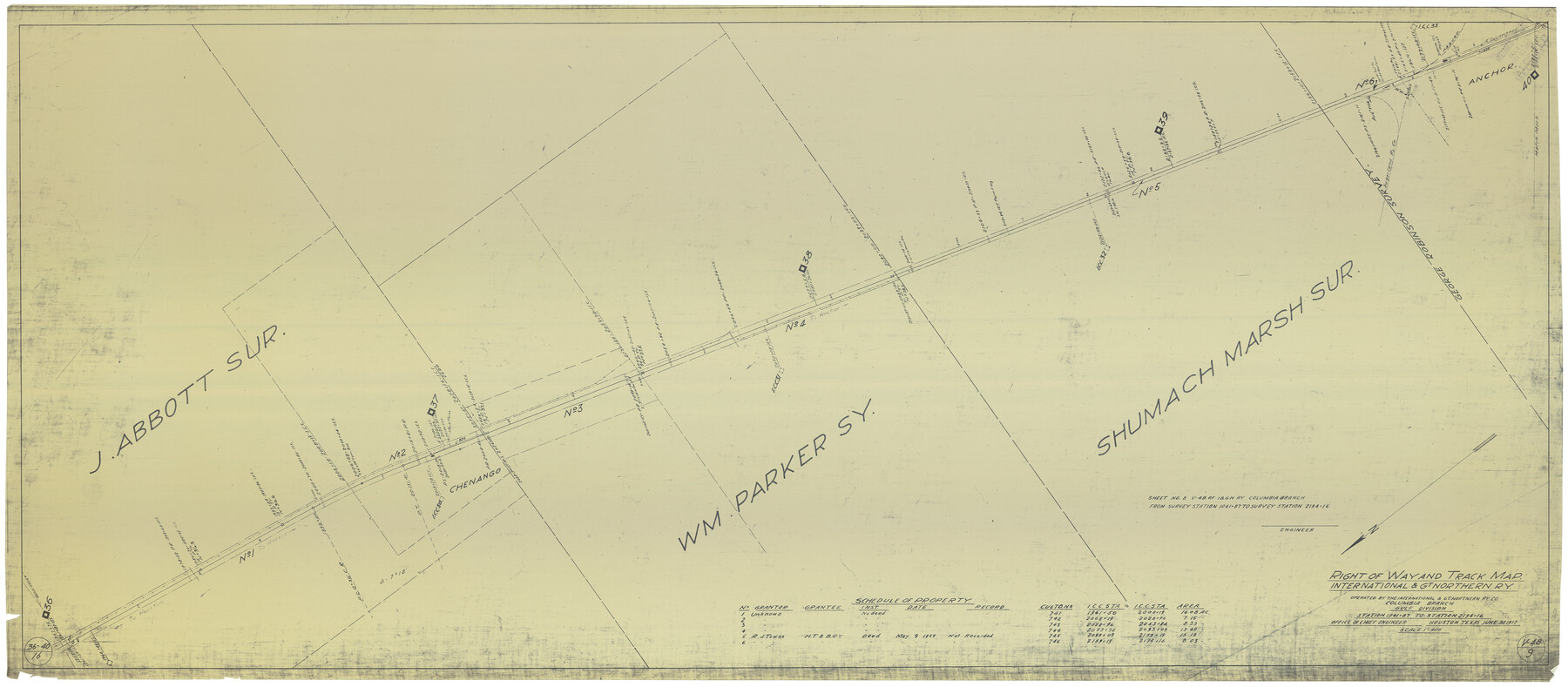
Right of Way and Track Map International & Gt. Northern Ry. operated by the International & Gt. Northern Ry. Co., Columbia Branch, Gulf Division
Station 1961+87 to Station 2194+16
Z-2-184
-
Map/Doc
64596
-
Collection
General Map Collection
-
Object Dates
6/30/1917 (Creation Date)
-
Counties
Brazoria
-
Subjects
Railroads
-
Height x Width
25.1 x 56.4 inches
63.8 x 143.3 cm
-
Medium
blueprint/diazo
-
Scale
1" = 400 feet
-
Comments
See counter nos. 64594 through 64595 and 64597 through 64601 for other sheets.
-
Features
I&GN
Sugar Land Railway
Anchor
[Railroad line] to Anchor
Chenango
[Railroad line] to Houston
Part of: General Map Collection
Outer Continental Shelf Leasing Maps (Texas Offshore Operations)

Print $20.00
- Digital $50.00
Outer Continental Shelf Leasing Maps (Texas Offshore Operations)
Size 14.7 x 17.4 inches
Map/Doc 75845
Map of Texas and the Country Adjacent: Compiled in the Bureau of the Corps of Topographical Engineers from the best Authorities

Print $20.00
- Digital $50.00
Map of Texas and the Country Adjacent: Compiled in the Bureau of the Corps of Topographical Engineers from the best Authorities
1844
Size 17.0 x 23.4 inches
Map/Doc 95747
Wharton County

Print $40.00
- Digital $50.00
Wharton County
1946
Size 43.0 x 49.2 inches
Map/Doc 73321
Cochran County Rolled Sketch RM

Print $40.00
- Digital $50.00
Cochran County Rolled Sketch RM
1938
Size 29.4 x 107.6 inches
Map/Doc 8605
Flight Mission No. BRA-16M, Frame 57, Jefferson County

Print $20.00
- Digital $50.00
Flight Mission No. BRA-16M, Frame 57, Jefferson County
1953
Size 18.3 x 22.5 inches
Map/Doc 85674
Matagorda County Working Sketch Graphic Index, Sheet 2 (Sketches 17 to Most Recent)

Print $40.00
- Digital $50.00
Matagorda County Working Sketch Graphic Index, Sheet 2 (Sketches 17 to Most Recent)
1920
Size 40.1 x 48.6 inches
Map/Doc 76634

Lamar County Boundary File 56

Print $60.00
- Digital $50.00
Lamar County Boundary File 56
Size 8.7 x 6.4 inches
Map/Doc 56000
Railroad and County Map of Texas

Print $20.00
- Digital $50.00
Railroad and County Map of Texas
1906
Size 46.0 x 47.6 inches
Map/Doc 10748
La Salle County Sketch File 3

Print $44.00
- Digital $50.00
La Salle County Sketch File 3
1875
Size 15.8 x 29.6 inches
Map/Doc 11978
La Salle County Rolled Sketch 30

Print $20.00
- Digital $50.00
La Salle County Rolled Sketch 30
Size 30.1 x 40.8 inches
Map/Doc 6590
Motley County Sketch File 3A (N)

Print $20.00
- Digital $50.00
Motley County Sketch File 3A (N)
Size 12.3 x 17.5 inches
Map/Doc 42136
You may also like
Galveston County Sketch File 2a

Print $4.00
- Digital $50.00
Galveston County Sketch File 2a
1848
Size 14.3 x 8.8 inches
Map/Doc 23350
Washington County

Print $20.00
- Digital $50.00
Washington County
1871
Size 11.9 x 27.7 inches
Map/Doc 4123
General Highway Map, Hutchinson County, Texas

Print $20.00
General Highway Map, Hutchinson County, Texas
1961
Size 18.1 x 24.6 inches
Map/Doc 79529
Pecos County Rolled Sketch 129

Print $40.00
- Digital $50.00
Pecos County Rolled Sketch 129
1948
Size 42.9 x 52.4 inches
Map/Doc 9727
Upton County Working Sketch 15

Print $40.00
- Digital $50.00
Upton County Working Sketch 15
1940
Size 28.4 x 48.6 inches
Map/Doc 69511
Maps of Gulf Intracoastal Waterway, Texas - Sabine River to the Rio Grande and connecting waterways including ship channels

Print $20.00
- Digital $50.00
Maps of Gulf Intracoastal Waterway, Texas - Sabine River to the Rio Grande and connecting waterways including ship channels
1966
Size 14.3 x 20.7 inches
Map/Doc 61998
New Map of the State of Texas Compiled from J. De Cordova's large Map

Print $20.00
- Digital $50.00
New Map of the State of Texas Compiled from J. De Cordova's large Map
1856
Size 17.8 x 27.4 inches
Map/Doc 89252
The Judicial District/County of Ward. Abolished, Spring 1842

Print $20.00
The Judicial District/County of Ward. Abolished, Spring 1842
2020
Size 18.7 x 21.7 inches
Map/Doc 96355
Flight Mission No. DQO-2K, Frame 142, Galveston County

Print $20.00
- Digital $50.00
Flight Mission No. DQO-2K, Frame 142, Galveston County
1952
Size 18.8 x 22.4 inches
Map/Doc 85039
Jefferson County Rolled Sketch 22

Print $92.00
- Digital $50.00
Jefferson County Rolled Sketch 22
1936
Size 20.4 x 73.1 inches
Map/Doc 9287

[North part of G. C. & S. F. Block OP, Runnels County School Land and Blks. AB, CD and GH]
![90310, [North part of G. C. & S. F. Block OP, Runnels County School Land and Blks. AB, CD and GH], Twichell Survey Records](https://historictexasmaps.com/wmedia_w700/maps/90310-1.tif.jpg)
Print $20.00
- Digital $50.00
[North part of G. C. & S. F. Block OP, Runnels County School Land and Blks. AB, CD and GH]
Size 17.5 x 22.4 inches
Map/Doc 90310