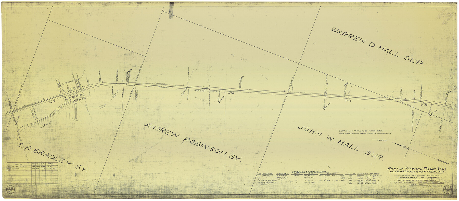
Right of Way and Track Map International & Gt. Northern Ry. operated by the International & Gt. Northern Ry. Co., Columbia Branch, Gulf Division
Station 1544+09 to Station 1762+06
Z-2-184
-
Map/Doc
64598
-
Collection
General Map Collection
-
Object Dates
6/30/1917 (Creation Date)
3/5/1927 (Revision Date)
10/27/1930 (Revision Date)
-
People and Organizations
J. F. H. (Draftsman)
-
Counties
Brazoria
-
Subjects
Railroads
-
Height x Width
25.1 x 56.5 inches
63.8 x 143.5 cm
-
Medium
blueprint/diazo
-
Scale
1" = 400 feet
-
Comments
See counter nos. 64593 through 64597 and 64599 through 64601 for other sheets.
-
Features
I&GN
[Railroad line] to Houston
Rosharon
[Railroad line] to Anchor and East Columbia
Part of: General Map Collection
Chambers County Rolled Sketch 29

Print $20.00
- Digital $50.00
Chambers County Rolled Sketch 29
1951
Size 24.2 x 44.4 inches
Map/Doc 5429
Comanche County

Print $20.00
- Digital $50.00
Comanche County
1896
Size 39.4 x 44.2 inches
Map/Doc 4734
Concho County Sketch File 42

Print $8.00
- Digital $50.00
Concho County Sketch File 42
1948
Size 14.4 x 8.9 inches
Map/Doc 19200
Pecos County Sketch File 86

Print $22.00
- Digital $50.00
Pecos County Sketch File 86
1917
Size 13.4 x 9.0 inches
Map/Doc 33964
Flight Mission No. DCL-7C, Frame 4, Kenedy County

Print $20.00
- Digital $50.00
Flight Mission No. DCL-7C, Frame 4, Kenedy County
1943
Size 18.6 x 22.3 inches
Map/Doc 85996
Oldham County Sketch File 9a

Print $4.00
- Digital $50.00
Oldham County Sketch File 9a
1886
Size 14.2 x 8.7 inches
Map/Doc 33241
Flight Mission No. CRC-3R, Frame 41, Chambers County

Print $20.00
- Digital $50.00
Flight Mission No. CRC-3R, Frame 41, Chambers County
1956
Size 18.6 x 22.2 inches
Map/Doc 84814
Webb County Working Sketch 60

Print $20.00
- Digital $50.00
Webb County Working Sketch 60
1960
Size 43.3 x 47.8 inches
Map/Doc 72426
Atascosa County Sketch File 1

Print $8.00
- Digital $50.00
Atascosa County Sketch File 1
Size 8.1 x 6.1 inches
Map/Doc 13718
Zavala County Working Sketch 21

Print $20.00
- Digital $50.00
Zavala County Working Sketch 21
1979
Size 23.0 x 18.0 inches
Map/Doc 62096
Right of Way and Track Map, the Missouri, Kansas and Texas Ry. of Texas - Henrietta Division

Print $20.00
- Digital $50.00
Right of Way and Track Map, the Missouri, Kansas and Texas Ry. of Texas - Henrietta Division
1918
Size 11.8 x 27.0 inches
Map/Doc 64761
Flight Mission No. BRA-7M, Frame 194, Jefferson County

Print $20.00
- Digital $50.00
Flight Mission No. BRA-7M, Frame 194, Jefferson County
1953
Size 18.5 x 22.3 inches
Map/Doc 85562
You may also like
Andrews County Working Sketch 9

Print $20.00
- Digital $50.00
Andrews County Working Sketch 9
1955
Size 10.2 x 23.3 inches
Map/Doc 67055
General Highway Map, Cooke County, Texas

Print $20.00
General Highway Map, Cooke County, Texas
1961
Size 24.8 x 18.2 inches
Map/Doc 79421

El Paso County Working Sketch 31

Print $20.00
- Digital $50.00
El Paso County Working Sketch 31
1970
Size 30.9 x 26.0 inches
Map/Doc 69053
Leon County Rolled Sketch 36

Print $20.00
- Digital $50.00
Leon County Rolled Sketch 36
Size 18.1 x 24.0 inches
Map/Doc 95352
Bexar County Working Sketch 22

Print $20.00
- Digital $50.00
Bexar County Working Sketch 22
1986
Size 16.3 x 16.1 inches
Map/Doc 67338

Jones County Sketch File 2

Print $20.00
- Digital $50.00
Jones County Sketch File 2
1857
Size 16.8 x 21.1 inches
Map/Doc 11895
Map of McLennan Co[unty]
![88974, Map of McLennan Co[unty], Library of Congress](https://historictexasmaps.com/wmedia_w700/maps/88974.tif.jpg)
Print $40.00
Map of McLennan Co[unty]
1896
Size 47.9 x 53.6 inches
Map/Doc 88974
Flight Mission No. CRC-4R, Frame 160, Chambers County

Print $20.00
- Digital $50.00
Flight Mission No. CRC-4R, Frame 160, Chambers County
1956
Size 18.5 x 22.3 inches
Map/Doc 84919
Routes to HemisFair '68 : World's Fair, San Antonio, Texas, April 6 through Oct. 6, 1968 [Verso]
![94169, Hemisfair Gulf Tourgide Map [Verso], General Map Collection](https://historictexasmaps.com/wmedia_w700/maps/94169.tif.jpg)
Routes to HemisFair '68 : World's Fair, San Antonio, Texas, April 6 through Oct. 6, 1968 [Verso]
Size 18.3 x 24.3 inches
Map/Doc 94169
Newton County Sketch File 38

Print $6.00
- Digital $50.00
Newton County Sketch File 38
Size 16.1 x 11.0 inches
Map/Doc 32417