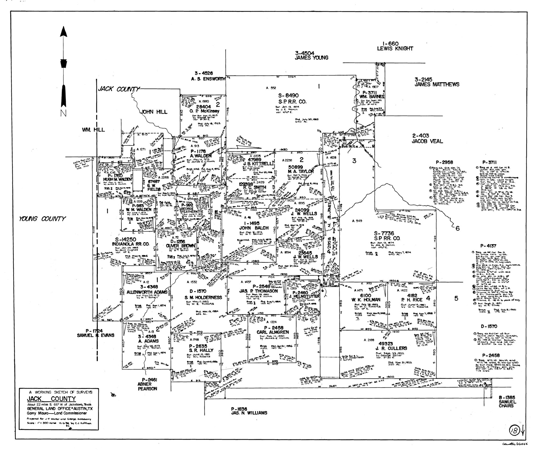
Jack County Working Sketch 18
-
Map/Doc
66444
-
Collection
General Map Collection
-
Object Dates
12/31/1986 (Creation Date)
-
People and Organizations
Huffman, Cynthia J. (Draftsman)
-
Counties
Jack
-
Subjects
Surveying Working Sketch
-
Height x Width
29.8 x 35.5 inches
75.7 x 90.2 cm
-
Scale
1" = 300 varas
Part of: General Map Collection
Flight Mission No. CGI-4N, Frame 30, Cameron County

Print $20.00
- Digital $50.00
Flight Mission No. CGI-4N, Frame 30, Cameron County
1954
Size 18.6 x 22.3 inches
Map/Doc 84663
Map of Nacogdoches County

Print $20.00
- Digital $50.00
Map of Nacogdoches County
1881
Size 25.2 x 20.7 inches
Map/Doc 4601
Coryell County Sketch File 20

Print $20.00
- Digital $50.00
Coryell County Sketch File 20
Size 25.8 x 20.1 inches
Map/Doc 11183
Cooke County Sketch File 12

Print $4.00
- Digital $50.00
Cooke County Sketch File 12
Size 10.1 x 8.3 inches
Map/Doc 19246
Stephens County

Print $20.00
- Digital $50.00
Stephens County
1940
Size 42.9 x 41.0 inches
Map/Doc 63045
Brazoria County Rolled Sketch 29

Print $20.00
- Digital $50.00
Brazoria County Rolled Sketch 29
1931
Size 41.4 x 29.1 inches
Map/Doc 5167
Val Verde County Working Sketch 38

Print $20.00
- Digital $50.00
Val Verde County Working Sketch 38
1943
Size 14.8 x 18.9 inches
Map/Doc 72173
Denton County Sketch File 11

Print $4.00
- Digital $50.00
Denton County Sketch File 11
1856
Size 5.1 x 8.6 inches
Map/Doc 20709
Flight Mission No. CRC-3R, Frame 105, Chambers County

Print $20.00
- Digital $50.00
Flight Mission No. CRC-3R, Frame 105, Chambers County
1956
Size 18.8 x 22.4 inches
Map/Doc 84843

Map of Texas from the most recent authorities

Map of Texas from the most recent authorities
1845
Size 11.2 x 17.2 inches
Map/Doc 4333
Terry County Boundary File 1

Print $4.00
- Digital $50.00
Terry County Boundary File 1
Size 11.6 x 9.0 inches
Map/Doc 59202
You may also like
Lee County Working Sketch 6

Print $20.00
- Digital $50.00
Lee County Working Sketch 6
1975
Size 39.7 x 36.3 inches
Map/Doc 70385
Lampasas County Working Sketch 24

Print $20.00
- Digital $50.00
Lampasas County Working Sketch 24
Size 14.3 x 13.3 inches
Map/Doc 61796
Milam County Rolled Sketch 3C

Print $20.00
- Digital $50.00
Milam County Rolled Sketch 3C
1959
Size 21.8 x 18.4 inches
Map/Doc 6776
Coleman County Sketch File 15

Print $4.00
- Digital $50.00
Coleman County Sketch File 15
1848
Size 7.3 x 13.0 inches
Map/Doc 18681
Wichita County Sketch File 13

Print $22.00
- Digital $50.00
Wichita County Sketch File 13
Size 7.9 x 10.6 inches
Map/Doc 40082
Tom Green County Rolled Sketch 5

Print $20.00
- Digital $50.00
Tom Green County Rolled Sketch 5
1947
Size 44.9 x 35.0 inches
Map/Doc 9997
Terrell County Rolled Sketch 26

Print $20.00
- Digital $50.00
Terrell County Rolled Sketch 26
1914
Size 17.3 x 15.2 inches
Map/Doc 7933
Duval County Sketch File 85

Print $27.00
- Digital $50.00
Duval County Sketch File 85
1935
Size 14.3 x 9.1 inches
Map/Doc 21534
Maverick County Sketch File 3a

Print $34.00
- Digital $50.00
Maverick County Sketch File 3a
Size 10.0 x 8.0 inches
Map/Doc 31035
Clay County Sketch File 28

Print $20.00
- Digital $50.00
Clay County Sketch File 28
Size 25.3 x 31.2 inches
Map/Doc 11090
[De Loches County School Land]
![91198, [De Loches County School Land], Twichell Survey Records](https://historictexasmaps.com/wmedia_w700/maps/91198-1.tif.jpg)
Print $20.00
- Digital $50.00
[De Loches County School Land]
Size 20.4 x 35.2 inches
Map/Doc 91198
