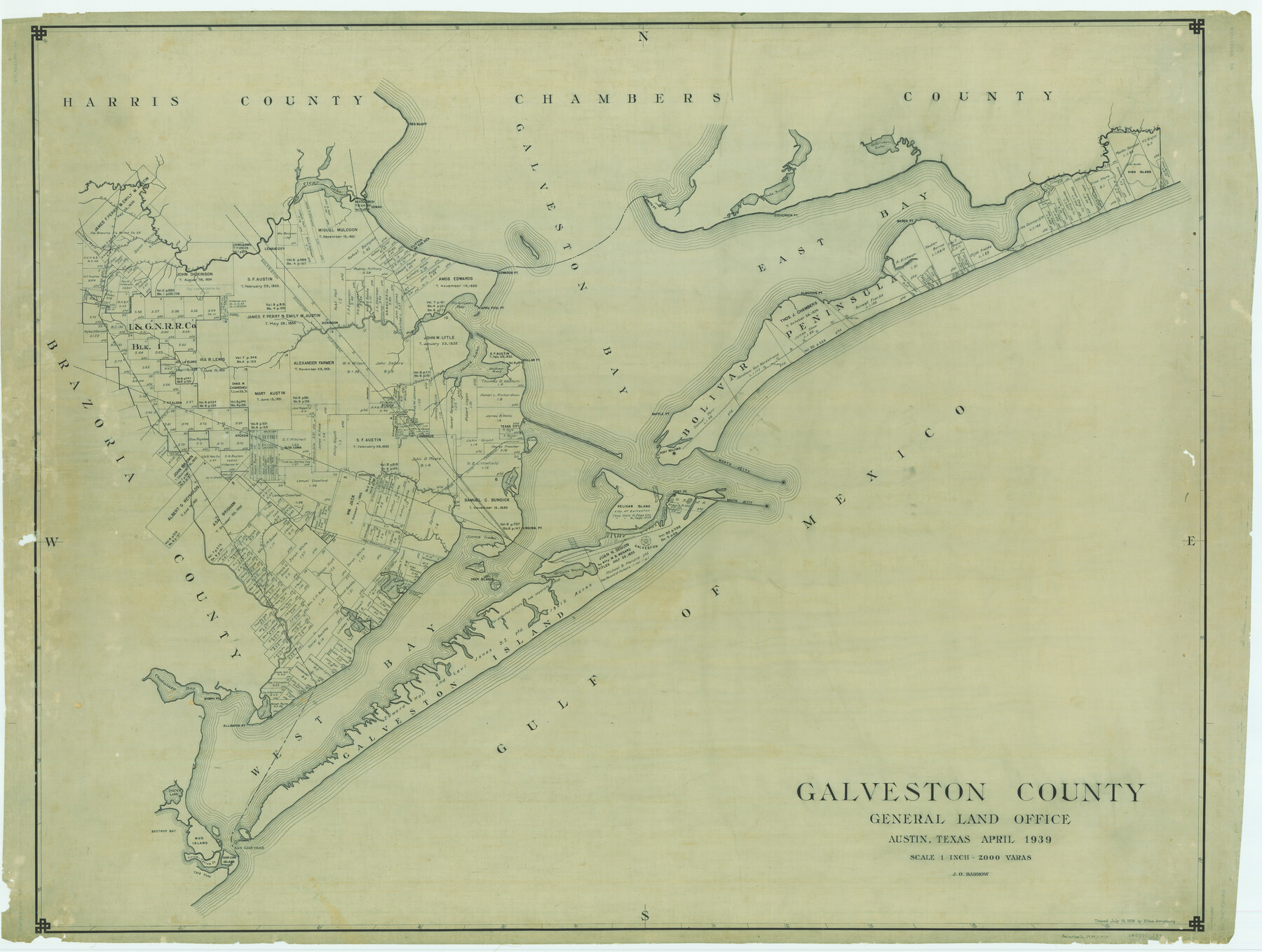
Galveston County
-
Map/Doc
66835
-
Collection
General Map Collection
-
Object Dates
1939 (Creation Date)
-
People and Organizations
Texas General Land Office (Publisher)
J.O. Barrow (Draftsman)
J.O. Barrow (Compiler)
-
Counties
Galveston
-
Subjects
County
-
Height x Width
44.6 x 59.1 inches
113.3 x 150.1 cm
-
Comments
Traced July 13, 1939 by Eltea Armstrong.
Part of: General Map Collection
Reeves County Sketch File 18

Print $40.00
- Digital $50.00
Reeves County Sketch File 18
1926
Size 22.2 x 9.4 inches
Map/Doc 35210
Frio County Rolled Sketch HM2

Print $20.00
- Digital $50.00
Frio County Rolled Sketch HM2
1935
Size 41.3 x 30.6 inches
Map/Doc 8899
Comanche County Working Sketch 32

Print $20.00
- Digital $50.00
Comanche County Working Sketch 32
1992
Size 23.5 x 38.8 inches
Map/Doc 68166
Roberts County Working Sketch 1

Print $20.00
- Digital $50.00
Roberts County Working Sketch 1
1922
Size 17.6 x 17.7 inches
Map/Doc 63527
Map of a Route from Austin-City to Paso del Norte & c.

Print $20.00
- Digital $50.00
Map of a Route from Austin-City to Paso del Norte & c.
1849
Size 11.7 x 30.5 inches
Map/Doc 2121
Montgomery County Working Sketch 6

Print $20.00
- Digital $50.00
Montgomery County Working Sketch 6
1932
Size 24.8 x 32.2 inches
Map/Doc 71112
Randall County Working Sketch Graphic Index

Print $20.00
- Digital $50.00
Randall County Working Sketch Graphic Index
1958
Size 41.2 x 33.2 inches
Map/Doc 76676
Flight Mission No. BQY-4M, Frame 67, Harris County

Print $20.00
- Digital $50.00
Flight Mission No. BQY-4M, Frame 67, Harris County
1953
Size 18.7 x 22.4 inches
Map/Doc 85276
Deaf Smith Co.

Print $20.00
- Digital $50.00
Deaf Smith Co.
1910
Size 20.2 x 28.1 inches
Map/Doc 1767
Galveston County Rolled Sketch 14

Print $155.00
- Digital $50.00
Galveston County Rolled Sketch 14
1950
Size 10.1 x 15.3 inches
Map/Doc 44808
Flight Mission No. BRE-2P, Frame 73, Nueces County

Print $20.00
- Digital $50.00
Flight Mission No. BRE-2P, Frame 73, Nueces County
1956
Size 18.5 x 22.5 inches
Map/Doc 86768
Aransas County NRC Article 33.136 Sketch 10

Print $26.00
- Digital $50.00
Aransas County NRC Article 33.136 Sketch 10
Size 24.2 x 36.0 inches
Map/Doc 95016
You may also like
Andrews County Working Sketch 30

Print $40.00
- Digital $50.00
Andrews County Working Sketch 30
1989
Size 34.2 x 48.0 inches
Map/Doc 67076
Plat in Pecos County, Texas

Print $20.00
- Digital $50.00
Plat in Pecos County, Texas
Size 32.8 x 23.2 inches
Map/Doc 91613
Anderson County Sketch File 22

Print $40.00
- Digital $50.00
Anderson County Sketch File 22
1925
Size 38.0 x 37.5 inches
Map/Doc 10315
Wilbarger County Boundary File 1

Print $52.00
- Digital $50.00
Wilbarger County Boundary File 1
Size 8.9 x 5.6 inches
Map/Doc 59916
Val Verde County Working Sketch 90

Print $40.00
- Digital $50.00
Val Verde County Working Sketch 90
1974
Size 49.1 x 32.9 inches
Map/Doc 72225
Presidio County Sketch File 103

Print $24.00
- Digital $50.00
Presidio County Sketch File 103
1949
Size 14.4 x 8.8 inches
Map/Doc 34795
Matagorda Light to Aransas Pass

Print $20.00
- Digital $50.00
Matagorda Light to Aransas Pass
1961
Size 35.9 x 44.7 inches
Map/Doc 73396
General Highway Map, Presidio County, Texas

Print $20.00
General Highway Map, Presidio County, Texas
1961
Size 24.5 x 18.3 inches
Map/Doc 79633


Mexico and Internal Provinces

Print $20.00
Mexico and Internal Provinces
1822
Size 17.8 x 22.5 inches
Map/Doc 76189
Montgomery County Rolled Sketch 42

Print $20.00
- Digital $50.00
Montgomery County Rolled Sketch 42
1939
Size 13.9 x 20.1 inches
Map/Doc 6819