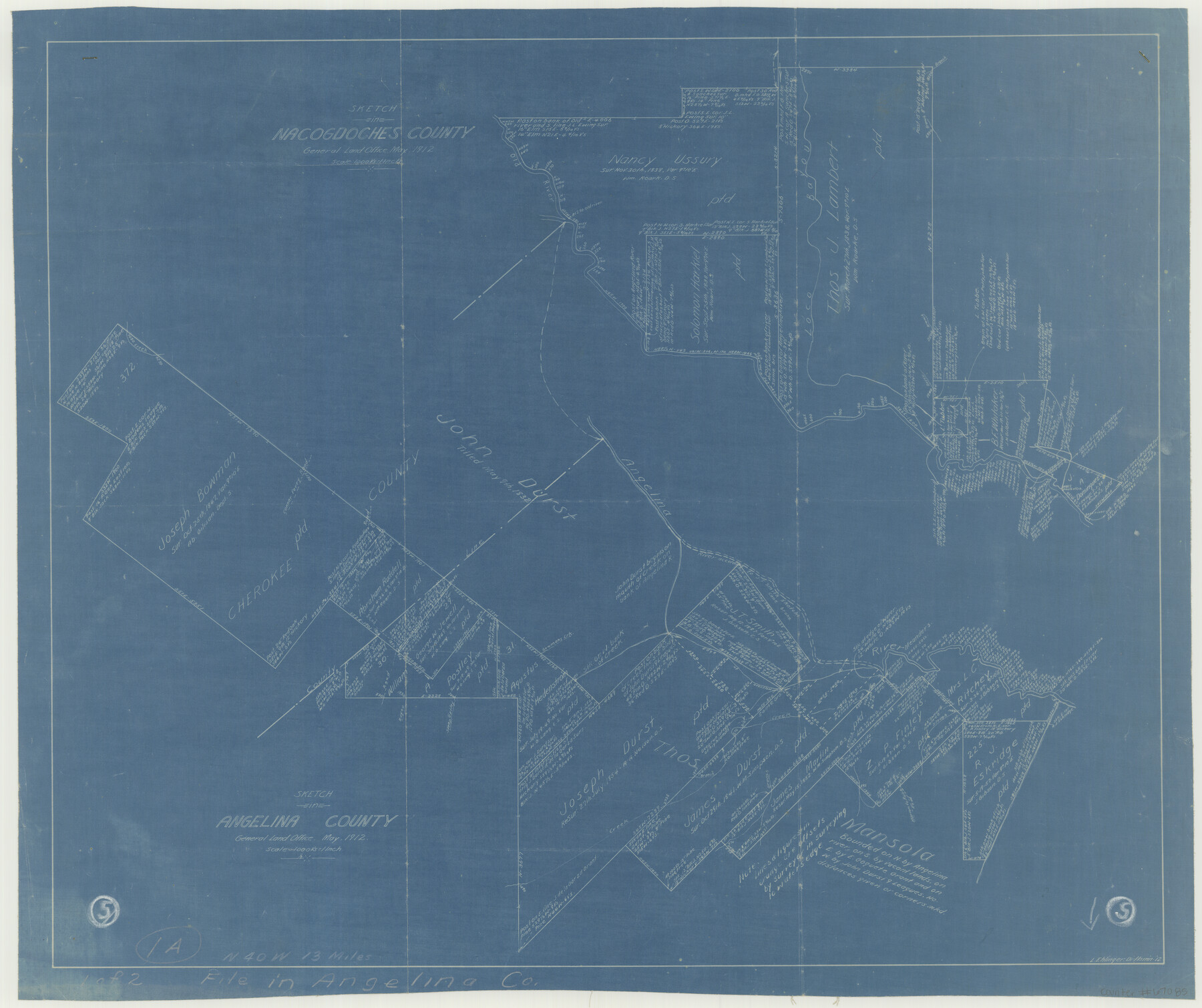
Angelina County Working Sketch 5
-
Map/Doc
67085
-
Collection
General Map Collection
-
Object Dates
5/1912 (Creation Date)
-
People and Organizations
L. Ehlinger (Draftsman)
-
Counties
Angelina Nacogdoches Cherokee
-
Subjects
Surveying Working Sketch
-
Height x Width
22.0 x 26.2 inches
55.9 x 66.6 cm
-
Scale
1" = 1000 varas
-
Comments
Surveys located about 13 miles North 40 degrees West from Lufkin, Texas.
Part of: General Map Collection
Jefferson County Rolled Sketch 57

Print $20.00
- Digital $50.00
Jefferson County Rolled Sketch 57
1883
Size 18.6 x 25.9 inches
Map/Doc 6409
Flight Mission No. DQN-3K, Frame 12, Calhoun County

Print $20.00
- Digital $50.00
Flight Mission No. DQN-3K, Frame 12, Calhoun County
1953
Size 18.8 x 22.4 inches
Map/Doc 84344
Erath County Working Sketch 4

Print $20.00
- Digital $50.00
Erath County Working Sketch 4
1919
Size 31.7 x 28.6 inches
Map/Doc 69085
El Paso County Rolled Sketch 52

Print $20.00
- Digital $50.00
El Paso County Rolled Sketch 52
1960
Size 18.4 x 24.4 inches
Map/Doc 5841
Presidio County Rolled Sketch 76

Print $20.00
- Digital $50.00
Presidio County Rolled Sketch 76
Size 24.3 x 36.4 inches
Map/Doc 9777
Colorado River, Sandy Creek Sheet

Print $6.00
- Digital $50.00
Colorado River, Sandy Creek Sheet
1941
Size 27.5 x 30.7 inches
Map/Doc 65319
Midland County Rolled Sketch 2

Print $20.00
- Digital $50.00
Midland County Rolled Sketch 2
1949
Size 39.3 x 36.5 inches
Map/Doc 9513
Madison County

Print $20.00
- Digital $50.00
Madison County
1871
Size 14.0 x 19.6 inches
Map/Doc 3833
Blanco County Sketch File 21b

Print $40.00
- Digital $50.00
Blanco County Sketch File 21b
1882
Size 16.9 x 17.8 inches
Map/Doc 10930
Trinity County Working Sketch 1

Print $20.00
- Digital $50.00
Trinity County Working Sketch 1
1904
Size 17.1 x 12.3 inches
Map/Doc 69449
Polk County Sketch File 8

Print $4.00
- Digital $50.00
Polk County Sketch File 8
1859
Size 10.9 x 8.4 inches
Map/Doc 34134
Flight Mission No. DAG-26K, Frame 64, Matagorda County

Print $20.00
- Digital $50.00
Flight Mission No. DAG-26K, Frame 64, Matagorda County
1953
Size 18.5 x 22.2 inches
Map/Doc 86584
You may also like
Cherokee County

Print $40.00
- Digital $50.00
Cherokee County
1933
Size 57.0 x 38.8 inches
Map/Doc 77236
North Sulphur River, Bartley Gin Sheet

Print $20.00
- Digital $50.00
North Sulphur River, Bartley Gin Sheet
1928
Size 13.3 x 22.0 inches
Map/Doc 78323
Hardin County Working Sketch 34

Print $20.00
- Digital $50.00
Hardin County Working Sketch 34
1980
Size 15.7 x 12.1 inches
Map/Doc 63432
Howard County Sketch File 4

Print $20.00
- Digital $50.00
Howard County Sketch File 4
Size 25.6 x 21.8 inches
Map/Doc 11793
[Sketch for Mineral Application 13439 - Bed Lost Lake, Walle Merritt]
![65577, [Sketch for Mineral Application 13439 - Bed Lost Lake, Walle Merritt], General Map Collection](https://historictexasmaps.com/wmedia_w700/maps/65577.tif.jpg)
Print $20.00
- Digital $50.00
[Sketch for Mineral Application 13439 - Bed Lost Lake, Walle Merritt]
1925
Size 31.1 x 29.9 inches
Map/Doc 65577
Map Showing East Part Pecos County, Texas with Blocks 194 and 178 Constructed and Adjusted to the Ground Distance from NE 36 Block 12 H&GN to Pecos Spring and by Original Field Note Calls from Pecos Spring to NE 75 Blk. 1 I&GN

Print $40.00
- Digital $50.00
Map Showing East Part Pecos County, Texas with Blocks 194 and 178 Constructed and Adjusted to the Ground Distance from NE 36 Block 12 H&GN to Pecos Spring and by Original Field Note Calls from Pecos Spring to NE 75 Blk. 1 I&GN
Size 45.0 x 51.4 inches
Map/Doc 89838
[Sections Q, L Tech Memorial Park]
![92303, [Sections Q, L Tech Memorial Park], Twichell Survey Records](https://historictexasmaps.com/wmedia_w700/maps/92303-1.tif.jpg)
Print $20.00
- Digital $50.00
[Sections Q, L Tech Memorial Park]
1956
Size 13.0 x 17.8 inches
Map/Doc 92303
Map of Navarro County, Texas

Print $20.00
- Digital $50.00
Map of Navarro County, Texas
1871
Size 23.5 x 28.7 inches
Map/Doc 662
Oldham County Sketch File 20

Print $6.00
- Digital $50.00
Oldham County Sketch File 20
1916
Size 11.1 x 8.5 inches
Map/Doc 33275
Castro County Sketch File 4f

Print $4.00
- Digital $50.00
Castro County Sketch File 4f
Size 13.8 x 8.9 inches
Map/Doc 17475
Map showing the Distribution of Slaves in the Southern States

Print $20.00
- Digital $50.00
Map showing the Distribution of Slaves in the Southern States
1861
Size 15.2 x 18.3 inches
Map/Doc 96634
Santa Fe Lines - Texas, Oklahoma, and Louisiana

Print $20.00
- Digital $50.00
Santa Fe Lines - Texas, Oklahoma, and Louisiana
1923
Size 9.3 x 8.3 inches
Map/Doc 96595