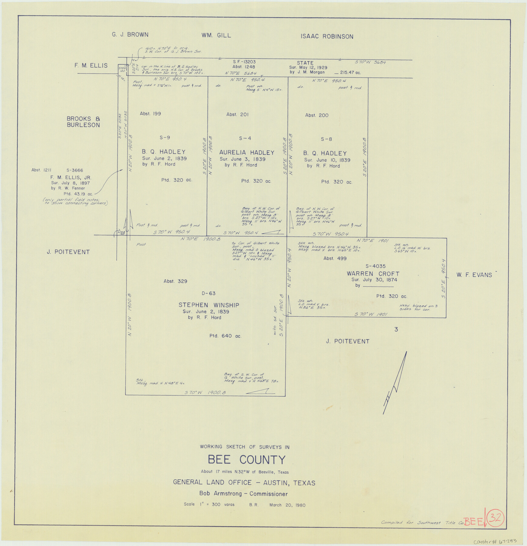
Bee County Working Sketch 32
-
Map/Doc
67283
-
Collection
General Map Collection
-
Object Dates
3/20/1980 (Creation Date)
-
People and Organizations
Bob Armstrong (GLO Commissioner)
Beverly Robison (Draftsman)
-
Counties
Bee
-
Subjects
Surveying Working Sketch
-
Height x Width
21.7 x 21.0 inches
55.1 x 53.3 cm
-
Scale
1" = 300 varas
-
Comments
Surveys located about 17 miles North 32 degrees West of Beeville, Texas.
Part of: General Map Collection
Webb County Sketch File 5

Print $8.00
- Digital $50.00
Webb County Sketch File 5
1876
Size 12.8 x 8.1 inches
Map/Doc 39725
Dallas County Sketch File 3

Print $20.00
- Digital $50.00
Dallas County Sketch File 3
1855
Size 22.4 x 14.0 inches
Map/Doc 11282
Kent County Boundary File 12

Print $30.00
- Digital $50.00
Kent County Boundary File 12
Size 10.5 x 8.2 inches
Map/Doc 55897
Oldham County

Print $40.00
- Digital $50.00
Oldham County
1925
Size 42.6 x 51.5 inches
Map/Doc 77387
Flight Mission No. CGI-3N, Frame 187, Cameron County

Print $20.00
- Digital $50.00
Flight Mission No. CGI-3N, Frame 187, Cameron County
1954
Size 18.5 x 22.2 inches
Map/Doc 84651
Kleberg County Rolled Sketch 10-36

Print $20.00
- Digital $50.00
Kleberg County Rolled Sketch 10-36
1952
Size 35.3 x 30.7 inches
Map/Doc 9382
Marion County Sketch File 16

Print $20.00
- Digital $50.00
Marion County Sketch File 16
1954
Size 22.9 x 23.2 inches
Map/Doc 12025
Flight Mission No. CRC-2R, Frame 134, Chambers County

Print $20.00
- Digital $50.00
Flight Mission No. CRC-2R, Frame 134, Chambers County
1956
Size 18.6 x 22.3 inches
Map/Doc 84750

Dawson County Sketch File 15

Print $40.00
- Digital $50.00
Dawson County Sketch File 15
Size 17.8 x 7.9 inches
Map/Doc 20549
Val Verde County Sketch File 47

Print $20.00
- Digital $50.00
Val Verde County Sketch File 47
1951
Size 25.1 x 18.7 inches
Map/Doc 12588
Bowie County Working Sketch 22

Print $40.00
- Digital $50.00
Bowie County Working Sketch 22
1968
Size 49.0 x 37.8 inches
Map/Doc 67426
You may also like
Val Verde County Working Sketch 118

Print $40.00
- Digital $50.00
Val Verde County Working Sketch 118
2005
Size 29.6 x 50.0 inches
Map/Doc 83587
Culberson County Working Sketch 23a

Print $20.00
- Digital $50.00
Culberson County Working Sketch 23a
1947
Size 32.1 x 46.4 inches
Map/Doc 68475
Hidalgo County Sketch File 7a

Print $4.00
- Digital $50.00
Hidalgo County Sketch File 7a
1886
Size 12.8 x 8.2 inches
Map/Doc 26405
Midland County Boundary File 4a

Print $40.00
- Digital $50.00
Midland County Boundary File 4a
Size 36.2 x 54.5 inches
Map/Doc 57185
Map showing lands surveyed by Sylvan Sanders in the Southwestern Part of Jack County, Texas for Buttram Petroleum Corporation

Print $20.00
- Digital $50.00
Map showing lands surveyed by Sylvan Sanders in the Southwestern Part of Jack County, Texas for Buttram Petroleum Corporation
1926
Size 29.3 x 25.6 inches
Map/Doc 92159
Kerr County Working Sketch 11

Print $20.00
- Digital $50.00
Kerr County Working Sketch 11
1951
Size 30.3 x 29.9 inches
Map/Doc 70042
Flight Mission No. DQO-8K, Frame 15, Galveston County

Print $20.00
- Digital $50.00
Flight Mission No. DQO-8K, Frame 15, Galveston County
1952
Size 18.7 x 22.4 inches
Map/Doc 85138
[Texas & Pacific Railway, Longview to Dallas]
![64098, [Texas & Pacific Railway, Longview to Dallas], General Map Collection](https://historictexasmaps.com/wmedia_w700/maps/64098.tif.jpg)
Print $40.00
- Digital $50.00
[Texas & Pacific Railway, Longview to Dallas]
1873
Size 14.5 x 121.6 inches
Map/Doc 64098
Map of the Harlem State Farm and the Central State Farm, Fort Bend County, Texas

Print $20.00
- Digital $50.00
Map of the Harlem State Farm and the Central State Farm, Fort Bend County, Texas
Size 35.7 x 32.1 inches
Map/Doc 62995
Collin County Sketch File 9

Print $4.00
- Digital $50.00
Collin County Sketch File 9
1878
Size 8.3 x 10.1 inches
Map/Doc 18870
Hoffman & Walker's Pictorial, Historical Map of Texas

Hoffman & Walker's Pictorial, Historical Map of Texas
1960
Size 43.4 x 45.3 inches
Map/Doc 93275
Fort Bend County Working Sketch 25

Print $40.00
- Digital $50.00
Fort Bend County Working Sketch 25
1981
Size 43.7 x 65.9 inches
Map/Doc 69231