Menard County Rolled Sketch 9
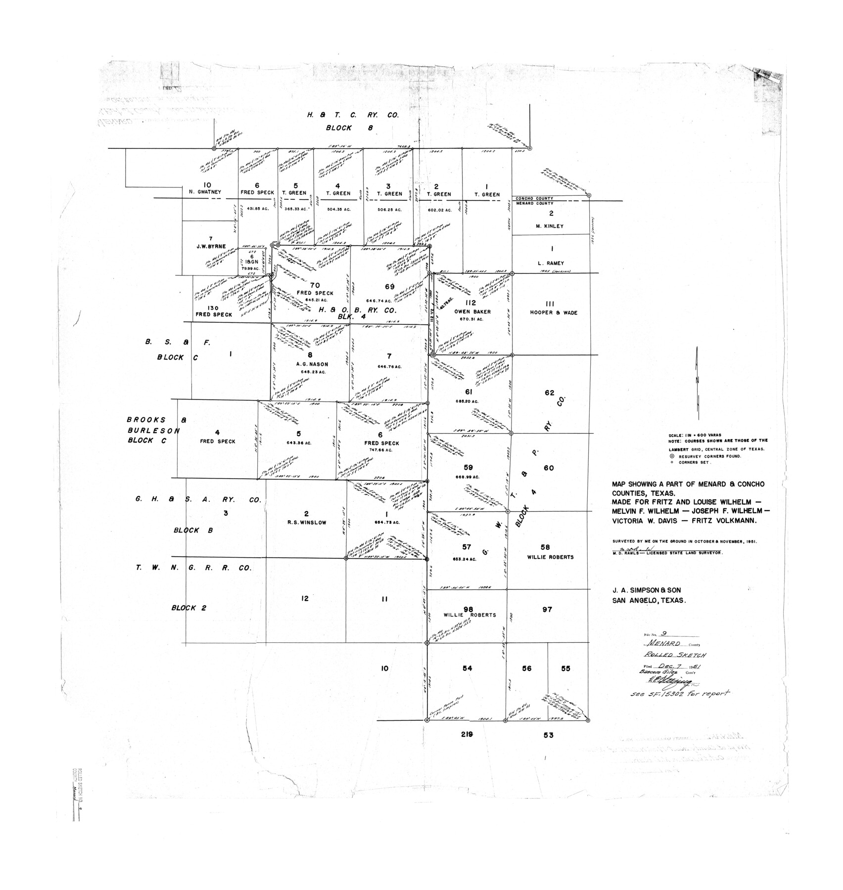
Map showing a part of Menard & Concho Counties, Texas made for Fritz and Louise Wilhelm - Melvin F. Wilhelm - Joseph F. Wilhelm - Victoria W. Davis - Fritz Volkmann
-
Map/Doc
6756
-
Collection
General Map Collection
-
Object Dates
1951 (Survey Date)
1951/12/7 (File Date)
-
People and Organizations
M.D. Rawls (Surveyor/Engineer)
-
Counties
Menard Concho
-
Subjects
Surveying Rolled Sketch
-
Height x Width
36.0 x 34.1 inches
91.4 x 86.6 cm
-
Scale
1" = 600 varas
-
Comments
See SF-15302 for report.
Part of: General Map Collection
Tyler County Rolled Sketch 9

Print $20.00
- Digital $50.00
Tyler County Rolled Sketch 9
Size 43.3 x 25.6 inches
Map/Doc 8059
[Capitol Lands in Dallam, Hartley, Oldham, Deaf Smith, Parmer, Bailey, Lamb, Cochran, Castro, and Hockley Counties]
![60295, [Capitol Lands in Dallam, Hartley, Oldham, Deaf Smith, Parmer, Bailey, Lamb, Cochran, Castro, and Hockley Counties], General Map Collection](https://historictexasmaps.com/wmedia_w700/maps/60295.tif.jpg)
Print $40.00
- Digital $50.00
[Capitol Lands in Dallam, Hartley, Oldham, Deaf Smith, Parmer, Bailey, Lamb, Cochran, Castro, and Hockley Counties]
Size 55.4 x 22.0 inches
Map/Doc 60295
Hockley County

Print $20.00
- Digital $50.00
Hockley County
1954
Size 44.2 x 39.7 inches
Map/Doc 95531
Working Sketch No. IV in Pecos County

Print $20.00
- Digital $50.00
Working Sketch No. IV in Pecos County
1886
Size 36.7 x 23.6 inches
Map/Doc 3954
[Portion of Harrison County]
![78366, [Portion of Harrison County], General Map Collection](https://historictexasmaps.com/wmedia_w700/maps/78366.tif.jpg)
Print $3.00
- Digital $50.00
[Portion of Harrison County]
1841
Size 15.7 x 11.6 inches
Map/Doc 78366
El Paso County Working Sketch 12

Print $20.00
- Digital $50.00
El Paso County Working Sketch 12
1956
Size 33.0 x 41.4 inches
Map/Doc 69034
Brazoria County NRC Article 33.136 Sketch 8

Print $20.00
- Digital $50.00
Brazoria County NRC Article 33.136 Sketch 8
2006
Size 17.1 x 11.2 inches
Map/Doc 83649
Map of Navisota County

Print $20.00
- Digital $50.00
Map of Navisota County
Size 27.5 x 19.6 inches
Map/Doc 3328

[Surveys near Brushy Creek]
![361, [Surveys near Brushy Creek], General Map Collection](https://historictexasmaps.com/wmedia_w700/maps/361.tif.jpg)
Print $2.00
- Digital $50.00
[Surveys near Brushy Creek]
1846
Size 9.1 x 7.7 inches
Map/Doc 361
Harrison County Rolled Sketch 11

Print $20.00
- Digital $50.00
Harrison County Rolled Sketch 11
1957
Size 24.7 x 30.2 inches
Map/Doc 6154
Texas & Pacific Ry Reserve west of the Pecos River

Print $40.00
- Digital $50.00
Texas & Pacific Ry Reserve west of the Pecos River
1880
Size 43.9 x 90.6 inches
Map/Doc 3047
You may also like
Crane County Sketch File 20

Print $4.00
- Digital $50.00
Crane County Sketch File 20
1928
Size 14.4 x 9.0 inches
Map/Doc 19588
Medina County Rolled Sketch 4

Print $20.00
- Digital $50.00
Medina County Rolled Sketch 4
1943
Size 20.2 x 26.4 inches
Map/Doc 6740
Denison, Grayson County, Texas

Print $20.00
- Digital $50.00
Denison, Grayson County, Texas
1891
Size 23.7 x 35.7 inches
Map/Doc 97032
Flight Mission No. DQO-8K, Frame 65, Galveston County

Print $20.00
- Digital $50.00
Flight Mission No. DQO-8K, Frame 65, Galveston County
1952
Size 18.8 x 22.5 inches
Map/Doc 85169
Atascosa County Working Sketch 18

Print $20.00
- Digital $50.00
Atascosa County Working Sketch 18
1950
Size 43.2 x 25.8 inches
Map/Doc 67214
Pecos County Sketch File 47

Print $8.00
- Digital $50.00
Pecos County Sketch File 47
1935
Size 11.4 x 8.5 inches
Map/Doc 33759
Texas-Indian Territory Denison Quadrangle

Print $20.00
- Digital $50.00
Texas-Indian Territory Denison Quadrangle
1901
Size 20.1 x 16.7 inches
Map/Doc 75110
Fannin County Working Sketch 2

Print $3.00
- Digital $50.00
Fannin County Working Sketch 2
1911
Size 14.9 x 10.3 inches
Map/Doc 69156
Flight Mission No. DAG-18K, Frame 186, Matagorda County

Print $20.00
- Digital $50.00
Flight Mission No. DAG-18K, Frame 186, Matagorda County
1952
Size 17.2 x 22.5 inches
Map/Doc 86378
Jack County Working Sketch 21

Print $20.00
- Digital $50.00
Jack County Working Sketch 21
1993
Size 28.3 x 40.0 inches
Map/Doc 66447
Carson County Working Sketch 5

Print $20.00
- Digital $50.00
Carson County Working Sketch 5
1979
Size 42.2 x 14.5 inches
Map/Doc 67876
Block D, Capitol Syndicate Subdivision of Portions of Capitol Land Reservation Leagues Number 333, 333 1/2, 336, and 345 1/2]
![91455, Block D, Capitol Syndicate Subdivision of Portions of Capitol Land Reservation Leagues Number 333, 333 1/2, 336, and 345 1/2], Twichell Survey Records](https://historictexasmaps.com/wmedia_w700/maps/91455-1.tif.jpg)
Print $20.00
- Digital $50.00
Block D, Capitol Syndicate Subdivision of Portions of Capitol Land Reservation Leagues Number 333, 333 1/2, 336, and 345 1/2]
Size 19.3 x 28.1 inches
Map/Doc 91455