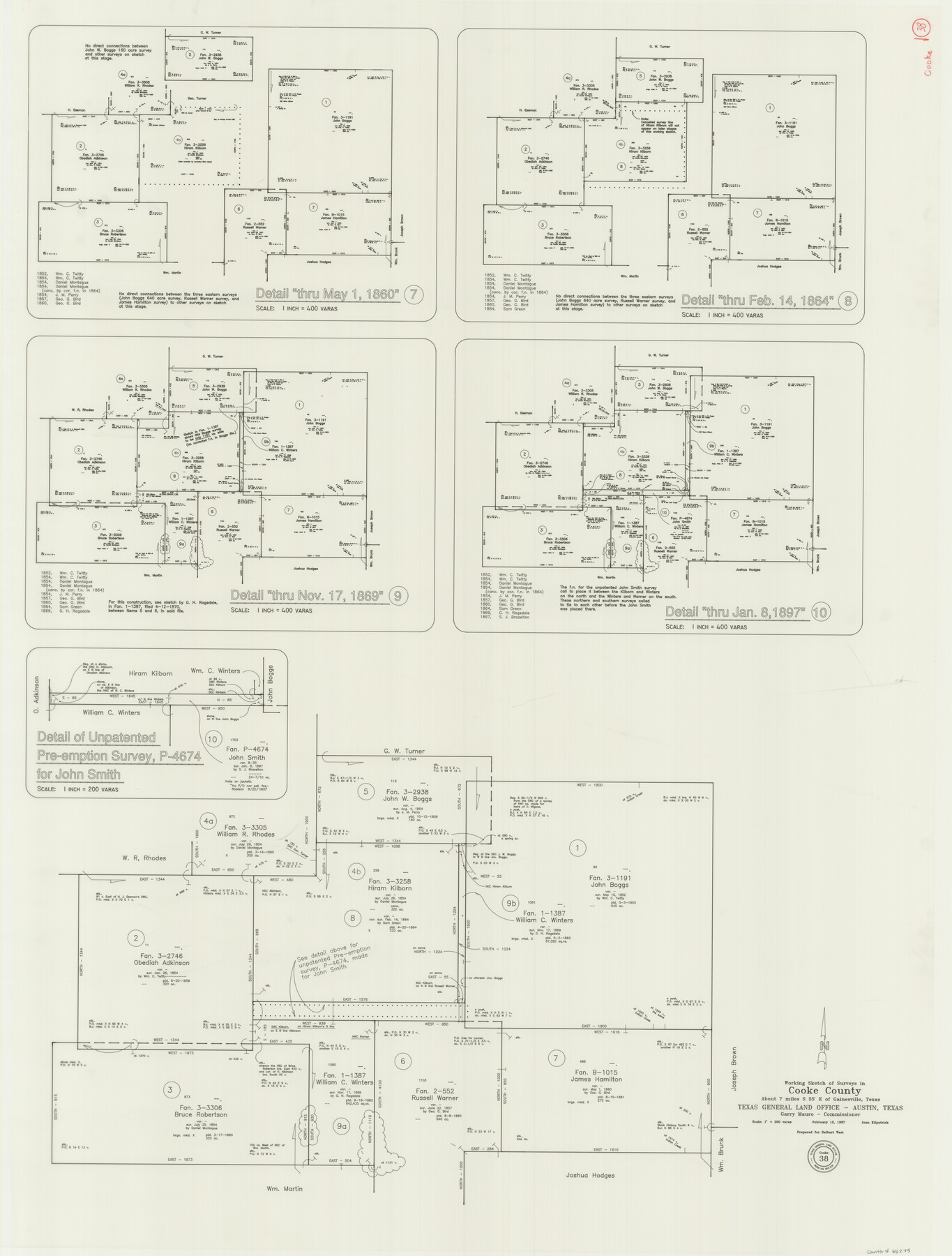
Cooke County Working Sketch 38
-
Map/Doc
68275
-
Collection
General Map Collection
-
Object Dates
2/12/1997 (Creation Date)
-
People and Organizations
Joan Kilpatrick (Draftsman)
-
Counties
Cooke
-
Subjects
Surveying Working Sketch
-
Height x Width
48.2 x 36.6 inches
122.4 x 93.0 cm
-
Scale
1" = 200 varas
Part of: General Map Collection
Flight Mission No. BRA-16M, Frame 125, Jefferson County

Print $20.00
- Digital $50.00
Flight Mission No. BRA-16M, Frame 125, Jefferson County
1953
Size 18.5 x 22.6 inches
Map/Doc 85735
Cameron County Rolled Sketch 20E

Print $20.00
- Digital $50.00
Cameron County Rolled Sketch 20E
Size 13.0 x 12.5 inches
Map/Doc 5478
Presidio County

Print $40.00
- Digital $50.00
Presidio County
1875
Size 98.1 x 58.7 inches
Map/Doc 16792
Throckmorton County Working Sketch 4

Print $20.00
- Digital $50.00
Throckmorton County Working Sketch 4
1949
Size 25.0 x 24.9 inches
Map/Doc 62113
Dawson County Sketch File 17

Print $18.00
- Digital $50.00
Dawson County Sketch File 17
Size 14.4 x 8.8 inches
Map/Doc 20558
Lubbock County Boundary File 2

Print $6.00
- Digital $50.00
Lubbock County Boundary File 2
Size 11.2 x 8.8 inches
Map/Doc 56488
Texas City Channel, Texas, Channel and Turning Basin Dredging - Sheet 1

Print $20.00
- Digital $50.00
Texas City Channel, Texas, Channel and Turning Basin Dredging - Sheet 1
1958
Size 29.3 x 40.8 inches
Map/Doc 61831
Harbor Pass and Bar at Brazos Santiago, Texas

Print $20.00
- Digital $50.00
Harbor Pass and Bar at Brazos Santiago, Texas
1871
Size 18.3 x 27.4 inches
Map/Doc 73036
Runnels County Working Sketch 28

Print $20.00
- Digital $50.00
Runnels County Working Sketch 28
1959
Size 41.9 x 35.2 inches
Map/Doc 63624
Jeff Davis County Sketch File 41

Print $40.00
- Digital $50.00
Jeff Davis County Sketch File 41
1959
Size 13.3 x 13.4 inches
Map/Doc 28064
Duval County Rolled Sketch 27

Print $40.00
- Digital $50.00
Duval County Rolled Sketch 27
Size 14.6 x 50.6 inches
Map/Doc 8814
Harris County Working Sketch 67

Print $20.00
- Digital $50.00
Harris County Working Sketch 67
1955
Size 23.3 x 27.5 inches
Map/Doc 65959
You may also like
General Highway Map, Atascosa County, Texas

Print $20.00
General Highway Map, Atascosa County, Texas
1961
Size 18.3 x 24.9 inches
Map/Doc 79356

Working Sketch in Wheeler County

Print $20.00
- Digital $50.00
Working Sketch in Wheeler County
1910
Size 7.0 x 39.5 inches
Map/Doc 90731
Flight Mission No. DQN-3K, Frame 64, Calhoun County

Print $20.00
- Digital $50.00
Flight Mission No. DQN-3K, Frame 64, Calhoun County
1953
Size 16.2 x 16.1 inches
Map/Doc 84355
Flight Mission No. BRA-16M, Frame 116, Jefferson County

Print $20.00
- Digital $50.00
Flight Mission No. BRA-16M, Frame 116, Jefferson County
1953
Size 18.5 x 22.3 inches
Map/Doc 85726
Val Verde County Working Sketch 2

Print $20.00
- Digital $50.00
Val Verde County Working Sketch 2
Size 27.9 x 23.8 inches
Map/Doc 72137
Flight Mission No. DAG-14K, Frame 146, Matagorda County

Print $20.00
- Digital $50.00
Flight Mission No. DAG-14K, Frame 146, Matagorda County
1952
Size 18.4 x 22.2 inches
Map/Doc 86313
Cameron County Working Sketch Graphic Index

Print $20.00
- Digital $50.00
Cameron County Working Sketch Graphic Index
1976
Size 32.0 x 39.4 inches
Map/Doc 76486
Township 6 North Range 13 West, North Western District, Louisiana

Print $20.00
- Digital $50.00
Township 6 North Range 13 West, North Western District, Louisiana
1841
Size 19.7 x 24.8 inches
Map/Doc 65864
Hansford County

Print $20.00
- Digital $50.00
Hansford County
1932
Size 38.7 x 38.0 inches
Map/Doc 73169
Schleicher County Sketch File 42

Print $40.00
- Digital $50.00
Schleicher County Sketch File 42
1963
Size 16.3 x 14.4 inches
Map/Doc 36546
Bird's Eye View of the City of San Antonio, Bexar County, Texas

Print $20.00
Bird's Eye View of the City of San Antonio, Bexar County, Texas
1873
Size 23.9 x 29.6 inches
Map/Doc 89203