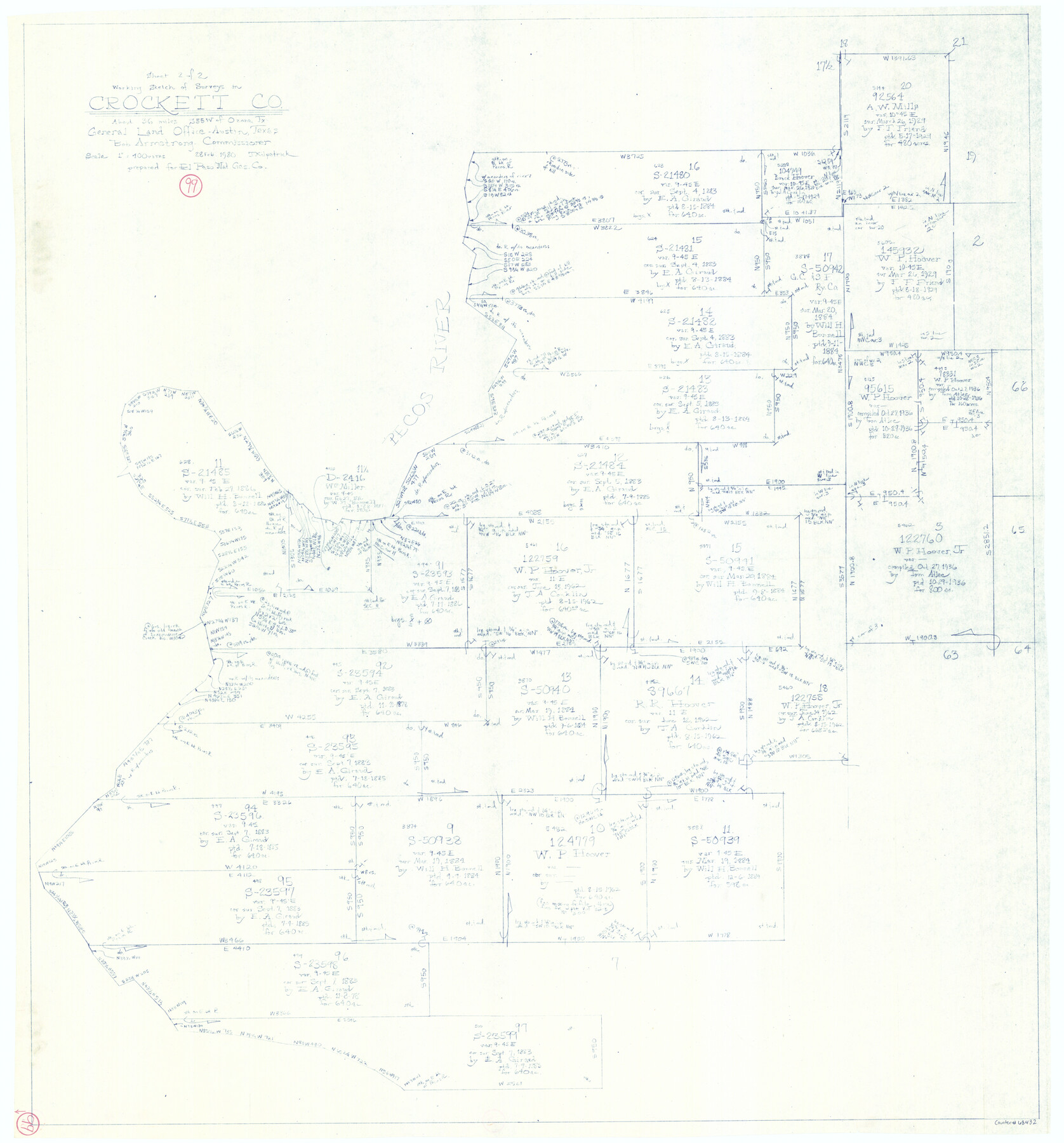
Crockett County Working Sketch 99
-
Map/Doc
68432
-
Collection
General Map Collection
-
Object Dates
2/28/1980 (Creation Date)
-
People and Organizations
Joan Kilpatrick (Draftsman)
-
Counties
Crockett
-
Subjects
Surveying Working Sketch
-
Height x Width
37.1 x 34.5 inches
94.2 x 87.6 cm
-
Scale
1" = 400 varas
Part of: General Map Collection
Corpus Christi Bay

Print $20.00
- Digital $50.00
Corpus Christi Bay
1961
Size 36.0 x 47.4 inches
Map/Doc 73471
Houston County Sketch File 22

Print $8.00
- Digital $50.00
Houston County Sketch File 22
1852
Size 12.6 x 8.2 inches
Map/Doc 26789
Jones County Working Sketch Graphic Index

Print $20.00
- Digital $50.00
Jones County Working Sketch Graphic Index
1921
Size 39.5 x 38.6 inches
Map/Doc 76599
Flight Mission No. DQN-1K, Frame 70, Calhoun County

Print $20.00
- Digital $50.00
Flight Mission No. DQN-1K, Frame 70, Calhoun County
1953
Size 18.6 x 22.3 inches
Map/Doc 84157
Flight Mission No. BRA-16M, Frame 88, Jefferson County

Print $20.00
- Digital $50.00
Flight Mission No. BRA-16M, Frame 88, Jefferson County
1953
Size 18.5 x 22.3 inches
Map/Doc 85700
Atascosa County Sketch File 9

Print $4.00
- Digital $50.00
Atascosa County Sketch File 9
1858
Size 8.1 x 12.6 inches
Map/Doc 13763
Roberts County Working Sketch 45

Print $20.00
- Digital $50.00
Roberts County Working Sketch 45
1979
Size 23.7 x 20.0 inches
Map/Doc 63571
Parker County Working Sketch 27

Print $20.00
- Digital $50.00
Parker County Working Sketch 27
2009
Map/Doc 89001
Tyler County Boundary File 89

Print $28.00
- Digital $50.00
Tyler County Boundary File 89
Size 9.2 x 7.2 inches
Map/Doc 59495

Harrison County Sketch File 15

Print $20.00
- Digital $50.00
Harrison County Sketch File 15
Size 23.2 x 23.0 inches
Map/Doc 11690
Pecos County Working Sketch Graphic Index - northeast part - sheet A

Print $20.00
- Digital $50.00
Pecos County Working Sketch Graphic Index - northeast part - sheet A
1975
Size 35.8 x 42.6 inches
Map/Doc 76666
You may also like
Tom Green County Boundary File 1

Print $48.00
- Digital $50.00
Tom Green County Boundary File 1
Size 8.8 x 3.8 inches
Map/Doc 59329
Pecos County Rolled Sketch 16

Print $40.00
- Digital $50.00
Pecos County Rolled Sketch 16
1882
Size 42.0 x 65.9 inches
Map/Doc 9682
Flight Mission No. DCL-6C, Frame 122, Kenedy County

Print $20.00
- Digital $50.00
Flight Mission No. DCL-6C, Frame 122, Kenedy County
1943
Size 18.5 x 22.4 inches
Map/Doc 85952
Flight Mission No. BRA-3M, Frame 122, Jefferson County

Print $20.00
- Digital $50.00
Flight Mission No. BRA-3M, Frame 122, Jefferson County
1953
Size 18.7 x 22.3 inches
Map/Doc 85396
Polk County Sketch File 28

Print $4.00
- Digital $50.00
Polk County Sketch File 28
Size 8.6 x 9.9 inches
Map/Doc 34198
Dawson County Boundary File 3 (2)

Print $40.00
- Digital $50.00
Dawson County Boundary File 3 (2)
Size 13.2 x 33.5 inches
Map/Doc 52367
[Atchison, Topeka & Santa Fe from Paisano to south of Plata]
![64713, [Atchison, Topeka & Santa Fe from Paisano to south of Plata], General Map Collection](https://historictexasmaps.com/wmedia_w700/maps/64713-1.tif.jpg)
Print $40.00
- Digital $50.00
[Atchison, Topeka & Santa Fe from Paisano to south of Plata]
Size 32.2 x 116.3 inches
Map/Doc 64713
Crockett County Sketch File 73

Print $6.00
- Digital $50.00
Crockett County Sketch File 73
1933
Size 11.2 x 8.7 inches
Map/Doc 19869
![94185, Texas [Recto], General Map Collection](https://historictexasmaps.com/wmedia_w700/maps/94185.tif.jpg)
Flight Mission No. CRK-8P, Frame 107, Refugio County

Print $20.00
- Digital $50.00
Flight Mission No. CRK-8P, Frame 107, Refugio County
1956
Size 18.4 x 22.0 inches
Map/Doc 86968
North Tech Addition, Section 18, Block A

Print $20.00
- Digital $50.00
North Tech Addition, Section 18, Block A
1952
Size 17.9 x 23.0 inches
Map/Doc 92756
Subdivision of Outlots 1 and 2 in Original Townsite of Seagraves, Texas

Print $20.00
- Digital $50.00
Subdivision of Outlots 1 and 2 in Original Townsite of Seagraves, Texas
1955
Size 17.3 x 29.1 inches
Map/Doc 92688