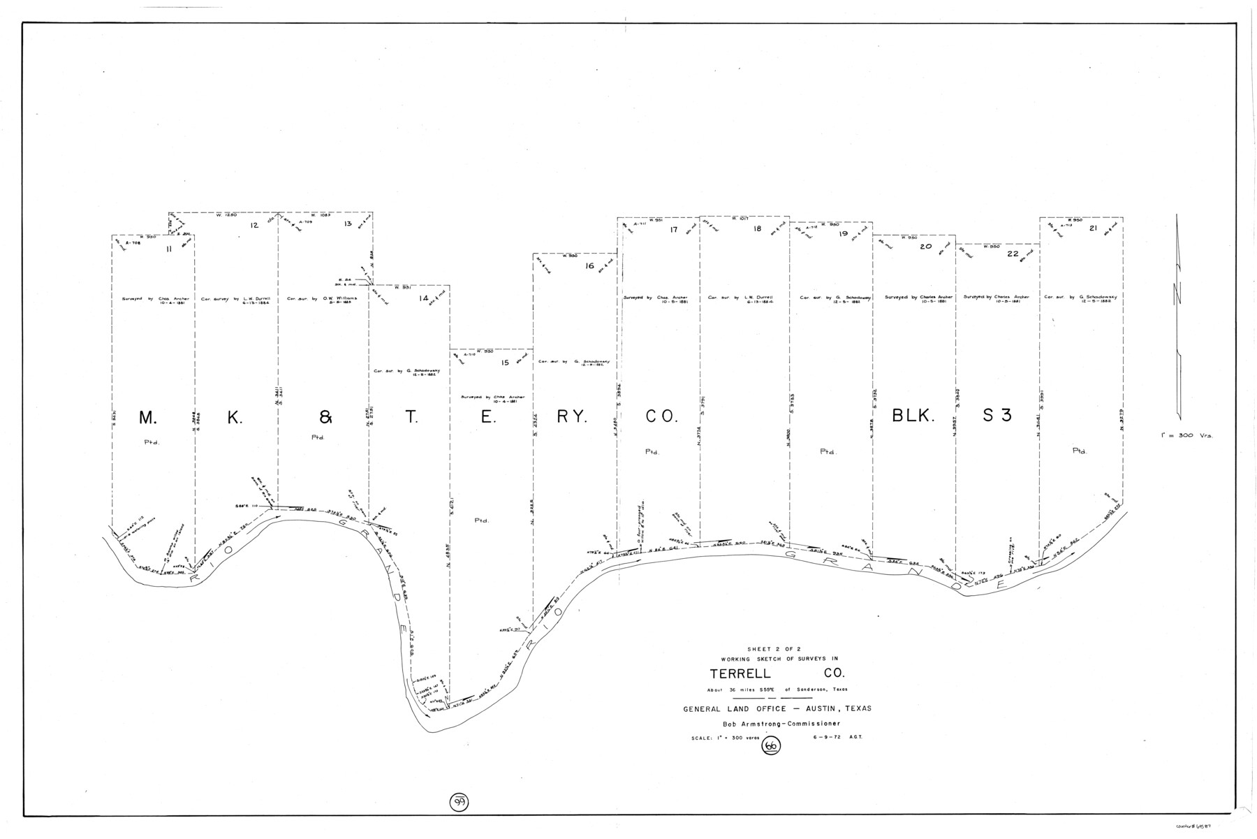
Terrell County Working Sketch 66
-
Map/Doc
69587
-
Collection
General Map Collection
-
Object Dates
6/9/1972 (Creation Date)
-
People and Organizations
Abner G. Trigg (Draftsman)
-
Counties
Terrell
-
Subjects
Surveying Working Sketch
-
Height x Width
32.1 x 48.1 inches
81.5 x 122.2 cm
-
Scale
1" = 300 varas
Part of: General Map Collection
[Plat of Trinity River w/ Midstream Profile in Liberty County by US Government 1899]
![65338, [Plat of Trinity River w/ Midstream Profile in Liberty County by US Government 1899], General Map Collection](https://historictexasmaps.com/wmedia_w700/maps/65338.tif.jpg)
Print $20.00
- Digital $50.00
[Plat of Trinity River w/ Midstream Profile in Liberty County by US Government 1899]
1899
Size 12.5 x 16.8 inches
Map/Doc 65338
Flight Mission No. BRA-3M, Frame 127, Jefferson County

Print $20.00
- Digital $50.00
Flight Mission No. BRA-3M, Frame 127, Jefferson County
1953
Size 18.5 x 21.6 inches
Map/Doc 85401
Louisiana and Texas Intracoastal Waterway - Matagorda Bay to San Antonio Bay Dredging - Sheet 1

Print $20.00
- Digital $50.00
Louisiana and Texas Intracoastal Waterway - Matagorda Bay to San Antonio Bay Dredging - Sheet 1
1938
Size 31.1 x 41.3 inches
Map/Doc 61814
Winkler County Rolled Sketch 13

Print $40.00
- Digital $50.00
Winkler County Rolled Sketch 13
1902
Size 39.5 x 48.7 inches
Map/Doc 10153
Pecos County Working Sketch 92

Print $40.00
- Digital $50.00
Pecos County Working Sketch 92
1966
Size 31.4 x 62.2 inches
Map/Doc 71565
McLennan County Sketch File 21

Print $4.00
- Digital $50.00
McLennan County Sketch File 21
Size 9.0 x 8.2 inches
Map/Doc 31294
Dickens County

Print $20.00
- Digital $50.00
Dickens County
1880
Size 20.8 x 19.1 inches
Map/Doc 3485
Duval County Boundary File 3g

Print $4.00
- Digital $50.00
Duval County Boundary File 3g
Size 9.9 x 7.8 inches
Map/Doc 52747
Fractional Township No. 6 South Range No. 4 West of the Indian Meridian, Indian Territory

Print $20.00
- Digital $50.00
Fractional Township No. 6 South Range No. 4 West of the Indian Meridian, Indian Territory
1898
Size 19.2 x 24.4 inches
Map/Doc 75191
Karnes County Boundary File 2a

Print $4.00
- Digital $50.00
Karnes County Boundary File 2a
Size 12.7 x 8.1 inches
Map/Doc 55692
Flight Mission No. CRC-4R, Frame 96, Chambers County

Print $20.00
- Digital $50.00
Flight Mission No. CRC-4R, Frame 96, Chambers County
1956
Size 18.4 x 22.2 inches
Map/Doc 84893
Nacogdoches Co.

Print $20.00
- Digital $50.00
Nacogdoches Co.
1905
Size 47.6 x 40.5 inches
Map/Doc 66948
You may also like
[Gulf Coast of Texas]
![72703, [Gulf Coast of Texas], General Map Collection](https://historictexasmaps.com/wmedia_w700/maps/72703.tif.jpg)
Print $20.00
- Digital $50.00
[Gulf Coast of Texas]
1881
Size 28.9 x 18.2 inches
Map/Doc 72703
Padre Island National Seashore

Print $4.00
- Digital $50.00
Padre Island National Seashore
Size 16.0 x 21.8 inches
Map/Doc 60527
The Judicial District/County of Madison. Created, February 2, 1842

Print $20.00
The Judicial District/County of Madison. Created, February 2, 1842
2020
Size 18.2 x 21.7 inches
Map/Doc 96333
Reeves County Sketch File 25

Print $4.00
- Digital $50.00
Reeves County Sketch File 25
1873
Size 8.4 x 5.6 inches
Map/Doc 35224

Borden County Rolled Sketch 6

Print $20.00
- Digital $50.00
Borden County Rolled Sketch 6
Size 24.6 x 18.6 inches
Map/Doc 5156
Flight Mission No. BQR-22K, Frame 45, Brazoria County

Print $20.00
- Digital $50.00
Flight Mission No. BQR-22K, Frame 45, Brazoria County
1953
Size 18.7 x 22.4 inches
Map/Doc 84129
Andrews County Sketch File 1

Print $6.00
- Digital $50.00
Andrews County Sketch File 1
Size 9.0 x 13.6 inches
Map/Doc 12818
Pecos County Sketch File 91

Print $20.00
- Digital $50.00
Pecos County Sketch File 91
1951
Size 20.9 x 14.0 inches
Map/Doc 12184
Kleberg County Working Sketch Graphic Index

Print $20.00
- Digital $50.00
Kleberg County Working Sketch Graphic Index
1913
Size 29.0 x 32.9 inches
Map/Doc 76610
Archer County Working Sketch 17

Print $3.00
- Digital $50.00
Archer County Working Sketch 17
1951
Size 10.7 x 12.2 inches
Map/Doc 67158
Atascosa County Rolled Sketch 24

Print $20.00
- Digital $50.00
Atascosa County Rolled Sketch 24
Size 38.3 x 45.2 inches
Map/Doc 5101