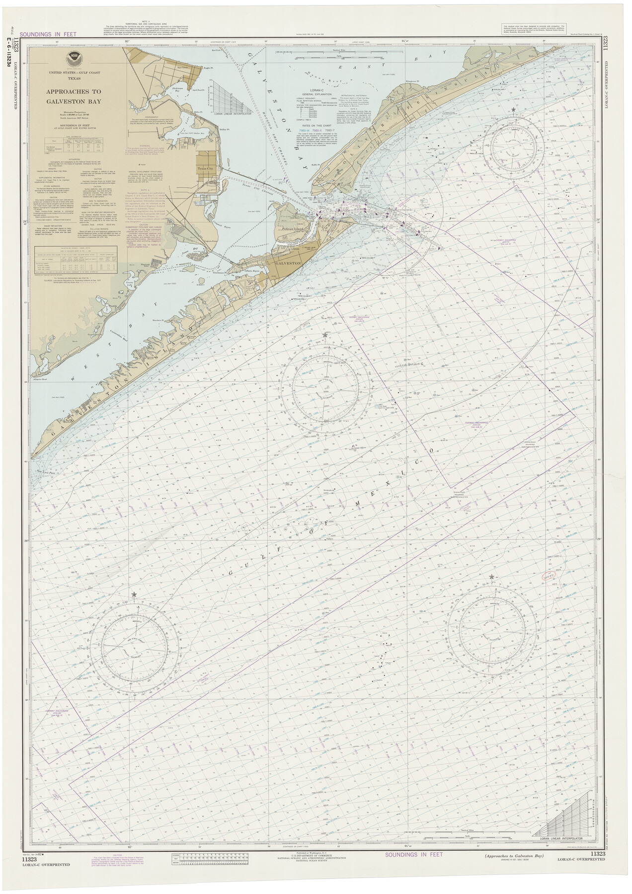
Galveston Bay and Approaches
K-6-1282d
-
Map/Doc
69885
-
Collection
General Map Collection
-
Object Dates
4/24/1982 (Creation Date)
-
Counties
Galveston
-
Subjects
Nautical Charts
-
Height x Width
51.4 x 37.0 inches
130.6 x 94.0 cm
Part of: General Map Collection
Harrison County Working Sketch 22

Print $40.00
- Digital $50.00
Harrison County Working Sketch 22
1982
Size 54.2 x 37.0 inches
Map/Doc 66042
Flight Mission No. CRC-5R, Frame 35, Chambers County

Print $20.00
- Digital $50.00
Flight Mission No. CRC-5R, Frame 35, Chambers County
1956
Size 18.5 x 22.3 inches
Map/Doc 84954
Flight Mission No. DCL-6C, Frame 5, Kenedy County

Print $20.00
- Digital $50.00
Flight Mission No. DCL-6C, Frame 5, Kenedy County
1943
Size 18.4 x 22.4 inches
Map/Doc 85865

Map of Martin County

Print $20.00
- Digital $50.00
Map of Martin County
1900
Size 41.9 x 35.0 inches
Map/Doc 4789
Wharton County

Print $40.00
- Digital $50.00
Wharton County
1894
Size 55.8 x 36.0 inches
Map/Doc 87352
Crane County Working Sketch 25

Print $20.00
- Digital $50.00
Crane County Working Sketch 25
1969
Size 33.0 x 26.3 inches
Map/Doc 68302
Tom Green Co.

Print $40.00
- Digital $50.00
Tom Green Co.
1887
Size 42.0 x 110.7 inches
Map/Doc 76034
Presidio County

Print $40.00
- Digital $50.00
Presidio County
1875
Size 98.1 x 58.7 inches
Map/Doc 16792
Flight Mission No. DAG-22K, Frame 76, Matagorda County

Print $20.00
- Digital $50.00
Flight Mission No. DAG-22K, Frame 76, Matagorda County
1953
Size 18.7 x 22.4 inches
Map/Doc 86463
Nueces County Rolled Sketch 50

Print $20.00
- Digital $50.00
Nueces County Rolled Sketch 50
1939
Size 21.9 x 38.0 inches
Map/Doc 9605
Archer County Boundary File 2

Print $92.00
- Digital $50.00
Archer County Boundary File 2
Size 14.4 x 8.4 inches
Map/Doc 50086
You may also like
Flight Mission No. DCL-7C, Frame 67, Kenedy County

Print $20.00
- Digital $50.00
Flight Mission No. DCL-7C, Frame 67, Kenedy County
1943
Size 15.5 x 15.3 inches
Map/Doc 86053
Rand McNally Main Highway Map of Texas

Print $20.00
Rand McNally Main Highway Map of Texas
1923
Size 27.7 x 40.3 inches
Map/Doc 76260
General Highway Map, Wheeler County, Texas

Print $20.00
General Highway Map, Wheeler County, Texas
1961
Size 18.1 x 24.9 inches
Map/Doc 79708
Parker County Working Sketch 22

Print $20.00
- Digital $50.00
Parker County Working Sketch 22
2007
Map/Doc 88607
Webb County Sketch File F

Print $6.00
- Digital $50.00
Webb County Sketch File F
1900
Size 10.7 x 15.1 inches
Map/Doc 39699
Pecos County Working Sketch 17

Print $20.00
- Digital $50.00
Pecos County Working Sketch 17
1915
Size 32.5 x 23.0 inches
Map/Doc 71487
Childress County Sketch File 23

Print $4.00
- Digital $50.00
Childress County Sketch File 23
1892
Size 10.9 x 8.7 inches
Map/Doc 18382
Reagan County Sketch File 19

Print $26.00
- Digital $50.00
Reagan County Sketch File 19
1937
Size 14.0 x 28.7 inches
Map/Doc 12220
Harris County Working Sketch 103

Print $20.00
- Digital $50.00
Harris County Working Sketch 103
1980
Size 18.6 x 16.8 inches
Map/Doc 65995

Terrell County Working Sketch 69

Print $20.00
- Digital $50.00
Terrell County Working Sketch 69
1978
Size 28.0 x 32.7 inches
Map/Doc 69590
[Cemetary, Unknown Location]
![75552, [Cemetary, Unknown Location], Maddox Collection](https://historictexasmaps.com/wmedia_w700/maps/75552.tif.jpg)
Print $20.00
- Digital $50.00
[Cemetary, Unknown Location]
Size 30.6 x 14.9 inches
Map/Doc 75552