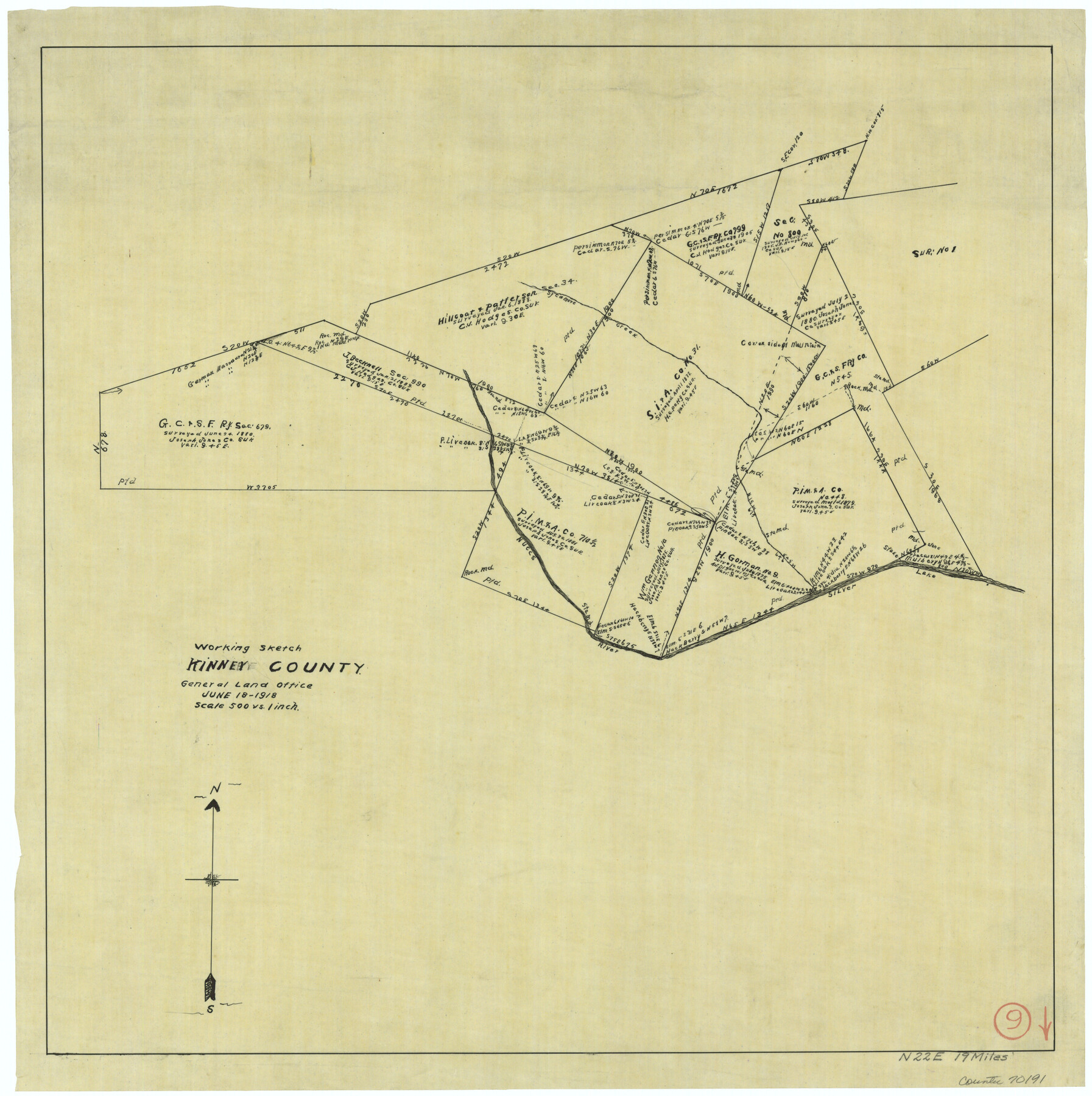
Kinney County Working Sketch 9
- 
                          Map/Doc70191
- 
                            CollectionGeneral Map Collection
- 
                            Object Dates6/18/1918 (Creation Date)
- 
                            CountiesKinney
- 
                            SubjectsSurveying Working Sketch
- 
                            Height x Width20.4 x 20.4 inches51.8 x 51.8 cm
- 
                            Scale1" = 500 varas
Part of: General Map Collection
            Maverick County Sketch File 7


                                            Print $15.00                    
                                             -                         Digital $50.00                                    
                Maverick County Sketch File 7
1878
Size 16.6 x 3.9 inches
                                Map/Doc 31057
            
            Gray County Working Sketch 8


                                            Print $20.00                    
                                             -                         Digital $50.00                                    
                Gray County Working Sketch 8
1983
Size 18.3 x 22.8 inches
                                Map/Doc 63239
            
            Coke County Rolled Sketch 10


                                            Print $20.00                    
                                             -                         Digital $50.00                                    
                Coke County Rolled Sketch 10
1949
Size 25.3 x 15.0 inches
                                Map/Doc 5509
            
            Anderson County Sketch File 29


                                            Print $4.00                    
                                             -                         Digital $50.00                                    
                Anderson County Sketch File 29
1873
Size 10.4 x 8.2 inches
                                Map/Doc 12814
            
            Childress County


                                            Print $20.00                    
                                             -                         Digital $50.00                                    
                Childress County
1884
Size 20.6 x 17.4 inches
                                Map/Doc 3395
            
            Kimble County Rolled Sketch 35


                                            Print $20.00                    
                                             -                         Digital $50.00                                    
                Kimble County Rolled Sketch 35
1978
Size 20.0 x 19.6 inches
                                Map/Doc 6525
            
            Montague County Working Sketch 32


                                            Print $20.00                    
                                             -                         Digital $50.00                                    
                Montague County Working Sketch 32
1975
Size 26.0 x 26.1 inches
                                Map/Doc 71098
            
            [FT. W. & R. G. Ry. Right of Way Map, Winchell to Brady, McCulloch County, Texas]
            
                                    ![61415, [FT. W. & R. G. Ry. Right of Way Map, Winchell to Brady, McCulloch County, Texas], General Map Collection](https://historictexasmaps.com/wmedia_w700/maps/61415.tif.jpg) 


    ![61415, [FT. W. & R. G. Ry. Right of Way Map, Winchell to Brady, McCulloch County, Texas], General Map Collection](https://historictexasmaps.com/wmedia_w700/maps/61415.tif.jpg) 
                                
            
                                            Print $40.00                    
                                             -                         Digital $50.00                                    
                [FT. W. & R. G. Ry. Right of Way Map, Winchell to Brady, McCulloch County, Texas]
1918
Size 38.2 x 122.0 inches
                                Map/Doc 61415
            
            Terrell County Rolled Sketch 46


                                            Print $20.00                    
                                             -                         Digital $50.00                                    
                Terrell County Rolled Sketch 46
1958
Size 16.1 x 14.6 inches
                                Map/Doc 7948
            
            Bowie County Working Sketch 11


                                            Print $20.00                    
                                             -                         Digital $50.00                                    
                Bowie County Working Sketch 11
1958
Size 43.2 x 31.6 inches
                                Map/Doc 67415
            
            Flight Mission No. CRC-3R, Frame 19, Chambers County


                                            Print $20.00                    
                                             -                         Digital $50.00                                    
                Flight Mission No. CRC-3R, Frame 19, Chambers County
1956
Size 18.5 x 22.1 inches
                                Map/Doc 84793
            
            Aransas County Rolled Sketch 27


                                            Print $20.00                    
                                             -                         Digital $50.00                                    
                Aransas County Rolled Sketch 27
1983
Size 24.9 x 35.4 inches
                                Map/Doc 5059
            You may also like
            Houston County Working Sketch 27


                                            Print $20.00                    
                                             -                         Digital $50.00                                    
                Houston County Working Sketch 27
1988
Size 34.9 x 28.5 inches
                                Map/Doc 66257
            
            Floyd County Sketch File 12


                                            Print $10.00                    
                                             -                         Digital $50.00                                    
                Floyd County Sketch File 12
1913
Size 10.8 x 8.8 inches
                                Map/Doc 22708
            
            Dallam County


                                            Print $40.00                    
                                             -                         Digital $50.00                                    
                Dallam County
1926
Size 40.1 x 48.6 inches
                                Map/Doc 73125
            
            Map of the Northeast Part of the Pitchfork Ranch


                                            Print $20.00                    
                                             -                         Digital $50.00                                    
                Map of the Northeast Part of the Pitchfork Ranch
1916
Size 23.4 x 23.4 inches
                                Map/Doc 90980
            
            Gaines County


                                            Print $40.00                    
                                             -                         Digital $50.00                                    
                Gaines County
1902
Size 38.9 x 49.7 inches
                                Map/Doc 66832
            
            Val Verde County Sketch File 37


                                            Print $24.00                    
                                             -                         Digital $50.00                                    
                Val Verde County Sketch File 37
1938
Size 15.5 x 22.3 inches
                                Map/Doc 12578
            
            Parker County Rolled Sketch 1


                                            Print $20.00                    
                                             -                         Digital $50.00                                    
                Parker County Rolled Sketch 1
1878
Size 19.8 x 24.6 inches
                                Map/Doc 7202
            
            Starr County Sketch File 14


                                            Print $40.00                    
                                             -                         Digital $50.00                                    
                Starr County Sketch File 14
Size 23.8 x 46.0 inches
                                Map/Doc 4626
            
            [Surveys in Austin's Colony along the east bank of the Navidad River]
            
                                    ![211, [Surveys in Austin's Colony along the east bank of the Navidad River], General Map Collection](https://historictexasmaps.com/wmedia_w700/maps/211.tif.jpg) 


    ![211, [Surveys in Austin's Colony along the east bank of the Navidad River], General Map Collection](https://historictexasmaps.com/wmedia_w700/maps/211.tif.jpg) 
                                
            
                                            Print $20.00                    
                                             -                         Digital $50.00                                    
                [Surveys in Austin's Colony along the east bank of the Navidad River]
1827
Size 20.2 x 16.1 inches
                                Map/Doc 211
            
            [Public School Land Blocks B1 and B7]
            
                                    ![91974, [Public School Land Blocks B1 and B7], Twichell Survey Records](https://historictexasmaps.com/wmedia_w700/maps/91974-1.tif.jpg) 


    ![91974, [Public School Land Blocks B1 and B7], Twichell Survey Records](https://historictexasmaps.com/wmedia_w700/maps/91974-1.tif.jpg) 
                                
            
                                            Print $20.00                    
                                             -                         Digital $50.00                                    
                [Public School Land Blocks B1 and B7]
Size 22.9 x 14.8 inches
                                Map/Doc 91974
            
            Flight Mission No. DIX-10P, Frame 178, Aransas County


                                            Print $20.00                    
                                             -                         Digital $50.00                                    
                Flight Mission No. DIX-10P, Frame 178, Aransas County
1956
Size 18.5 x 22.2 inches
                                Map/Doc 83968
            
            Pecos County Rolled Sketch Q


                                            Print $20.00                    
                                             -                         Digital $50.00                                    
                Pecos County Rolled Sketch Q
Size 18.7 x 12.2 inches
                                Map/Doc 7311
            