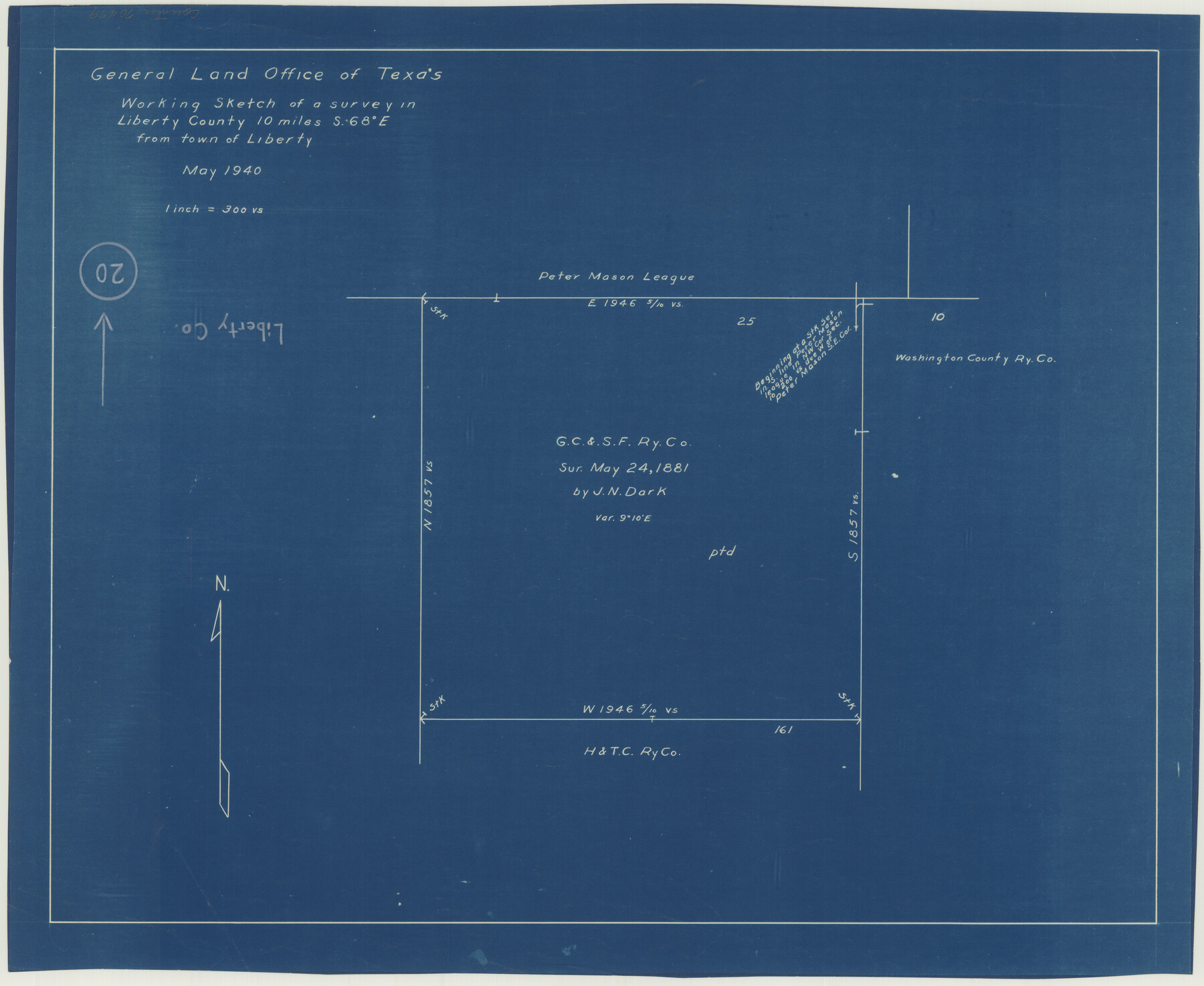
Liberty County Working Sketch 20
-
Map/Doc
70479
-
Collection
General Map Collection
-
Object Dates
5/1940 (Creation Date)
-
Counties
Liberty
-
Subjects
Surveying Working Sketch
-
Height x Width
14.5 x 17.7 inches
36.8 x 45.0 cm
-
Scale
1" = 300 varas
Part of: General Map Collection
Kendall County Rolled Sketch 8

Print $20.00
- Digital $50.00
Kendall County Rolled Sketch 8
1994
Size 17.0 x 18.3 inches
Map/Doc 6461
Map of the Passo Cavallo on the entrance into Matagorda Bay from the Gulf of Mexico

Print $20.00
- Digital $50.00
Map of the Passo Cavallo on the entrance into Matagorda Bay from the Gulf of Mexico
1839
Size 18.4 x 26.9 inches
Map/Doc 72764
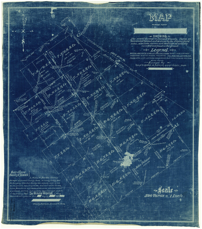
Dimmit County Rolled Sketch 6
Print $20.00
- Digital $50.00
Dimmit County Rolled Sketch 6
Size 31.1 x 27.4 inches
Map/Doc 5716
Childress County Sketch File 12

Print $22.00
- Digital $50.00
Childress County Sketch File 12
Size 13.3 x 8.7 inches
Map/Doc 18255
Hunt County Boundary File 11a

Print $15.00
- Digital $50.00
Hunt County Boundary File 11a
Size 11.1 x 8.9 inches
Map/Doc 55272
Presidio County Working Sketch 9a

Print $20.00
- Digital $50.00
Presidio County Working Sketch 9a
1933
Size 17.3 x 12.2 inches
Map/Doc 71684
Pecos County Working Sketch 110

Print $40.00
- Digital $50.00
Pecos County Working Sketch 110
1972
Size 32.3 x 50.6 inches
Map/Doc 71583
Garza County Rolled Sketch 15

Print $20.00
- Digital $50.00
Garza County Rolled Sketch 15
1904
Size 18.6 x 20.2 inches
Map/Doc 6002
Flight Mission No. CRC-6R, Frame 13, Chambers County

Print $20.00
- Digital $50.00
Flight Mission No. CRC-6R, Frame 13, Chambers County
1956
Size 18.6 x 22.3 inches
Map/Doc 84967
Colorado County Working Sketch 26

Print $20.00
- Digital $50.00
Colorado County Working Sketch 26
1977
Size 22.7 x 18.7 inches
Map/Doc 68126
Bastrop County Working Sketch 13

Print $20.00
- Digital $50.00
Bastrop County Working Sketch 13
1979
Size 23.6 x 30.0 inches
Map/Doc 67313
Hardin County Working Sketch 12

Print $20.00
- Digital $50.00
Hardin County Working Sketch 12
1934
Size 16.8 x 11.9 inches
Map/Doc 63410
You may also like
Montgomery County Rolled Sketch 9

Print $20.00
- Digital $50.00
Montgomery County Rolled Sketch 9
1899
Size 19.5 x 20.1 inches
Map/Doc 6795
Navigation Maps of Gulf Intracoastal Waterway, Port Arthur to Brownsville, Texas

Print $4.00
- Digital $50.00
Navigation Maps of Gulf Intracoastal Waterway, Port Arthur to Brownsville, Texas
1951
Size 16.6 x 21.5 inches
Map/Doc 65430
Brown County Rolled Sketch 2A

Print $20.00
- Digital $50.00
Brown County Rolled Sketch 2A
1984
Size 25.6 x 37.4 inches
Map/Doc 5350
Motley County Sketch File 1 (N)

Print $4.00
- Digital $50.00
Motley County Sketch File 1 (N)
Size 11.4 x 6.7 inches
Map/Doc 31994
Leon County Boundary File 1

Print $34.00
- Digital $50.00
Leon County Boundary File 1
Size 21.0 x 6.6 inches
Map/Doc 56281
El Paso County Rolled Sketch 50

Print $20.00
- Digital $50.00
El Paso County Rolled Sketch 50
1956
Size 18.9 x 26.7 inches
Map/Doc 5835
Gillespie County

Print $20.00
- Digital $50.00
Gillespie County
1918
Size 35.8 x 47.4 inches
Map/Doc 81950
Travis County State Real Property Sketch 15

Print $20.00
- Digital $50.00
Travis County State Real Property Sketch 15
1995
Size 29.6 x 29.5 inches
Map/Doc 61674
Stonewall County Rolled Sketch 10

Print $20.00
- Digital $50.00
Stonewall County Rolled Sketch 10
Size 22.3 x 29.6 inches
Map/Doc 7866
Bell County Sketch File 1

Print $40.00
- Digital $50.00
Bell County Sketch File 1
1847
Size 14.7 x 12.4 inches
Map/Doc 14365
Map of Kimble County

Print $40.00
- Digital $50.00
Map of Kimble County
1890
Size 36.1 x 54.4 inches
Map/Doc 78436
Cooke County Sketch File 2

Print $20.00
- Digital $50.00
Cooke County Sketch File 2
Size 9.6 x 21.6 inches
Map/Doc 11169