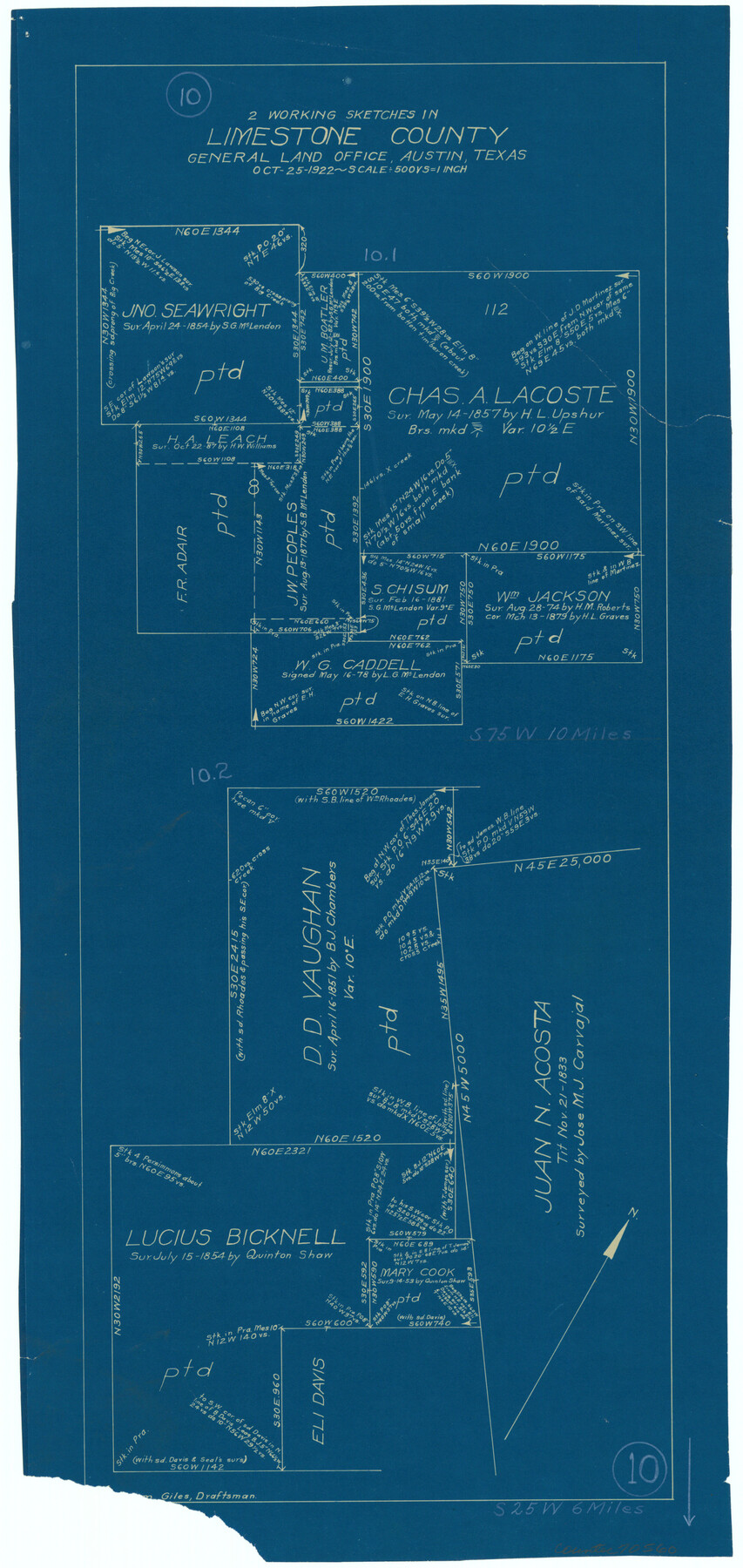
Limestone County Working Sketch 10
-
Map/Doc
70560
-
Collection
General Map Collection
-
Object Dates
10/25/1922 (Creation Date)
-
People and Organizations
J. Bascom Giles (Draftsman)
-
Counties
Limestone
-
Subjects
Surveying Working Sketch
-
Height x Width
21.1 x 10.0 inches
53.6 x 25.4 cm
-
Scale
1" = 500 varas
Part of: General Map Collection
Kerr County Working Sketch 7

Print $20.00
- Digital $50.00
Kerr County Working Sketch 7
1947
Size 38.9 x 30.8 inches
Map/Doc 70038

Roberts County Working Sketch 34

Print $20.00
- Digital $50.00
Roberts County Working Sketch 34
1978
Size 26.6 x 22.5 inches
Map/Doc 63560
Potter County Sketch File 16

Print $38.00
- Digital $50.00
Potter County Sketch File 16
Size 13.0 x 13.9 inches
Map/Doc 34401
Aransas County Sketch File 25

Print $20.00
- Digital $50.00
Aransas County Sketch File 25
Size 17.0 x 17.5 inches
Map/Doc 13218
Titus County Sketch File 1

Print $4.00
- Digital $50.00
Titus County Sketch File 1
Size 13.3 x 8.2 inches
Map/Doc 38130
Donley County Working Sketch 5

Print $40.00
- Digital $50.00
Donley County Working Sketch 5
Size 54.3 x 32.9 inches
Map/Doc 68738

Bastrop County

Print $20.00
- Digital $50.00
Bastrop County
1883
Size 25.9 x 25.2 inches
Map/Doc 3276
Bell County Sketch File 22

Print $4.00
- Digital $50.00
Bell County Sketch File 22
1872
Size 10.2 x 8.0 inches
Map/Doc 14412
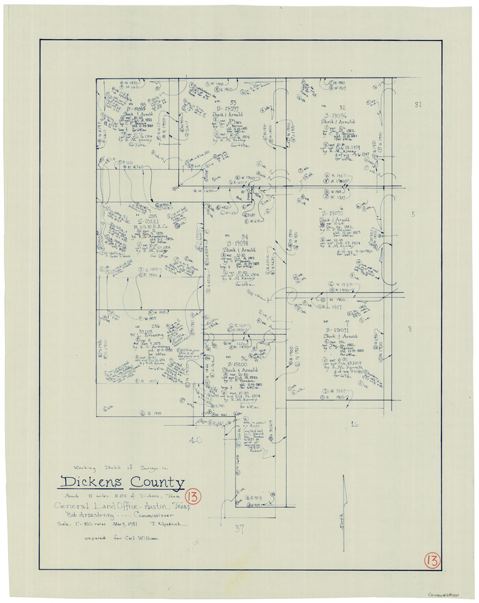
Dickens County Working Sketch 13
Print $20.00
- Digital $50.00
Dickens County Working Sketch 13
1981
Size 26.8 x 21.4 inches
Map/Doc 68661
Lamar County State Real Property Sketch 1

Print $20.00
- Digital $50.00
Lamar County State Real Property Sketch 1
2013
Size 24.0 x 36.0 inches
Map/Doc 93660
You may also like
Val Verde County Sketch File 44A

Print $10.00
- Digital $50.00
Val Verde County Sketch File 44A
1940
Size 14.5 x 8.8 inches
Map/Doc 39311
Terrell County Working Sketch 44

Print $40.00
- Digital $50.00
Terrell County Working Sketch 44
1957
Size 40.0 x 71.4 inches
Map/Doc 62137
[Sketch showing B. S. & F. Block 9 and vicinity]
![89786, [Sketch showing B. S. & F. Block 9 and vicinity], Twichell Survey Records](https://historictexasmaps.com/wmedia_w700/maps/89786-1.tif.jpg)
Print $20.00
- Digital $50.00
[Sketch showing B. S. & F. Block 9 and vicinity]
Size 39.0 x 47.6 inches
Map/Doc 89786
Hill County Boundary File 45

Print $41.00
- Digital $50.00
Hill County Boundary File 45
Size 9.0 x 3.6 inches
Map/Doc 54743
Hill County Sketch File 27

Print $4.00
- Digital $50.00
Hill County Sketch File 27
1873
Size 10.4 x 8.2 inches
Map/Doc 26528
Map of Madison County, Texas

Print $20.00
- Digital $50.00
Map of Madison County, Texas
1879
Size 17.1 x 21.7 inches
Map/Doc 643
Collingsworth County Rolled Sketch 3

Print $40.00
- Digital $50.00
Collingsworth County Rolled Sketch 3
1941
Size 55.7 x 23.2 inches
Map/Doc 8639
The Republic County of Bowie. January 16, 1843

Print $20.00
The Republic County of Bowie. January 16, 1843
2020
Size 19.5 x 21.7 inches
Map/Doc 96106
Flight Mission No. DCL-7C, Frame 9, Kenedy County

Print $20.00
- Digital $50.00
Flight Mission No. DCL-7C, Frame 9, Kenedy County
1943
Size 15.3 x 15.2 inches
Map/Doc 86001
Map of the Southwestern and part of the Western States to illustrate Olney's school geography

Print $20.00
- Digital $50.00
Map of the Southwestern and part of the Western States to illustrate Olney's school geography
1844
Size 19.0 x 12.1 inches
Map/Doc 93541
Motley County Sketch File 9 (N)

Print $10.00
- Digital $50.00
Motley County Sketch File 9 (N)
1902
Size 11.1 x 8.6 inches
Map/Doc 32019
Ellis County Sketch File 14

Print $40.00
- Digital $50.00
Ellis County Sketch File 14
1861
Size 12.9 x 16.1 inches
Map/Doc 21854