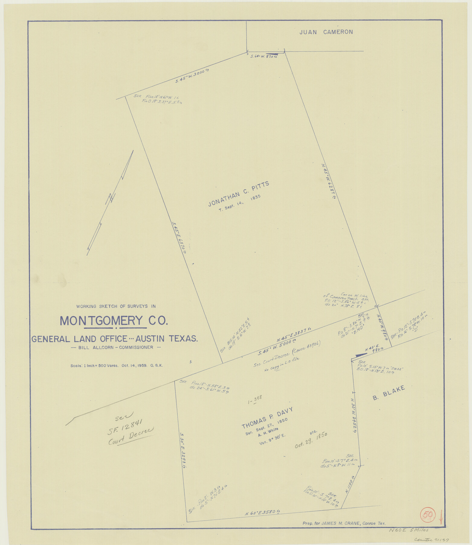
Montgomery County Working Sketch 50
-
Map/Doc
71157
-
Collection
General Map Collection
-
Object Dates
10/14/1959 (Creation Date)
-
People and Organizations
Otto G. Kurio (Draftsman)
-
Counties
Montgomery
-
Subjects
Surveying Working Sketch
-
Height x Width
25.3 x 21.9 inches
64.3 x 55.6 cm
-
Scale
1" = 500 varas
Part of: General Map Collection
Brewster County Rolled Sketch 73

Print $20.00
- Digital $50.00
Brewster County Rolled Sketch 73
1938
Size 19.7 x 23.3 inches
Map/Doc 5239
Hall County Sketch File C2

Print $6.00
- Digital $50.00
Hall County Sketch File C2
1905
Size 14.4 x 9.0 inches
Map/Doc 24789
Jackson County

Print $40.00
- Digital $50.00
Jackson County
1920
Size 49.5 x 41.8 inches
Map/Doc 66878
Upshur County Sketch File 11

Print $22.00
- Digital $50.00
Upshur County Sketch File 11
Size 8.4 x 10.4 inches
Map/Doc 38750
Flight Mission No. CLL-1N, Frame 36, Willacy County

Print $20.00
- Digital $50.00
Flight Mission No. CLL-1N, Frame 36, Willacy County
1954
Size 18.3 x 22.1 inches
Map/Doc 87017
Reeves County Working Sketch 6

Print $20.00
- Digital $50.00
Reeves County Working Sketch 6
1943
Size 14.1 x 18.4 inches
Map/Doc 63449
Cherokee County Working Sketch 17

Print $40.00
- Digital $50.00
Cherokee County Working Sketch 17
1958
Size 81.6 x 43.3 inches
Map/Doc 67972
Map of east part of West Bay & SW part of Galveston Bay, Galveston County showing subdivision for mineral development

Print $20.00
- Digital $50.00
Map of east part of West Bay & SW part of Galveston Bay, Galveston County showing subdivision for mineral development
1951
Size 32.6 x 37.6 inches
Map/Doc 2975
Kinney County Working Sketch 9

Print $20.00
- Digital $50.00
Kinney County Working Sketch 9
1918
Size 20.4 x 20.4 inches
Map/Doc 70191
Flight Mission No. CRC-2R, Frame 201, Chambers County

Print $20.00
- Digital $50.00
Flight Mission No. CRC-2R, Frame 201, Chambers County
1956
Size 18.5 x 22.3 inches
Map/Doc 84779
Crockett County Working Sketch 23

Print $20.00
- Digital $50.00
Crockett County Working Sketch 23
1919
Size 35.1 x 33.7 inches
Map/Doc 68356
Hunt County Sketch File 36a

Print $6.00
- Digital $50.00
Hunt County Sketch File 36a
Size 10.5 x 11.5 inches
Map/Doc 27153
You may also like
Travis County Working Sketch 30

Print $20.00
- Digital $50.00
Travis County Working Sketch 30
1963
Size 30.5 x 35.1 inches
Map/Doc 69414
Current Miscellaneous File 4

Print $8.00
- Digital $50.00
Current Miscellaneous File 4
1947
Size 11.5 x 9.1 inches
Map/Doc 73723
Harris County Sketch File 90

Print $46.00
- Digital $50.00
Harris County Sketch File 90
1967
Size 12.2 x 14.4 inches
Map/Doc 25596
Denton County Working Sketch 27

Print $20.00
- Digital $50.00
Denton County Working Sketch 27
1996
Size 41.3 x 35.3 inches
Map/Doc 68632
Brazos River Conservation and Reclamation District Official Boundary Line Survey, Parmer County

Print $20.00
- Digital $50.00
Brazos River Conservation and Reclamation District Official Boundary Line Survey, Parmer County
Size 24.6 x 16.8 inches
Map/Doc 91659
Flight Mission No. DQN-2K, Frame 190, Calhoun County

Print $20.00
- Digital $50.00
Flight Mission No. DQN-2K, Frame 190, Calhoun County
1953
Size 18.5 x 22.2 inches
Map/Doc 84331
Hill County Sketch File 27

Print $4.00
- Digital $50.00
Hill County Sketch File 27
1873
Size 10.4 x 8.2 inches
Map/Doc 26528

McCulloch County

Print $20.00
- Digital $50.00
McCulloch County
1949
Size 41.0 x 31.1 inches
Map/Doc 77361
Jones County Sketch File 10a

Print $40.00
- Digital $50.00
Jones County Sketch File 10a
1875
Size 40.0 x 50.6 inches
Map/Doc 10509
Map of Block X in the Name of Jesse F. Cross, Situated in Martin and Dawson Counties, Texas

Print $20.00
- Digital $50.00
Map of Block X in the Name of Jesse F. Cross, Situated in Martin and Dawson Counties, Texas
1908
Size 26.2 x 42.4 inches
Map/Doc 91356
Trinity River, Wildcat Ferry Sheet

Print $20.00
- Digital $50.00
Trinity River, Wildcat Ferry Sheet
1928
Size 41.5 x 40.9 inches
Map/Doc 65182