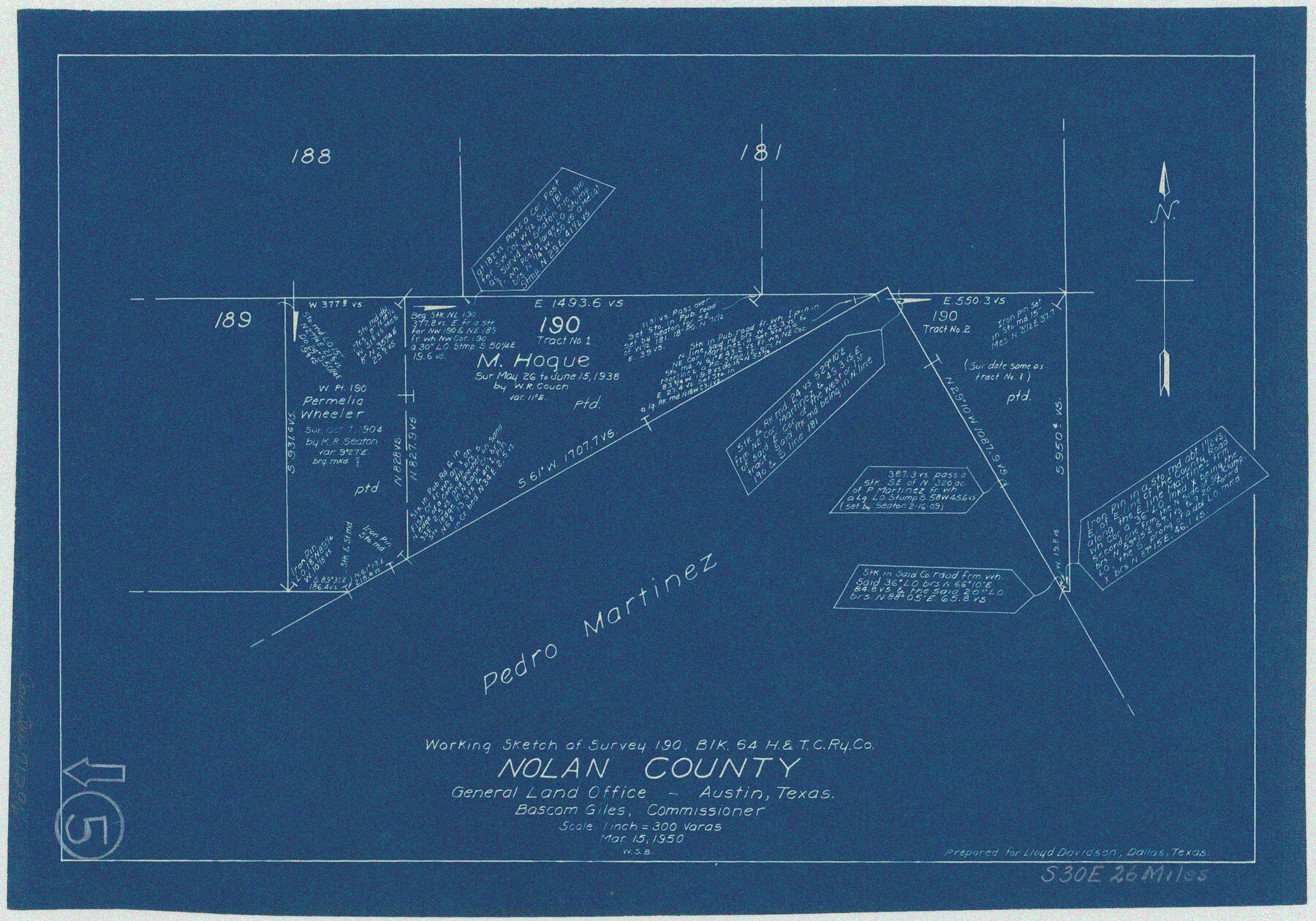
Nolan County Working Sketch 5
-
Map/Doc
71296
-
Collection
General Map Collection
-
Object Dates
3/15/1950 (Creation Date)
-
People and Organizations
W. S. Brewington (Draftsman)
-
Counties
Nolan
-
Subjects
Surveying Working Sketch
-
Height x Width
9.7 x 13.9 inches
24.6 x 35.3 cm
-
Scale
1" = 300 varas
Part of: General Map Collection
Main Line Routes of the Santa Fe Lines

Main Line Routes of the Santa Fe Lines
Size 12.1 x 18.1 inches
Map/Doc 94157
Schleicher County Sketch File 12

Print $8.00
- Digital $50.00
Schleicher County Sketch File 12
1915
Size 14.3 x 8.9 inches
Map/Doc 36489
Portion of States Submerged Area in Matagorda Bay

Print $20.00
- Digital $50.00
Portion of States Submerged Area in Matagorda Bay
1922
Size 13.9 x 14.7 inches
Map/Doc 2952
Zapata County Working Sketch 16

Print $20.00
- Digital $50.00
Zapata County Working Sketch 16
1969
Size 26.1 x 28.3 inches
Map/Doc 62067
Trinity River, Big Creek Sheet

Print $40.00
- Digital $50.00
Trinity River, Big Creek Sheet
1924
Size 48.0 x 36.4 inches
Map/Doc 65179
Presidio County Rolled Sketch 131A

Print $20.00
- Digital $50.00
Presidio County Rolled Sketch 131A
1975
Size 30.5 x 24.9 inches
Map/Doc 10706
Glasscock County Working Sketch 1

Print $20.00
- Digital $50.00
Glasscock County Working Sketch 1
Size 26.6 x 43.0 inches
Map/Doc 63174
Edwards County Boundary File 29

Print $22.00
- Digital $50.00
Edwards County Boundary File 29
Size 15.4 x 31.0 inches
Map/Doc 65502
Aransas County Sketch File 9

Print $40.00
- Digital $50.00
Aransas County Sketch File 9
Size 17.5 x 19.8 inches
Map/Doc 10819
Jefferson County Rolled Sketch 50

Print $20.00
- Digital $50.00
Jefferson County Rolled Sketch 50
Size 34.2 x 41.6 inches
Map/Doc 9306
Harris County Rolled Sketch 96C

Print $3.00
- Digital $50.00
Harris County Rolled Sketch 96C
Size 10.5 x 10.5 inches
Map/Doc 10653
Crockett County Working Sketch 15

Print $20.00
- Digital $50.00
Crockett County Working Sketch 15
1916
Size 16.2 x 20.4 inches
Map/Doc 68348
You may also like
Map of Travis County

Print $20.00
- Digital $50.00
Map of Travis County
1861
Size 21.2 x 25.3 inches
Map/Doc 4087
Brown County Working Sketch 2

Print $20.00
- Digital $50.00
Brown County Working Sketch 2
1919
Size 17.0 x 17.5 inches
Map/Doc 67767
Comanche County Working Sketch 13

Print $20.00
- Digital $50.00
Comanche County Working Sketch 13
1957
Size 18.4 x 15.0 inches
Map/Doc 68147
Galveston County NRC Article 33.136 Sketch 68

Print $34.00
- Digital $50.00
Galveston County NRC Article 33.136 Sketch 68
2008
Size 24.0 x 36.0 inches
Map/Doc 94840
Revised Map of Calvert, Robertson County, Texas

Print $20.00
- Digital $50.00
Revised Map of Calvert, Robertson County, Texas
Size 25.4 x 19.4 inches
Map/Doc 88741
Nolan County Sketch File 11

Print $20.00
- Digital $50.00
Nolan County Sketch File 11
1902
Size 18.5 x 37.5 inches
Map/Doc 42162
Field Notes of surveys in Hutchinson and Wheeler Counties

Field Notes of surveys in Hutchinson and Wheeler Counties
Map/Doc 81670
Tom Green County Rolled Sketch 3

Print $20.00
- Digital $50.00
Tom Green County Rolled Sketch 3
Size 26.8 x 32.8 inches
Map/Doc 7993
Nueces County Rolled Sketch 34

Print $20.00
- Digital $50.00
Nueces County Rolled Sketch 34
1951
Size 47.9 x 37.5 inches
Map/Doc 9601
Carte du Chemin de Fer de Galveston, Houston et Henderson

Print $20.00
- Digital $50.00
Carte du Chemin de Fer de Galveston, Houston et Henderson
1857
Size 35.4 x 27.2 inches
Map/Doc 89274
Sheet 5 copied from Champlin Book 5 [Strip Map showing T. & P. connecting lines]
![93180, Sheet 5 copied from Champlin Book 5 [Strip Map showing T. & P. connecting lines], Twichell Survey Records](https://historictexasmaps.com/wmedia_w700/maps/93180-1.tif.jpg)
Print $40.00
- Digital $50.00
Sheet 5 copied from Champlin Book 5 [Strip Map showing T. & P. connecting lines]
1909
Size 7.9 x 75.6 inches
Map/Doc 93180
[West line of Randall County]
![91705, [West line of Randall County], Twichell Survey Records](https://historictexasmaps.com/wmedia_w700/maps/91705-1.tif.jpg)
Print $20.00
- Digital $50.00
[West line of Randall County]
Size 4.2 x 19.9 inches
Map/Doc 91705