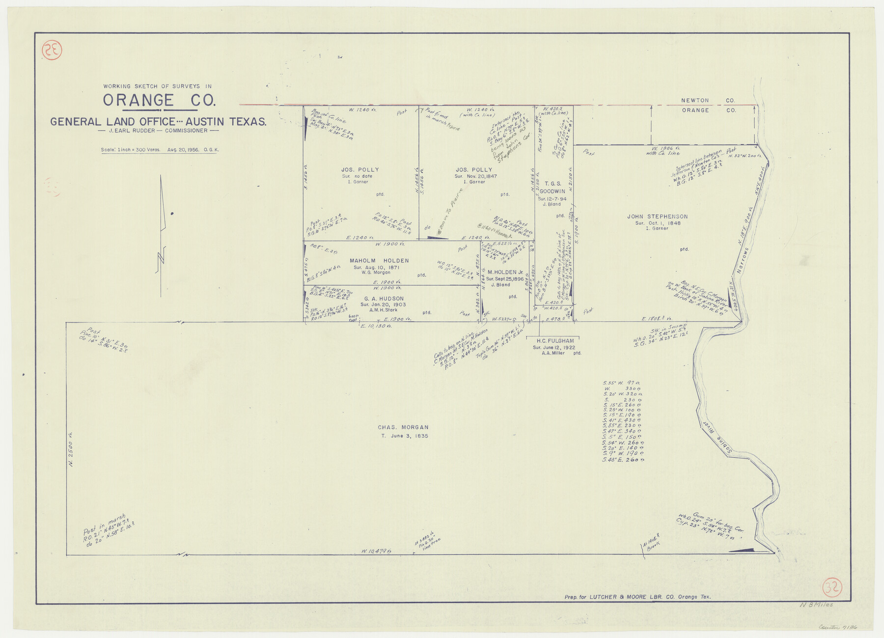
Orange County Working Sketch 32
-
Map/Doc
71364
-
Collection
General Map Collection
-
Object Dates
8/20/1956 (Creation Date)
-
People and Organizations
Otto G. Kurio (Draftsman)
-
Counties
Orange
-
Subjects
Surveying Working Sketch
-
Height x Width
22.9 x 31.7 inches
58.2 x 80.5 cm
-
Scale
1" = 300 varas
Part of: General Map Collection
Eastland County

Print $20.00
- Digital $50.00
Eastland County
1879
Size 21.3 x 21.3 inches
Map/Doc 3499
Haskell County Sketch File 16

Print $32.00
- Digital $50.00
Haskell County Sketch File 16
1894
Size 11.2 x 8.8 inches
Map/Doc 26163
Hardin County Sketch File 45

Print $2.00
- Digital $50.00
Hardin County Sketch File 45
Size 8.3 x 6.2 inches
Map/Doc 25195
Flight Mission No. DQN-5K, Frame 27, Calhoun County

Print $20.00
- Digital $50.00
Flight Mission No. DQN-5K, Frame 27, Calhoun County
1953
Size 18.4 x 22.1 inches
Map/Doc 84378
Flight Mission No. CRK-3P, Frame 70, Refugio County

Print $20.00
- Digital $50.00
Flight Mission No. CRK-3P, Frame 70, Refugio County
1956
Size 18.6 x 22.5 inches
Map/Doc 86912

Presidio County Working Sketch 9

Print $20.00
- Digital $50.00
Presidio County Working Sketch 9
1928
Size 40.7 x 18.5 inches
Map/Doc 71683
Kinney County Sketch File E1

Print $20.00
- Digital $50.00
Kinney County Sketch File E1
1885
Size 29.8 x 31.9 inches
Map/Doc 10619
Baylor County Working Sketch Graphic Index

Print $20.00
- Digital $50.00
Baylor County Working Sketch Graphic Index
1961
Size 41.1 x 33.6 inches
Map/Doc 76463
Yoakum County Rolled Sketch 1

Print $20.00
- Digital $50.00
Yoakum County Rolled Sketch 1
1939
Size 40.5 x 37.5 inches
Map/Doc 10162
Pecos County Sketch File 108

Print $4.00
- Digital $50.00
Pecos County Sketch File 108
1974
Size 14.3 x 8.6 inches
Map/Doc 34037
Houston County Sketch File 5a

Print $5.00
- Digital $50.00
Houston County Sketch File 5a
Size 8.5 x 9.4 inches
Map/Doc 26758
You may also like
Haskell County Working Sketch 17

Print $20.00
- Digital $50.00
Haskell County Working Sketch 17
2011
Size 34.3 x 32.3 inches
Map/Doc 89989
Roberts Addition to the City of Morton

Print $3.00
- Digital $50.00
Roberts Addition to the City of Morton
1958
Size 11.8 x 11.4 inches
Map/Doc 92540
G & H Blocks, Gaines County, Texas Resurvey

Print $40.00
- Digital $50.00
G & H Blocks, Gaines County, Texas Resurvey
1915
Size 58.4 x 34.1 inches
Map/Doc 89668
Reagan County Working Sketch 24

Print $20.00
- Digital $50.00
Reagan County Working Sketch 24
1958
Size 45.4 x 39.9 inches
Map/Doc 71866
Pecos County Working Sketch 27

Print $40.00
- Digital $50.00
Pecos County Working Sketch 27
1929
Size 36.9 x 50.8 inches
Map/Doc 71498

The Republic County of Harris. May 15, 1838

Print $20.00
The Republic County of Harris. May 15, 1838
2020
Size 17.7 x 21.7 inches
Map/Doc 96163
[Capitol Leagues 633- 664]
![91076, [Capitol Leagues 633- 664], Twichell Survey Records](https://historictexasmaps.com/wmedia_w700/maps/91076-1.tif.jpg)
Print $20.00
- Digital $50.00
[Capitol Leagues 633- 664]
Size 17.0 x 14.6 inches
Map/Doc 91076
Flight Mission No. BQR-3K, Frame 158, Brazoria County

Print $20.00
- Digital $50.00
Flight Mission No. BQR-3K, Frame 158, Brazoria County
1952
Size 18.7 x 22.4 inches
Map/Doc 83985
Hall County Sketch File 7

Print $20.00
- Digital $50.00
Hall County Sketch File 7
1890
Size 12.0 x 22.4 inches
Map/Doc 11603
Flight Mission No. DAG-24K, Frame 129, Matagorda County

Print $20.00
- Digital $50.00
Flight Mission No. DAG-24K, Frame 129, Matagorda County
1953
Size 18.5 x 22.2 inches
Map/Doc 86547
Tom Green County Working Sketch 8

Print $20.00
- Digital $50.00
Tom Green County Working Sketch 8
1950
Size 24.8 x 20.9 inches
Map/Doc 69377