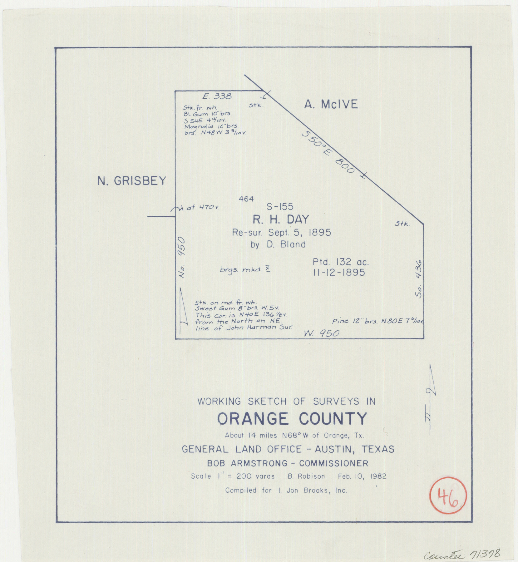
Orange County Working Sketch 46
-
Map/Doc
71378
-
Collection
General Map Collection
-
Object Dates
2/10/1982 (Creation Date)
-
People and Organizations
Beverly Robison (Draftsman)
-
Counties
Orange
-
Subjects
Surveying Working Sketch
-
Height x Width
10.8 x 9.9 inches
27.4 x 25.2 cm
-
Scale
1" = 200 varas
Part of: General Map Collection
San Patricio County Rolled Sketch 33

Print $141.00
- Digital $50.00
San Patricio County Rolled Sketch 33
Size 10.2 x 15.0 inches
Map/Doc 48874
Jefferson Co.

Print $40.00
- Digital $50.00
Jefferson Co.
1978
Size 48.2 x 42.7 inches
Map/Doc 73196
Kendall County Working Sketch 3

Print $20.00
- Digital $50.00
Kendall County Working Sketch 3
1941
Size 18.0 x 18.3 inches
Map/Doc 66675
Galveston County NRC Article 33.136 Sketch 65

Print $28.00
- Digital $50.00
Galveston County NRC Article 33.136 Sketch 65
2012
Size 24.0 x 36.0 inches
Map/Doc 93328
Map of Clay County, Cooke Land District, formely(sic.) Fannin Land District

Print $20.00
- Digital $50.00
Map of Clay County, Cooke Land District, formely(sic.) Fannin Land District
1859
Size 30.2 x 19.0 inches
Map/Doc 1049
Stonewall County Working Sketch 1

Print $20.00
- Digital $50.00
Stonewall County Working Sketch 1
1910
Size 30.7 x 22.8 inches
Map/Doc 63995
Dickens County Sketch File D

Print $20.00
- Digital $50.00
Dickens County Sketch File D
1883
Size 15.7 x 14.8 inches
Map/Doc 11330
[Center Line of the Texas and Pacific Railroad Company 16 Mile Reserve]
![3125, [Center Line of the Texas and Pacific Railroad Company 16 Mile Reserve], General Map Collection](https://historictexasmaps.com/wmedia_w700/maps/3125-1.tif.jpg)
Print $40.00
- Digital $50.00
[Center Line of the Texas and Pacific Railroad Company 16 Mile Reserve]
1876
Size 43.1 x 55.6 inches
Map/Doc 3125
Pecos County Sketch File 101

Print $40.00
- Digital $50.00
Pecos County Sketch File 101
1960
Size 15.6 x 11.7 inches
Map/Doc 34012
Brazoria County NRC Article 33.136 Sketch 20

Print $36.00
- Digital $50.00
Brazoria County NRC Article 33.136 Sketch 20
2020
Map/Doc 96878
Marion County Working Sketch Graphic Index, Sheet 1 (Sketches 1 to 26)

Print $20.00
- Digital $50.00
Marion County Working Sketch Graphic Index, Sheet 1 (Sketches 1 to 26)
1943
Size 26.8 x 45.1 inches
Map/Doc 76629
[Maps of surveys in Reeves & Culberson Cos]
![61143, [Maps of surveys in Reeves & Culberson Cos], General Map Collection](https://historictexasmaps.com/wmedia_w700/maps/61143.tif.jpg)
Print $20.00
- Digital $50.00
[Maps of surveys in Reeves & Culberson Cos]
1937
Size 30.7 x 24.9 inches
Map/Doc 61143
You may also like
La Salle County Rolled Sketch 21

Print $77.00
- Digital $50.00
La Salle County Rolled Sketch 21
1955
Size 10.0 x 15.1 inches
Map/Doc 46461
Baylor County Boundary File 1

Print $25.00
- Digital $50.00
Baylor County Boundary File 1
Size 9.3 x 8.4 inches
Map/Doc 50347
Upton County Sketch File 9

Print $30.00
- Digital $50.00
Upton County Sketch File 9
1913
Size 9.3 x 5.9 inches
Map/Doc 38824
Dépt. de la Nièvre

Print $20.00
- Digital $50.00
Dépt. de la Nièvre
Size 14.5 x 20.3 inches
Map/Doc 94452
Wharton County Sketch File 4

Print $20.00
- Digital $50.00
Wharton County Sketch File 4
Size 26.9 x 16.2 inches
Map/Doc 12659
Polk County Sketch File 44

Print $193.00
- Digital $50.00
Polk County Sketch File 44
1958
Size 9.4 x 11.0 inches
Map/Doc 34297
Orange County Sketch File 39

Print $20.00
- Digital $50.00
Orange County Sketch File 39
1964
Size 24.2 x 27.9 inches
Map/Doc 12127
Dallam Co. Texas, Standard Single County Oil Development Survey

Print $20.00
- Digital $50.00
Dallam Co. Texas, Standard Single County Oil Development Survey
Size 20.7 x 15.8 inches
Map/Doc 90583
Map of Walker County

Print $20.00
- Digital $50.00
Map of Walker County
1858
Size 22.9 x 34.1 inches
Map/Doc 4120
Brazoria County Rolled Sketch 46

Print $40.00
- Digital $50.00
Brazoria County Rolled Sketch 46
1950
Size 30.7 x 57.3 inches
Map/Doc 8462
[Notes and map showing Public School Land Block K between Yoakum and Terry Counties]
![92011, [Notes and map showing Public School Land Block K between Yoakum and Terry Counties], Twichell Survey Records](https://historictexasmaps.com/wmedia_w700/maps/92011-1.tif.jpg)
Print $20.00
- Digital $50.00
[Notes and map showing Public School Land Block K between Yoakum and Terry Counties]
1902
Size 17.1 x 30.9 inches
Map/Doc 92011
Reeves County Rolled Sketch 29

Print $20.00
- Digital $50.00
Reeves County Rolled Sketch 29
1986
Size 21.6 x 27.5 inches
Map/Doc 7498