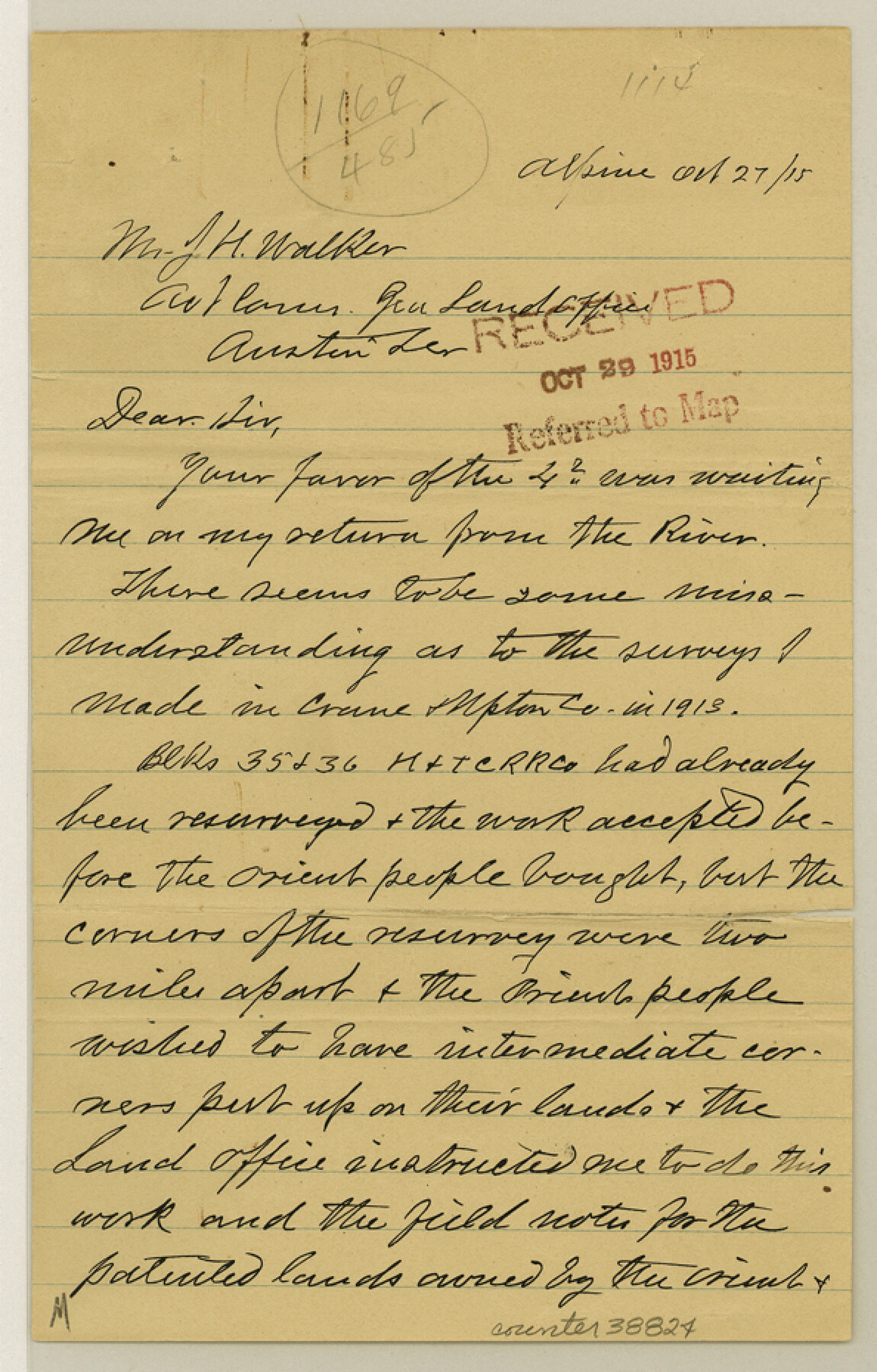
Upton County Sketch File 9
[Contract for surveying between Trustee Union Land Company and R. S. Dod]
-
Map/Doc
38824
-
Collection
General Map Collection
-
Object Dates
1913/7/1 (Creation Date)
1913/7/1 (Creation Date)
1913/7/1 (Correspondence Date)
1915/10/27 (Correspondence Date)
1915/6/25 (Correspondence Date)
1913/4/10 (Correspondence Date)
1913/3/12 (Correspondence Date)
-
People and Organizations
J.T. Robison (GLO Commissioner)
R.S. Dod (Surveyor/Engineer)
-
Counties
Upton
-
Subjects
Surveying Sketch File
-
Height x Width
9.3 x 5.9 inches
23.6 x 15.0 cm
-
Medium
multi-page, multi-format
-
Features
Hurdle Station Railroad
Pecos River
Part of: General Map Collection
Fisher County Sketch File 21

Print $6.00
- Digital $50.00
Fisher County Sketch File 21
Size 10.3 x 17.0 inches
Map/Doc 22649
A Topographical Map of the Government Tract Adjoining the City of Austin

Print $20.00
- Digital $50.00
A Topographical Map of the Government Tract Adjoining the City of Austin
1840
Size 44.1 x 38.4 inches
Map/Doc 2178
Map of Lampasas County

Print $20.00
- Digital $50.00
Map of Lampasas County
1856
Size 19.7 x 25.3 inches
Map/Doc 3792
Kent County Working Sketch 18

Print $20.00
- Digital $50.00
Kent County Working Sketch 18
1974
Size 33.5 x 31.5 inches
Map/Doc 70025
Stephens County Boundary File 2

Print $34.00
- Digital $50.00
Stephens County Boundary File 2
Size 14.2 x 8.7 inches
Map/Doc 58866
Reeves County Sketch File 7

Print $20.00
- Digital $50.00
Reeves County Sketch File 7
Size 18.3 x 19.9 inches
Map/Doc 12243
Copy of Surveyor's Field Book, Morris Browning - In Blocks 7, 5 & 4, I&GNRRCo., Hutchinson and Carson Counties, Texas

Print $2.00
- Digital $50.00
Copy of Surveyor's Field Book, Morris Browning - In Blocks 7, 5 & 4, I&GNRRCo., Hutchinson and Carson Counties, Texas
1888
Size 7.0 x 8.8 inches
Map/Doc 62278
Histoire de la Louisiane et de la Cession de Cette Colonie par la France aux États-Unis de l'Amérique Septentrionale

Histoire de la Louisiane et de la Cession de Cette Colonie par la France aux États-Unis de l'Amérique Septentrionale
1829
Map/Doc 97259
United States - Gulf Coast Texas - Southern part of Laguna Madre

Print $20.00
- Digital $50.00
United States - Gulf Coast Texas - Southern part of Laguna Madre
1941
Size 26.5 x 18.3 inches
Map/Doc 72955
Caldwell County Sketch File 4a

Print $8.00
- Digital $50.00
Caldwell County Sketch File 4a
1898
Size 11.2 x 8.8 inches
Map/Doc 35835
Burleson County Working Sketch 46

Print $20.00
- Digital $50.00
Burleson County Working Sketch 46
1995
Size 30.6 x 36.9 inches
Map/Doc 67765
Maps of Gulf Intracoastal Waterway, Texas - Sabine River to the Rio Grande and connecting waterways including ship channels

Print $20.00
- Digital $50.00
Maps of Gulf Intracoastal Waterway, Texas - Sabine River to the Rio Grande and connecting waterways including ship channels
1966
Size 14.7 x 21.0 inches
Map/Doc 61992
You may also like
El Paso County Sketch File 35 (6)

Print $20.00
- Digital $50.00
El Paso County Sketch File 35 (6)
1886
Size 20.3 x 36.9 inches
Map/Doc 11460
Stonewall County Rolled Sketch 11A

Print $20.00
- Digital $50.00
Stonewall County Rolled Sketch 11A
Size 33.4 x 28.2 inches
Map/Doc 7868
Jefferson County Sketch File 44

Print $20.00
- Digital $50.00
Jefferson County Sketch File 44
1917
Size 22.8 x 32.9 inches
Map/Doc 11878
Flight Mission No. BQR-13K, Frame 22, Brazoria County

Print $20.00
- Digital $50.00
Flight Mission No. BQR-13K, Frame 22, Brazoria County
1952
Size 18.9 x 22.4 inches
Map/Doc 84070
Nueces County Sketch File 46

Print $44.00
- Digital $50.00
Nueces County Sketch File 46
1907
Size 11.1 x 8.7 inches
Map/Doc 32643
Sabine River, Kane Bridge Sheet

Print $4.00
- Digital $50.00
Sabine River, Kane Bridge Sheet
Size 20.9 x 24.2 inches
Map/Doc 65135
Denton County Sketch File 39

Print $16.00
- Digital $50.00
Denton County Sketch File 39
1934
Size 7.8 x 8.9 inches
Map/Doc 20781
Dimmit County

Print $40.00
- Digital $50.00
Dimmit County
1976
Size 42.2 x 48.9 inches
Map/Doc 77265
Liberty County Working Sketch 24

Print $20.00
- Digital $50.00
Liberty County Working Sketch 24
1941
Size 19.0 x 14.0 inches
Map/Doc 70483
Presidio County Sketch File 49

Print $6.00
- Digital $50.00
Presidio County Sketch File 49
1919
Size 14.6 x 11.9 inches
Map/Doc 34584
Bee County Sketch File 26

Print $6.00
- Digital $50.00
Bee County Sketch File 26
1883
Size 14.5 x 9.0 inches
Map/Doc 14328
