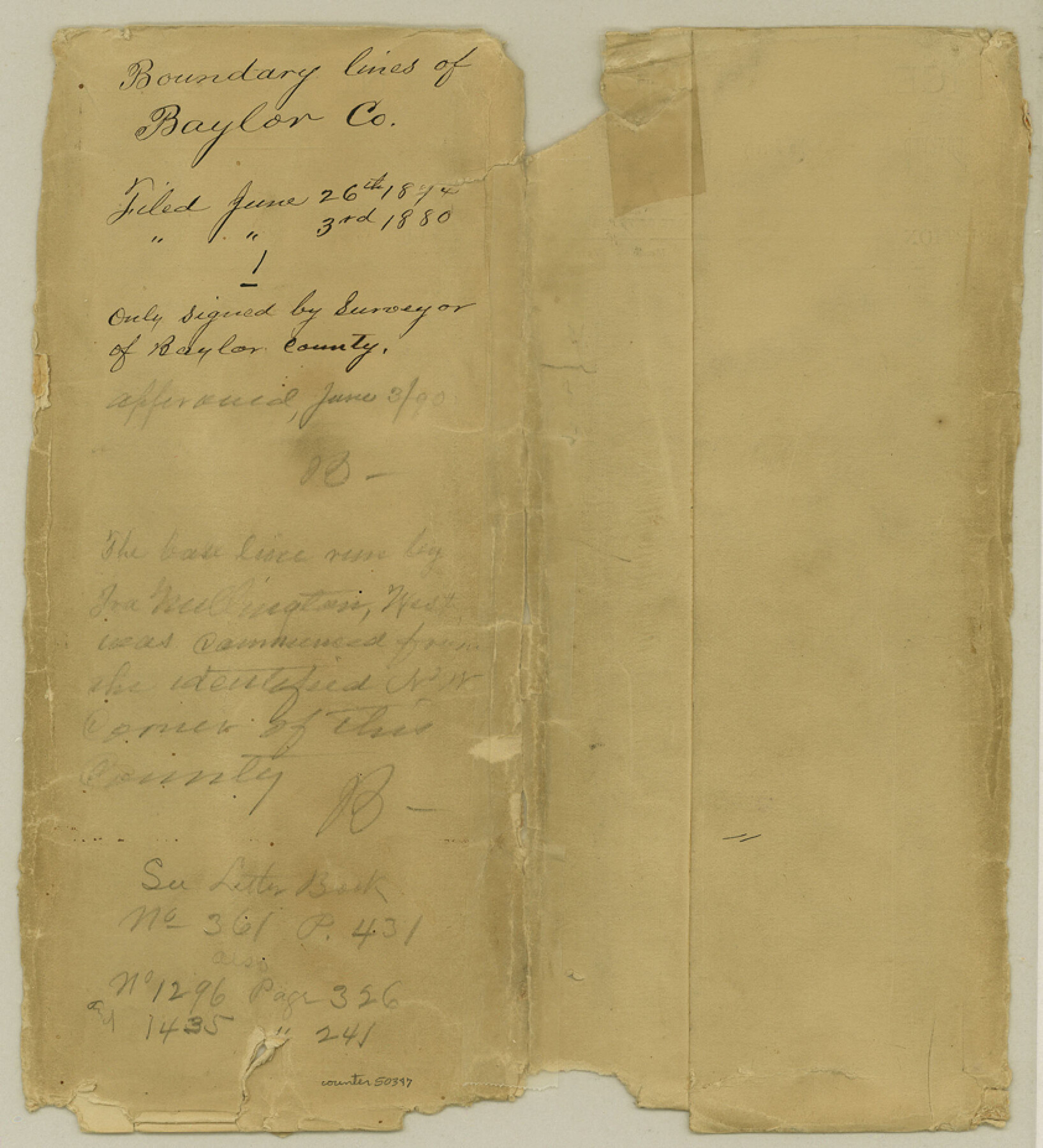
Baylor County Boundary File 1
Plat and Fieldnotes of the south Boundary Line of Baylor County
-
Map/Doc
50347
-
Collection
General Map Collection
-
Counties
Baylor
-
Subjects
County Boundaries
-
Height x Width
9.3 x 8.4 inches
23.6 x 21.3 cm
Part of: General Map Collection
Upton County Sketch File 35

Print $14.00
- Digital $50.00
Upton County Sketch File 35
1942
Size 11.4 x 8.8 inches
Map/Doc 38886
Liberty County Working Sketch 68

Print $20.00
- Digital $50.00
Liberty County Working Sketch 68
1972
Size 27.4 x 24.6 inches
Map/Doc 70528
Galveston County Rolled Sketch 28

Print $347.00
- Digital $50.00
Galveston County Rolled Sketch 28
Size 22.6 x 18.1 inches
Map/Doc 6068
Lay's Map of the United States

Print $40.00
- Digital $50.00
Lay's Map of the United States
Size 55.0 x 61.7 inches
Map/Doc 95693
Cameron County Working Sketch 3

Print $20.00
- Digital $50.00
Cameron County Working Sketch 3
1964
Size 40.8 x 38.6 inches
Map/Doc 67882
Map of the Mississippi River from its Source to the Mouth of the Missouri

Print $20.00
- Digital $50.00
Map of the Mississippi River from its Source to the Mouth of the Missouri
1810
Size 10.4 x 31.3 inches
Map/Doc 95153
Map of Hill County

Print $20.00
- Digital $50.00
Map of Hill County
1884
Size 47.2 x 36.8 inches
Map/Doc 16851
Orange County Sketch File 43

Print $4.00
- Digital $50.00
Orange County Sketch File 43
1873
Size 8.2 x 10.3 inches
Map/Doc 33385
Palo Pinto County

Print $20.00
- Digital $50.00
Palo Pinto County
1941
Size 44.9 x 35.9 inches
Map/Doc 77389
Gaines County

Print $40.00
- Digital $50.00
Gaines County
1901
Size 41.3 x 57.2 inches
Map/Doc 16833
Nueces County Rolled Sketch 24

Print $20.00
- Digital $50.00
Nueces County Rolled Sketch 24
Size 19.6 x 24.8 inches
Map/Doc 6873

You may also like
San Augustine County Working Sketch 19

Print $20.00
- Digital $50.00
San Augustine County Working Sketch 19
1967
Size 22.9 x 30.6 inches
Map/Doc 63707
Liberty County Working Sketch 35

Print $20.00
- Digital $50.00
Liberty County Working Sketch 35
1948
Size 22.3 x 42.3 inches
Map/Doc 70494
Gaines County Working Sketch 11

Print $40.00
- Digital $50.00
Gaines County Working Sketch 11
1953
Size 68.4 x 33.4 inches
Map/Doc 69311
Nueces County Rolled Sketch 61

Print $20.00
- Digital $50.00
Nueces County Rolled Sketch 61
1977
Size 32.2 x 39.3 inches
Map/Doc 6907

Presidio County Rolled Sketch 22A

Print $20.00
- Digital $50.00
Presidio County Rolled Sketch 22A
1909
Size 20.6 x 31.9 inches
Map/Doc 7332
Dallas County Working Sketch 19

Print $20.00
- Digital $50.00
Dallas County Working Sketch 19
1997
Size 23.1 x 30.3 inches
Map/Doc 68585
Kaufman County State Real Property Sketch 1

Print $92.00
- Digital $50.00
Kaufman County State Real Property Sketch 1
2006
Size 24.6 x 35.4 inches
Map/Doc 88624
General Highway Map, Rains County, Texas

Print $20.00
General Highway Map, Rains County, Texas
1961
Size 18.1 x 24.4 inches
Map/Doc 79634
The Republic County of Brazoria. December 29, 1845

Print $20.00
The Republic County of Brazoria. December 29, 1845
2020
Size 14.7 x 21.8 inches
Map/Doc 96115
Flight Mission No. CUG-2P, Frame 23, Kleberg County

Print $20.00
- Digital $50.00
Flight Mission No. CUG-2P, Frame 23, Kleberg County
1956
Size 18.6 x 22.3 inches
Map/Doc 86187
Map of Dalhart

Print $20.00
- Digital $50.00
Map of Dalhart
1905
Size 23.5 x 32.0 inches
Map/Doc 92146