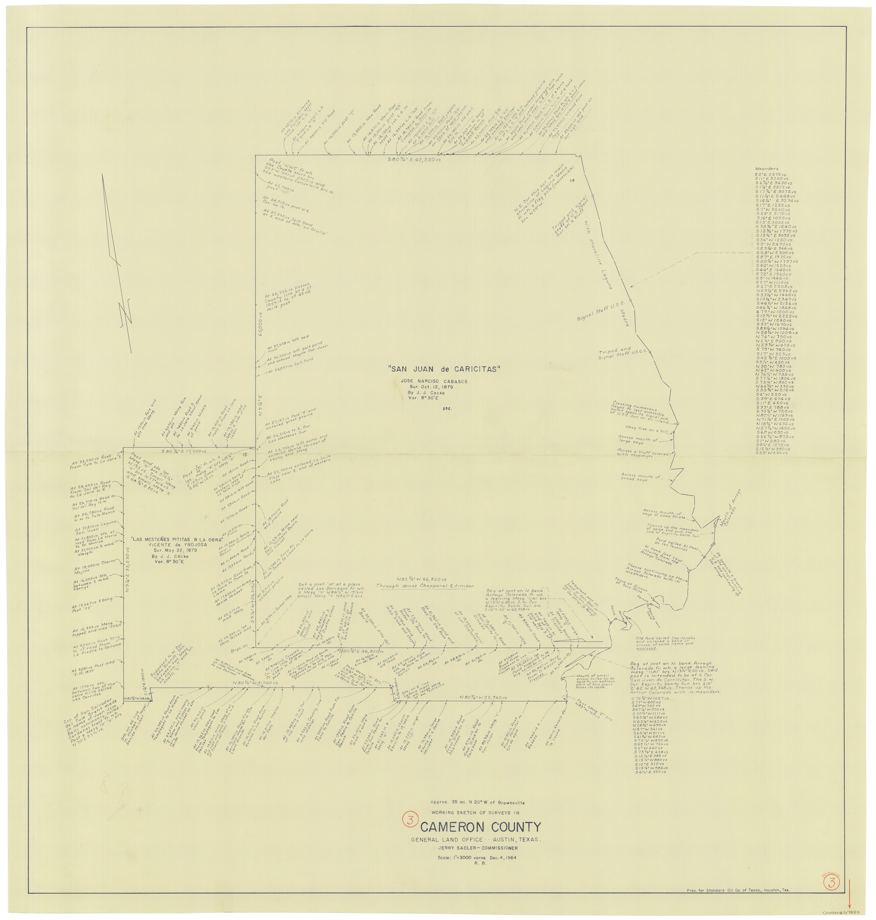
Cameron County Working Sketch 3
-
Map/Doc
67882
-
Collection
General Map Collection
-
Object Dates
12/4/1964 (Creation Date)
-
Counties
Cameron
-
Subjects
Surveying Working Sketch
-
Height x Width
40.8 x 38.6 inches
103.6 x 98.0 cm
-
Scale
1" = 3000 varas
Part of: General Map Collection
Texas 1971 Official State Highway Map

Digital $50.00
Texas 1971 Official State Highway Map
Size 27.9 x 36.3 inches
Map/Doc 94315
Hood County Working Sketch 30

Print $20.00
- Digital $50.00
Hood County Working Sketch 30
1990
Size 26.6 x 29.9 inches
Map/Doc 66224
Polk County Working Sketch 33a

Print $20.00
- Digital $50.00
Polk County Working Sketch 33a
1960
Size 30.7 x 27.4 inches
Map/Doc 71649
Presidio County Rolled Sketch 102

Print $20.00
- Digital $50.00
Presidio County Rolled Sketch 102
1957
Size 19.3 x 13.8 inches
Map/Doc 7385
Terrell County Rolled Sketch 41

Print $20.00
- Digital $50.00
Terrell County Rolled Sketch 41
Size 18.6 x 34.3 inches
Map/Doc 9990
Presidio County Working Sketch 14

Print $20.00
- Digital $50.00
Presidio County Working Sketch 14
1942
Size 10.9 x 17.7 inches
Map/Doc 71690
Webb County Rolled Sketch 36

Print $20.00
- Digital $50.00
Webb County Rolled Sketch 36
1940
Size 12.8 x 24.2 inches
Map/Doc 8191
Medina County Working Sketch 25

Print $20.00
- Digital $50.00
Medina County Working Sketch 25
1985
Size 37.6 x 42.9 inches
Map/Doc 70940
Burleson County Working Sketch 25

Print $20.00
- Digital $50.00
Burleson County Working Sketch 25
1981
Size 27.9 x 31.0 inches
Map/Doc 67744
Hemphill County Rolled Sketch MJ

Print $20.00
- Digital $50.00
Hemphill County Rolled Sketch MJ
Size 21.3 x 41.4 inches
Map/Doc 6201
Medina County Working Sketch 16

Print $20.00
- Digital $50.00
Medina County Working Sketch 16
1979
Size 27.1 x 28.2 inches
Map/Doc 70931
Tom Green County Sketch File 79A

Print $4.00
- Digital $50.00
Tom Green County Sketch File 79A
1970
Size 14.5 x 8.8 inches
Map/Doc 38258
You may also like
Victoria County Rolled Sketch 6

Print $20.00
- Digital $50.00
Victoria County Rolled Sketch 6
Size 27.9 x 36.3 inches
Map/Doc 8152
Webb County Working Sketch 63

Print $20.00
- Digital $50.00
Webb County Working Sketch 63
1962
Size 11.1 x 24.2 inches
Map/Doc 72429
Hudspeth County Sketch File 4a

Print $22.00
- Digital $50.00
Hudspeth County Sketch File 4a
1858
Size 16.4 x 14.3 inches
Map/Doc 26889
Collin County Sketch File 7

Print $40.00
- Digital $50.00
Collin County Sketch File 7
1852
Size 17.3 x 14.0 inches
Map/Doc 18866
Webb County Sketch File 12-1

Print $16.00
- Digital $50.00
Webb County Sketch File 12-1
1886
Size 13.0 x 8.3 inches
Map/Doc 39793
Map of Erath County

Print $20.00
- Digital $50.00
Map of Erath County
1856
Size 22.4 x 28.0 inches
Map/Doc 3519
Copy of Surveyor's Field Book, Morris Browning - In Blocks 7, 5 & 4, I&GNRRCo., Hutchinson and Carson Counties, Texas

Print $2.00
- Digital $50.00
Copy of Surveyor's Field Book, Morris Browning - In Blocks 7, 5 & 4, I&GNRRCo., Hutchinson and Carson Counties, Texas
1888
Size 6.9 x 8.9 inches
Map/Doc 62273
King County Survey

Print $20.00
- Digital $50.00
King County Survey
1916
Size 25.4 x 30.1 inches
Map/Doc 91020
Hall County Sketch File B1

Print $20.00
- Digital $50.00
Hall County Sketch File B1
1904
Size 23.4 x 25.4 inches
Map/Doc 11612
Map of Texas in 1836

Print $20.00
- Digital $50.00
Map of Texas in 1836
1936
Size 24.5 x 19.3 inches
Map/Doc 449
Map of Hale County, Texas

Print $2.00
- Digital $50.00
Map of Hale County, Texas
1903
Size 9.2 x 11.6 inches
Map/Doc 90698
Harris County Sketch File 95

Print $20.00
- Digital $50.00
Harris County Sketch File 95
1952
Size 31.6 x 17.1 inches
Map/Doc 11678