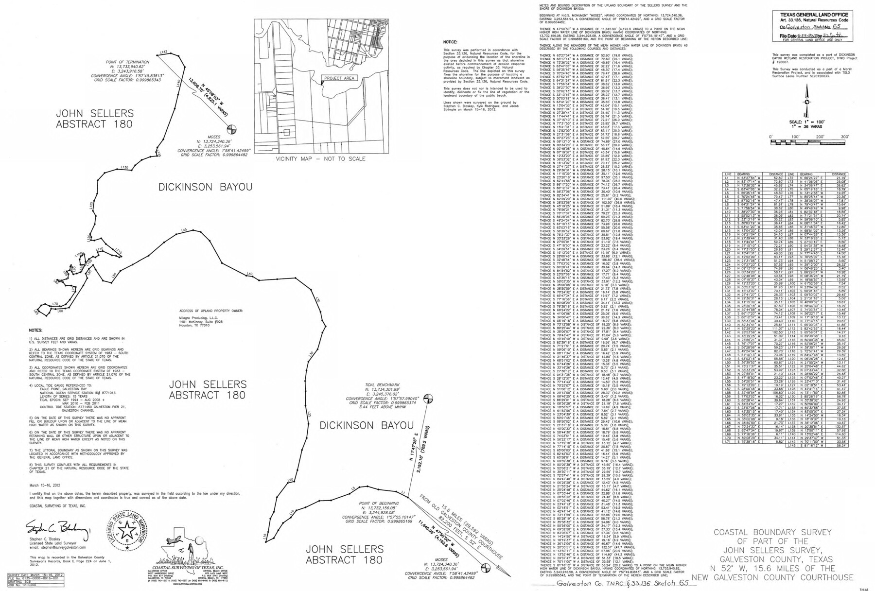
Galveston County NRC Article 33.136 Sketch 65
Coastal boundary survey of part of the John Sellers survey, Galveston County, Texas
-
Map/Doc
93328
-
Collection
General Map Collection
-
Object Dates
2012/3/16 (Creation Date)
2012/6/29 (File Date)
-
People and Organizations
Stephen C. Blaskey (Surveyor/Engineer)
-
Counties
Galveston
-
Subjects
Surveying CBS
-
Height x Width
24.0 x 36.0 inches
61.0 x 91.4 cm
-
Medium
multi-page, multi-format
-
Comments
Project: Dickinson Bayou Wetland Restoration Project No.: SL20120033 (GLO) 126007 (Texas Parks and Wildlife)
Part of: General Map Collection
Castro County Sketch File 4k

Print $4.00
- Digital $50.00
Castro County Sketch File 4k
Size 13.6 x 8.6 inches
Map/Doc 17485
Hudspeth County Rolled Sketch 13
Print $40.00
- Digital $50.00
Hudspeth County Rolled Sketch 13
1885
Size 22.6 x 62.1 inches
Map/Doc 9201
Edwards County Working Sketch 99

Print $20.00
- Digital $50.00
Edwards County Working Sketch 99
1970
Size 36.3 x 27.9 inches
Map/Doc 68975
Flight Mission No. CUG-3P, Frame 83, Kleberg County

Print $20.00
- Digital $50.00
Flight Mission No. CUG-3P, Frame 83, Kleberg County
1956
Size 18.7 x 22.4 inches
Map/Doc 86258
Galveston County Working Sketch 3

Print $20.00
- Digital $50.00
Galveston County Working Sketch 3
1915
Size 21.4 x 19.5 inches
Map/Doc 69340
Map of Upton County

Print $20.00
- Digital $50.00
Map of Upton County
1889
Size 23.4 x 21.4 inches
Map/Doc 4104
Aransas Pass to Baffin Bay

Print $20.00
- Digital $50.00
Aransas Pass to Baffin Bay
1966
Size 42.3 x 34.9 inches
Map/Doc 73416
Bandera County Working Sketch 16d

Print $20.00
- Digital $50.00
Bandera County Working Sketch 16d
1941
Size 19.1 x 23.2 inches
Map/Doc 67612
Garza County Rolled Sketch 6B

Print $20.00
- Digital $50.00
Garza County Rolled Sketch 6B
Size 27.6 x 36.4 inches
Map/Doc 5996
Cass County Working Sketch 11

Print $3.00
- Digital $50.00
Cass County Working Sketch 11
Size 14.8 x 10.3 inches
Map/Doc 67914
Township 9 North Range 14 West, North Western District, Louisiana

Print $20.00
- Digital $50.00
Township 9 North Range 14 West, North Western District, Louisiana
1854
Size 19.5 x 24.6 inches
Map/Doc 65873
Harris County Rolled Sketch WDC

Print $40.00
- Digital $50.00
Harris County Rolled Sketch WDC
1936
Size 42.7 x 68.4 inches
Map/Doc 9126
You may also like
Liberty County Working Sketch 78

Print $20.00
- Digital $50.00
Liberty County Working Sketch 78
1981
Size 36.2 x 41.0 inches
Map/Doc 70538
Goliad County Rolled Sketch 3

Print $4.00
- Digital $50.00
Goliad County Rolled Sketch 3
1945
Size 24.2 x 26.9 inches
Map/Doc 6024
Fisher County Sketch File 10

Print $20.00
- Digital $50.00
Fisher County Sketch File 10
Size 9.7 x 37.0 inches
Map/Doc 11477
PSL Field Notes for Blocks C38 and C39 in Dawson and Terry Counties, and Block C41 in Dawson, Lynn, and Terry Counties

PSL Field Notes for Blocks C38 and C39 in Dawson and Terry Counties, and Block C41 in Dawson, Lynn, and Terry Counties
Map/Doc 81650
Kaufman County, 1887

Print $20.00
- Digital $50.00
Kaufman County, 1887
1887
Size 42.6 x 46.1 inches
Map/Doc 89701
Brooks County Rolled Sketch 23

Print $40.00
- Digital $50.00
Brooks County Rolled Sketch 23
Size 42.4 x 74.4 inches
Map/Doc 8538
General Highway Map, Nacogdoches County, Texas

Print $20.00
General Highway Map, Nacogdoches County, Texas
1961
Size 19.3 x 25.0 inches
Map/Doc 79607
Montgomery County Sketch File 28

Print $22.00
- Digital $50.00
Montgomery County Sketch File 28
Size 14.1 x 8.7 inches
Map/Doc 31873
Ector County Working Sketch 31

Print $40.00
- Digital $50.00
Ector County Working Sketch 31
1980
Size 36.0 x 51.0 inches
Map/Doc 68874
Sutton County Working Sketch 19

Print $20.00
- Digital $50.00
Sutton County Working Sketch 19
1978
Size 37.7 x 39.0 inches
Map/Doc 62362
Gray County Sketch File B2

Print $20.00
- Digital $50.00
Gray County Sketch File B2
Size 22.8 x 17.3 inches
Map/Doc 11579
Scurry County Working Sketch 3

Print $20.00
- Digital $50.00
Scurry County Working Sketch 3
1941
Size 20.7 x 12.4 inches
Map/Doc 63832