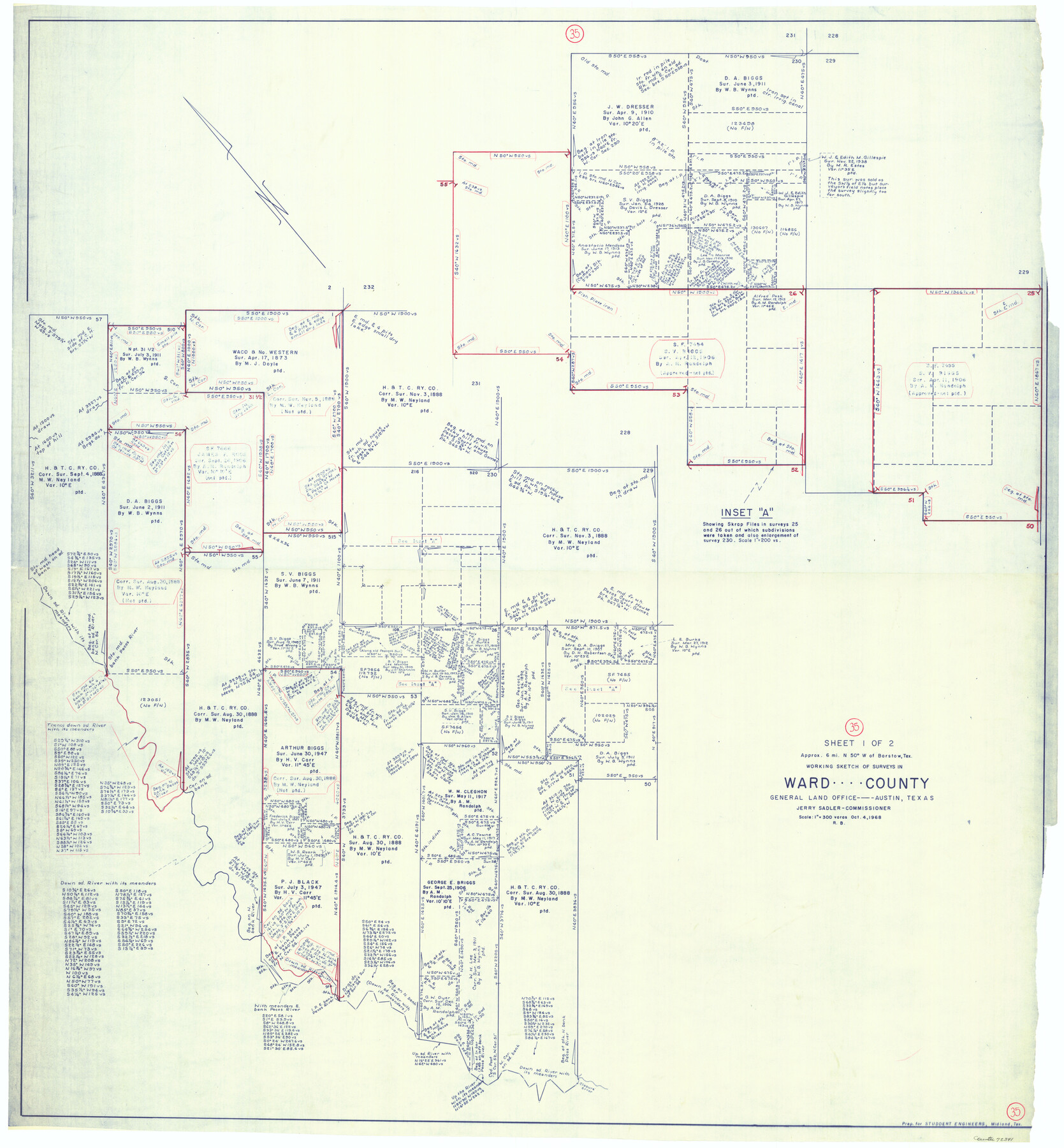
Ward County Working Sketch 35
-
Map/Doc
72341
-
Collection
General Map Collection
-
Object Dates
10/4/1968 (Creation Date)
-
People and Organizations
Roy Buckholts (Draftsman)
-
Counties
Ward
-
Subjects
Surveying Working Sketch
-
Height x Width
46.4 x 43.0 inches
117.9 x 109.2 cm
-
Scale
1" = 300 varas
Part of: General Map Collection
Crockett County Rolled Sketch 46C

Print $20.00
- Digital $50.00
Crockett County Rolled Sketch 46C
Size 24.5 x 23.8 inches
Map/Doc 5595
Flight Mission No. CLL-1N, Frame 30, Willacy County

Print $20.00
- Digital $50.00
Flight Mission No. CLL-1N, Frame 30, Willacy County
1954
Size 18.4 x 22.2 inches
Map/Doc 87011
Archer County Sketch File 18

Print $40.00
- Digital $50.00
Archer County Sketch File 18
Size 23.9 x 13.0 inches
Map/Doc 10828
Haskell County Sketch File 15

Print $24.00
- Digital $50.00
Haskell County Sketch File 15
1893
Size 13.5 x 16.5 inches
Map/Doc 26158
Montgomery County Rolled Sketch 42

Print $20.00
- Digital $50.00
Montgomery County Rolled Sketch 42
1939
Size 13.9 x 20.2 inches
Map/Doc 6820

Map of Wood County

Print $20.00
- Digital $50.00
Map of Wood County
1872
Size 15.6 x 16.8 inches
Map/Doc 4167
Flight Mission No. CRC-3R, Frame 14, Chambers County

Print $20.00
- Digital $50.00
Flight Mission No. CRC-3R, Frame 14, Chambers County
1956
Size 18.6 x 22.3 inches
Map/Doc 84788
Polk County Sketch File 30b

Print $4.00
- Digital $50.00
Polk County Sketch File 30b
Size 6.5 x 7.9 inches
Map/Doc 34219
Map of Navisota County

Print $20.00
- Digital $50.00
Map of Navisota County
Size 27.5 x 19.6 inches
Map/Doc 3328
Padre Island Under Six Flags

Print $40.00
- Digital $50.00
Padre Island Under Six Flags
1962
Size 63.7 x 36.9 inches
Map/Doc 3126
Geological Map of Texas

Print $20.00
- Digital $50.00
Geological Map of Texas
1919
Size 34.9 x 36.8 inches
Map/Doc 94091
You may also like
University Land Field Notes for Blocks 19 and 20 in Pecos County

University Land Field Notes for Blocks 19 and 20 in Pecos County
Map/Doc 81724
Concho County Boundary File 1

Print $36.00
- Digital $50.00
Concho County Boundary File 1
Size 14.3 x 8.6 inches
Map/Doc 51805

Flight Mission No. BQR-16K, Frame 36, Brazoria County

Print $20.00
- Digital $50.00
Flight Mission No. BQR-16K, Frame 36, Brazoria County
1952
Size 18.4 x 22.2 inches
Map/Doc 84103
Aransas County Sketch File 27

Print $23.00
- Digital $50.00
Aransas County Sketch File 27
Size 12.2 x 18.2 inches
Map/Doc 13224
Pecos County Working Sketch 139

Print $20.00
- Digital $50.00
Pecos County Working Sketch 139
1982
Size 31.1 x 24.9 inches
Map/Doc 71613
Val Verde County Sketch File XXX1

Print $20.00
- Digital $50.00
Val Verde County Sketch File XXX1
Size 18.8 x 24.0 inches
Map/Doc 12547
Concho County Rolled Sketch 2

Print $20.00
- Digital $50.00
Concho County Rolled Sketch 2
1887
Size 39.2 x 38.6 inches
Map/Doc 8647
University Lands, Blocks 1-13 & Block 58, Crockett, Reagan & Upton Counties

Print $20.00
- Digital $50.00
University Lands, Blocks 1-13 & Block 58, Crockett, Reagan & Upton Counties
1936
Size 36.9 x 42.0 inches
Map/Doc 2409

English Field Notes of the Spanish Archives - Book 5

English Field Notes of the Spanish Archives - Book 5
1835
Map/Doc 96531
Mason County Working Sketch 9

Print $20.00
- Digital $50.00
Mason County Working Sketch 9
1949
Size 34.4 x 29.4 inches
Map/Doc 70845