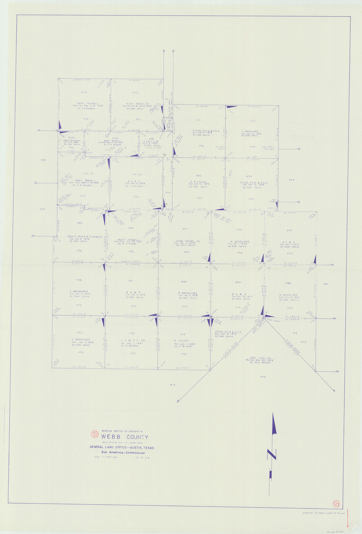
Webb County Working Sketch 73
-
Map/Doc
72440
-
Collection
General Map Collection
-
Object Dates
1/27/1975 (Creation Date)
-
People and Organizations
Elbert Menzel (Draftsman)
-
Counties
Webb
-
Subjects
Surveying Working Sketch
-
Height x Width
48.1 x 32.7 inches
122.2 x 83.1 cm
-
Scale
1" = 400 varas
Part of: General Map Collection
Flight Mission No. BQR-22K, Frame 47, Brazoria County

Print $20.00
- Digital $50.00
Flight Mission No. BQR-22K, Frame 47, Brazoria County
1953
Size 18.8 x 22.4 inches
Map/Doc 84131
[Beaumont, Sour Lake and Western Ry. Right of Way and Alignment - Frisco]
![64126, [Beaumont, Sour Lake and Western Ry. Right of Way and Alignment - Frisco], General Map Collection](https://historictexasmaps.com/wmedia_w700/maps/64126.tif.jpg)
Print $20.00
- Digital $50.00
[Beaumont, Sour Lake and Western Ry. Right of Way and Alignment - Frisco]
1910
Size 20.1 x 46.1 inches
Map/Doc 64126
Intracoastal Waterway in Texas - Corpus Christi to Point Isabel including Arroyo Colorado to Mo. Pac. R.R. Bridge Near Harlingen

Print $20.00
- Digital $50.00
Intracoastal Waterway in Texas - Corpus Christi to Point Isabel including Arroyo Colorado to Mo. Pac. R.R. Bridge Near Harlingen
1934
Size 21.8 x 32.6 inches
Map/Doc 61888
Webb County Rolled Sketch D

Print $20.00
- Digital $50.00
Webb County Rolled Sketch D
1897
Size 25.4 x 40.6 inches
Map/Doc 8222
Kent County Rolled Sketch 3

Print $20.00
- Digital $50.00
Kent County Rolled Sketch 3
1950
Size 27.6 x 25.3 inches
Map/Doc 6474
Hidalgo County Rolled Sketch 17

Print $40.00
- Digital $50.00
Hidalgo County Rolled Sketch 17
1963
Size 68.4 x 42.9 inches
Map/Doc 9172
Brewster County Working Sketch 89

Print $20.00
- Digital $50.00
Brewster County Working Sketch 89
1974
Size 20.5 x 44.1 inches
Map/Doc 67689
Hays County Sketch File 27

Print $6.00
- Digital $50.00
Hays County Sketch File 27
Size 11.2 x 8.8 inches
Map/Doc 26252
Callahan County Sketch File 11

Print $64.00
- Digital $50.00
Callahan County Sketch File 11
Size 11.4 x 8.4 inches
Map/Doc 35887
Wise County Sketch File 51

Print $2.00
- Digital $50.00
Wise County Sketch File 51
Size 8.5 x 3.9 inches
Map/Doc 40618
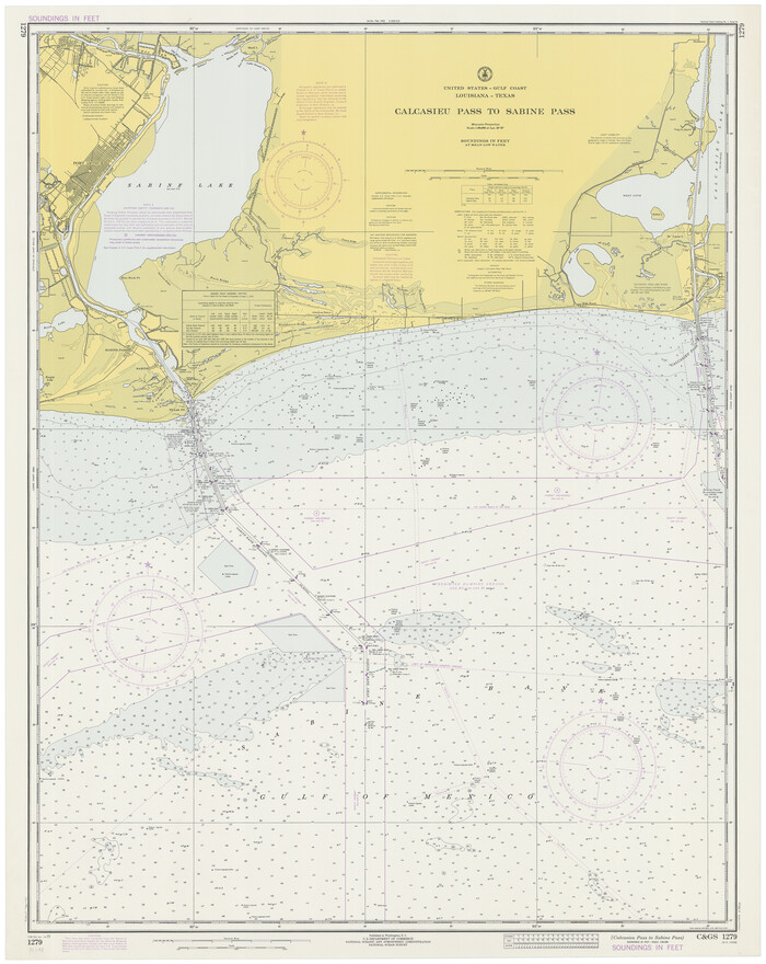
Calcasieu Pass to Sabine Pass
Print $20.00
- Digital $50.00
Calcasieu Pass to Sabine Pass
1973
Size 44.8 x 35.6 inches
Map/Doc 69812
Live Oak County Sketch File 30

Print $6.00
- Digital $50.00
Live Oak County Sketch File 30
1925
Size 14.1 x 8.8 inches
Map/Doc 30322
You may also like
Loving County, Texas

Print $20.00
- Digital $50.00
Loving County, Texas
1889
Size 18.8 x 23.8 inches
Map/Doc 638
Flight Mission No. BRA-9M, Frame 62, Jefferson County

Print $20.00
- Digital $50.00
Flight Mission No. BRA-9M, Frame 62, Jefferson County
1953
Size 18.7 x 22.3 inches
Map/Doc 85645
[Texas Gulf Coast]
![72678, [Texas Gulf Coast], General Map Collection](https://historictexasmaps.com/wmedia_w700/maps/72678.tif.jpg)
Print $20.00
- Digital $50.00
[Texas Gulf Coast]
Size 18.3 x 27.6 inches
Map/Doc 72678
Flight Mission No. DIX-10P, Frame 147, Aransas County

Print $20.00
- Digital $50.00
Flight Mission No. DIX-10P, Frame 147, Aransas County
1956
Size 18.7 x 22.4 inches
Map/Doc 83949
San Patricio County NRC Article 33.136 Sketch 1

Print $32.00
- Digital $50.00
San Patricio County NRC Article 33.136 Sketch 1
2001
Size 18.5 x 24.1 inches
Map/Doc 61623
Cottle County Working Sketch 1

Print $20.00
- Digital $50.00
Cottle County Working Sketch 1
1895
Size 27.0 x 21.7 inches
Map/Doc 68311
Matagorda County Rolled Sketch 35

Print $20.00
- Digital $50.00
Matagorda County Rolled Sketch 35
1903
Size 18.6 x 38.0 inches
Map/Doc 6696
Culberson County Working Sketch 23

Print $20.00
- Digital $50.00
Culberson County Working Sketch 23
1945
Size 38.3 x 44.7 inches
Map/Doc 68476
Right of Way & Track Map, St. Louis, Brownsville & Mexico Ry. operated by St. Louis, Brownsville & Mexico Ry. Co.

Print $40.00
- Digital $50.00
Right of Way & Track Map, St. Louis, Brownsville & Mexico Ry. operated by St. Louis, Brownsville & Mexico Ry. Co.
1919
Size 25.5 x 57.3 inches
Map/Doc 64622

Chambers County NRC Article 33.136 Sketch 11

Print $28.00
- Digital $50.00
Chambers County NRC Article 33.136 Sketch 11
2014
Size 24.0 x 36.0 inches
Map/Doc 94740
Chambers County Working Sketch 13

Print $20.00
- Digital $50.00
Chambers County Working Sketch 13
1956
Size 30.1 x 24.6 inches
Map/Doc 67996