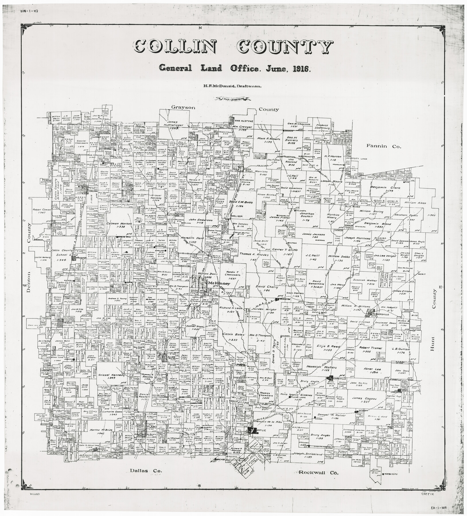
Collin County
RM-1-43
-
Map/Doc
1804
-
Collection
General Map Collection
-
Object Dates
1916 (Creation Date)
-
People and Organizations
Texas General Land Office (Publisher)
H.F. McDonald (Compiler)
H.F. McDonald (Draftsman)
-
Counties
Collin
-
Subjects
County
-
Height x Width
42.6 x 38.6 inches
108.2 x 98.0 cm
-
Comments
Traced in June 1916.
Part of: General Map Collection
Outer Continental Shelf Leasing Maps (Texas Offshore Operations)

Print $20.00
- Digital $50.00
Outer Continental Shelf Leasing Maps (Texas Offshore Operations)
1954
Size 20.3 x 15.5 inches
Map/Doc 75839
Somervell County Rolled Sketch A

Print $20.00
- Digital $50.00
Somervell County Rolled Sketch A
Size 14.8 x 15.2 inches
Map/Doc 75999
Wheeler County Working Sketch 2

Print $40.00
- Digital $50.00
Wheeler County Working Sketch 2
1957
Size 35.2 x 58.5 inches
Map/Doc 72491
Terrell County Working Sketch 54

Print $20.00
- Digital $50.00
Terrell County Working Sketch 54
1959
Size 25.2 x 42.9 inches
Map/Doc 62147
Briscoe County Working Sketch Graphic Index

Print $20.00
- Digital $50.00
Briscoe County Working Sketch Graphic Index
1930
Size 43.8 x 37.4 inches
Map/Doc 76478
Jasper County Rolled Sketch 3

Print $20.00
- Digital $50.00
Jasper County Rolled Sketch 3
1944
Size 24.5 x 43.4 inches
Map/Doc 6350
Flight Mission No. BRE-2P, Frame 123, Nueces County

Print $20.00
- Digital $50.00
Flight Mission No. BRE-2P, Frame 123, Nueces County
1956
Size 18.5 x 22.4 inches
Map/Doc 86799
Flight Mission No. CLL-1N, Frame 9, Willacy County

Print $20.00
- Digital $50.00
Flight Mission No. CLL-1N, Frame 9, Willacy County
1954
Size 18.4 x 22.1 inches
Map/Doc 86996
Brewster County Rolled Sketch 100

Print $133.00
- Digital $50.00
Brewster County Rolled Sketch 100
1893
Size 10.1 x 15.4 inches
Map/Doc 43055
Aransas County Rolled Sketch 15A

Print $20.00
- Digital $50.00
Aransas County Rolled Sketch 15A
1969
Size 26.3 x 25.4 inches
Map/Doc 8411
Starr County Rolled Sketch 12

Print $20.00
- Digital $50.00
Starr County Rolled Sketch 12
1912
Size 19.5 x 15.5 inches
Map/Doc 7799
Duval County Working Sketch 57

Print $20.00
- Digital $50.00
Duval County Working Sketch 57
1990
Size 30.3 x 25.4 inches
Map/Doc 68781
You may also like

Flight Mission No. BRA-16M, Frame 62, Jefferson County

Print $20.00
- Digital $50.00
Flight Mission No. BRA-16M, Frame 62, Jefferson County
1953
Size 18.7 x 22.4 inches
Map/Doc 85679
Matagorda County Rolled Sketch 12

Print $20.00
- Digital $50.00
Matagorda County Rolled Sketch 12
Size 30.0 x 28.0 inches
Map/Doc 6681
Comanche County

Print $20.00
- Digital $50.00
Comanche County
1896
Size 39.4 x 44.2 inches
Map/Doc 4734
Jones County Working Sketch 8

Print $20.00
- Digital $50.00
Jones County Working Sketch 8
1979
Size 25.3 x 20.9 inches
Map/Doc 66646
[Leagues 27, 28, 69, 70, 71, 72, and 73]
![91097, [Leagues 27, 28, 69, 70, 71, 72, and 73], Twichell Survey Records](https://historictexasmaps.com/wmedia_w700/maps/91097-1.tif.jpg)
Print $20.00
- Digital $50.00
[Leagues 27, 28, 69, 70, 71, 72, and 73]
Size 23.8 x 16.3 inches
Map/Doc 91097
Coryell County Sketch File 13

Print $4.00
- Digital $50.00
Coryell County Sketch File 13
1872
Size 5.0 x 8.5 inches
Map/Doc 19366
Runnels County Working Sketch 30a

Print $20.00
- Digital $50.00
Runnels County Working Sketch 30a
1959
Size 23.3 x 25.4 inches
Map/Doc 63626
Hardeman County Rolled Sketch 20

Print $40.00
- Digital $50.00
Hardeman County Rolled Sketch 20
Size 32.3 x 60.8 inches
Map/Doc 9102
Grayson County

Print $20.00
- Digital $50.00
Grayson County
1885
Size 39.9 x 35.8 inches
Map/Doc 16840
Bell County Rolled Sketch 1

Print $20.00
- Digital $50.00
Bell County Rolled Sketch 1
1954
Size 39.7 x 43.2 inches
Map/Doc 8445
Wise County Sketch File A

Print $8.00
- Digital $50.00
Wise County Sketch File A
1884
Size 9.1 x 8.1 inches
Map/Doc 40609