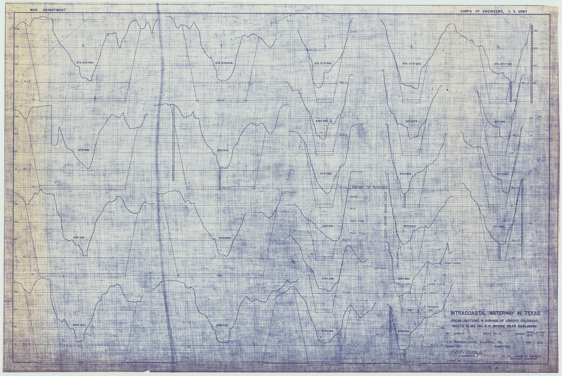
Intracoastal Waterway in Texas - Corpus Christi to Point Isabel including Arroyo Colorado to Mo. Pac. R.R. Bridge Near Harlingen
-
Map/Doc
61888
-
Collection
General Map Collection
-
Object Dates
1934 (Creation Date)
-
Subjects
Intracoastal Waterways
-
Height x Width
21.8 x 32.6 inches
55.4 x 82.8 cm
Part of: General Map Collection
Galveston County NRC Article 33.136 Location Key Sheet
![77024, Galveston County NRC Article 33.136 Location Key Sheet, General Map Collection](https://historictexasmaps.com/wmedia_w700/maps/77024.tif.jpg)
Print $20.00
- Digital $50.00
Galveston County NRC Article 33.136 Location Key Sheet
1994
Size 27.0 x 21.8 inches
Map/Doc 77024
Montague County Rolled Sketch R
![6794, Montague County Rolled Sketch R, General Map Collection](https://historictexasmaps.com/wmedia_w700/maps/6794.tif.jpg)
Print $20.00
- Digital $50.00
Montague County Rolled Sketch R
Size 44.3 x 29.8 inches
Map/Doc 6794
Duval County Sketch File 29
![21336, Duval County Sketch File 29, General Map Collection](https://historictexasmaps.com/wmedia_w700/pdf_converted_jpg/qi_pdf_thumbnail_10856.jpg)
Print $6.00
- Digital $50.00
Duval County Sketch File 29
1932
Size 14.6 x 8.8 inches
Map/Doc 21336
Starr County Working Sketch 17
![63933, Starr County Working Sketch 17, General Map Collection](https://historictexasmaps.com/wmedia_w700/maps/63933.tif.jpg)
Print $20.00
- Digital $50.00
Starr County Working Sketch 17
Size 46.1 x 42.7 inches
Map/Doc 63933
Archer County Working Sketch 9
![67149, Archer County Working Sketch 9, General Map Collection](https://historictexasmaps.com/wmedia_w700/maps/67149.tif.jpg)
Print $20.00
- Digital $50.00
Archer County Working Sketch 9
1924
Size 22.2 x 29.8 inches
Map/Doc 67149
Crockett County Sketch File 93
![19946, Crockett County Sketch File 93, General Map Collection](https://historictexasmaps.com/wmedia_w700/pdf_converted_jpg/qi_pdf_thumbnail_10523.jpg)
Print $8.00
- Digital $50.00
Crockett County Sketch File 93
1887
Size 12.7 x 8.2 inches
Map/Doc 19946
Eastland County Working Sketch 51
![68832, Eastland County Working Sketch 51, General Map Collection](https://historictexasmaps.com/wmedia_w700/maps/68832.tif.jpg)
Print $20.00
- Digital $50.00
Eastland County Working Sketch 51
Size 37.7 x 39.6 inches
Map/Doc 68832
Atascosa County Working Sketch 25
![67221, Atascosa County Working Sketch 25, General Map Collection](https://historictexasmaps.com/wmedia_w700/maps/67221.tif.jpg)
Print $20.00
- Digital $50.00
Atascosa County Working Sketch 25
1958
Size 38.2 x 44.0 inches
Map/Doc 67221
Nacogdoches County Sketch File 10
![32253, Nacogdoches County Sketch File 10, General Map Collection](https://historictexasmaps.com/wmedia_w700/pdf_converted_jpg/qi_pdf_thumbnail_13249.jpg)
Print $6.00
- Digital $50.00
Nacogdoches County Sketch File 10
1886
Size 12.9 x 11.0 inches
Map/Doc 32253
Right of Way and Track Map Texas & New Orleans R.R. Co. operated by the T. & N. O. R.R. Co. Dallas-Sabine Branch
![64150, Right of Way and Track Map Texas & New Orleans R.R. Co. operated by the T. & N. O. R.R. Co. Dallas-Sabine Branch, General Map Collection](https://historictexasmaps.com/wmedia_w700/maps/64150.tif.jpg)
Print $40.00
- Digital $50.00
Right of Way and Track Map Texas & New Orleans R.R. Co. operated by the T. & N. O. R.R. Co. Dallas-Sabine Branch
1918
Size 26.1 x 56.7 inches
Map/Doc 64150
Castro County Rolled Sketch 14
![8608, Castro County Rolled Sketch 14, General Map Collection](https://historictexasmaps.com/wmedia_w700/maps/8608.tif.jpg)
Print $20.00
- Digital $50.00
Castro County Rolled Sketch 14
1965
Size 47.6 x 43.5 inches
Map/Doc 8608
DeWitt County Working Sketch 11
![68601, DeWitt County Working Sketch 11, General Map Collection](https://historictexasmaps.com/wmedia_w700/maps/68601.tif.jpg)
Print $20.00
- Digital $50.00
DeWitt County Working Sketch 11
Size 15.9 x 12.8 inches
Map/Doc 68601
You may also like
Map of Portion of the Gulf of Mexico Adjoining Jefferson County Showing Subdivision Thereof for Mineral Development
![3020, Map of Portion of the Gulf of Mexico Adjoining Jefferson County Showing Subdivision Thereof for Mineral Development, General Map Collection](https://historictexasmaps.com/wmedia_w700/maps/3020.tif.jpg)
Print $20.00
- Digital $50.00
Map of Portion of the Gulf of Mexico Adjoining Jefferson County Showing Subdivision Thereof for Mineral Development
1937
Size 20.5 x 39.0 inches
Map/Doc 3020
Geological Map of the route explored by Capt. Jno. Pope, Corps of Topl. Engrs. near the 32nd Parallel of North Latitude from the Red River to the Rio Grande
![95751, Geological Map of the route explored by Capt. Jno. Pope, Corps of Topl. Engrs. near the 32nd Parallel of North Latitude from the Red River to the Rio Grande, Cobb Digital Map Collection](https://historictexasmaps.com/wmedia_w700/maps/95751.tif.jpg)
Print $20.00
- Digital $50.00
Geological Map of the route explored by Capt. Jno. Pope, Corps of Topl. Engrs. near the 32nd Parallel of North Latitude from the Red River to the Rio Grande
1854
Size 11.1 x 24.8 inches
Map/Doc 95751
[Sketch showing surveys in the south half of Potter County, Blocks 6, 20-E, JAD, M-3, S, B. S. & F. Blocks 1 and 9, and A. B. and M. Block 2]
![91741, [Sketch showing surveys in the south half of Potter County, Blocks 6, 20-E, JAD, M-3, S, B. S. & F. Blocks 1 and 9, and A. B. and M. Block 2], Twichell Survey Records](https://historictexasmaps.com/wmedia_w700/maps/91741-1.tif.jpg)
Print $20.00
- Digital $50.00
[Sketch showing surveys in the south half of Potter County, Blocks 6, 20-E, JAD, M-3, S, B. S. & F. Blocks 1 and 9, and A. B. and M. Block 2]
Size 40.5 x 18.1 inches
Map/Doc 91741
Flight Mission No. DAG-19K, Frame 62, Matagorda County
![86389, Flight Mission No. DAG-19K, Frame 62, Matagorda County, General Map Collection](https://historictexasmaps.com/wmedia_w700/pdf_converted_jpg/qi_pdf_thumbnail_33533.jpg)
Print $20.00
- Digital $50.00
Flight Mission No. DAG-19K, Frame 62, Matagorda County
1952
Size 16.2 x 16.1 inches
Map/Doc 86389
Trinity County Sketch File 30
![38566, Trinity County Sketch File 30, General Map Collection](https://historictexasmaps.com/wmedia_w700/pdf_converted_jpg/qi_pdf_thumbnail_14640.jpg)
Print $8.00
- Digital $50.00
Trinity County Sketch File 30
1891
Size 14.2 x 8.9 inches
Map/Doc 38566
Kinney County Working Sketch 29
![70211, Kinney County Working Sketch 29, General Map Collection](https://historictexasmaps.com/wmedia_w700/maps/70211-1.tif.jpg)
Print $20.00
- Digital $50.00
Kinney County Working Sketch 29
Size 37.8 x 33.8 inches
Map/Doc 70211
English Field Notes of the Spanish Archives - Book D
![96542, English Field Notes of the Spanish Archives - Book D, Historical Volumes](https://historictexasmaps.com/wmedia_w700/pdf_converted_jpg/qi_pdf_thumbnail_40537.jpg)
English Field Notes of the Spanish Archives - Book D
1835
Map/Doc 96542
Eastland County Working Sketch 46
![68827, Eastland County Working Sketch 46, General Map Collection](https://historictexasmaps.com/wmedia_w700/maps/68827.tif.jpg)
Print $20.00
- Digital $50.00
Eastland County Working Sketch 46
Size 33.4 x 36.6 inches
Map/Doc 68827
Reeves County Working Sketch 43
![63486, Reeves County Working Sketch 43, General Map Collection](https://historictexasmaps.com/wmedia_w700/maps/63486.tif.jpg)
Print $20.00
- Digital $50.00
Reeves County Working Sketch 43
Size 43.2 x 37.1 inches
Map/Doc 63486
Newton County Sketch File 48
![32460, Newton County Sketch File 48, General Map Collection](https://historictexasmaps.com/wmedia_w700/pdf_converted_jpg/qi_pdf_thumbnail_13317.jpg)
Print $4.00
- Digital $50.00
Newton County Sketch File 48
Size 12.4 x 7.9 inches
Map/Doc 32460
[Sketch around Falls County School Land and surveys to South]
![91886, [Sketch around Falls County School Land and surveys to South], Twichell Survey Records](https://historictexasmaps.com/wmedia_w700/maps/91886-1.tif.jpg)
Print $20.00
- Digital $50.00
[Sketch around Falls County School Land and surveys to South]
1894
Size 13.1 x 12.1 inches
Map/Doc 91886