Pecos County Rolled Sketch 27
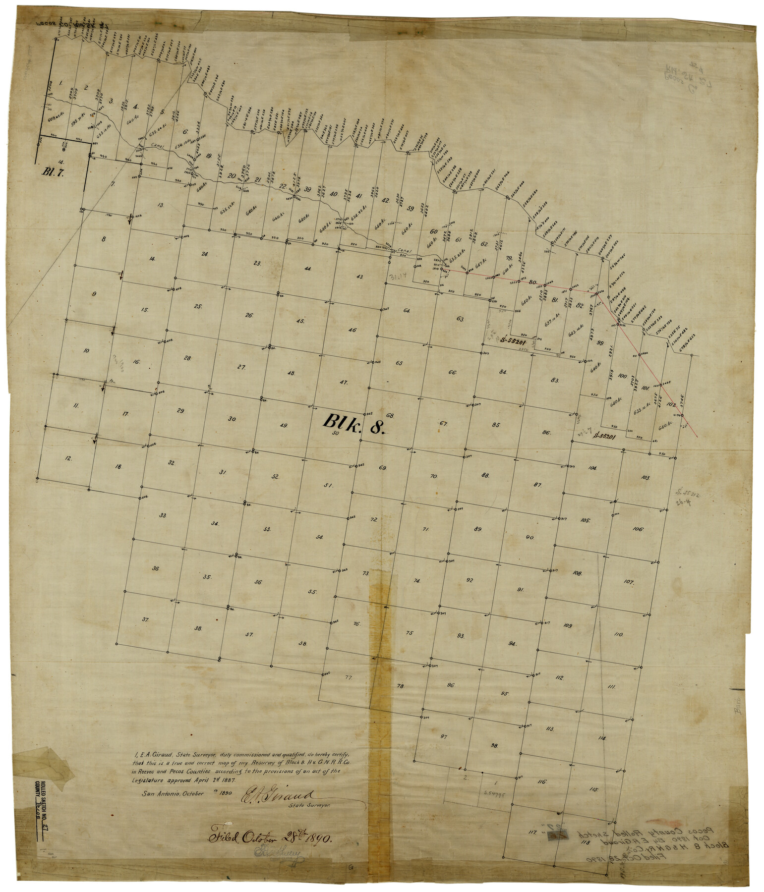
[Sketch of a resurvey of Block 8, H. & G. N. R.R. Co. in Reeves in Pecos Counties]
-
Map/Doc
7212
-
Collection
General Map Collection
-
Object Dates
10/1890 (Creation Date)
10/28/1890 (File Date)
-
People and Organizations
E.A. Giraud (Surveyor/Engineer)
-
Counties
Pecos Reeves
-
Subjects
Surveying Rolled Sketch
-
Height x Width
32.3 x 28.3 inches
82.0 x 71.9 cm
-
Medium
linen, manuscript
Part of: General Map Collection
San Jacinto County Working Sketch 27

Print $20.00
- Digital $50.00
San Jacinto County Working Sketch 27
1944
Size 30.5 x 23.3 inches
Map/Doc 63740
Supplemental Plat of T. 5S., R. 14W., Indian Meridian, Oklahoma

Print $4.00
- Digital $50.00
Supplemental Plat of T. 5S., R. 14W., Indian Meridian, Oklahoma
1924
Size 18.6 x 24.2 inches
Map/Doc 75139
Ellis County Sketch File 3

Print $20.00
- Digital $50.00
Ellis County Sketch File 3
Size 23.6 x 28.0 inches
Map/Doc 11462
Montgomery County Rolled Sketch 32

Print $40.00
- Digital $50.00
Montgomery County Rolled Sketch 32
1949
Size 59.9 x 40.4 inches
Map/Doc 9540
Flight Mission No. CGI-2N, Frame 187, Cameron County

Print $20.00
- Digital $50.00
Flight Mission No. CGI-2N, Frame 187, Cameron County
1954
Size 18.5 x 22.2 inches
Map/Doc 84547
[FT. W. & R. G. Ry. Right of Way Map, Winchell to Brady, McCulloch County, Texas]
![61411, [FT. W. & R. G. Ry. Right of Way Map, Winchell to Brady, McCulloch County, Texas], General Map Collection](https://historictexasmaps.com/wmedia_w700/maps/61411.tif.jpg)
Print $20.00
- Digital $50.00
[FT. W. & R. G. Ry. Right of Way Map, Winchell to Brady, McCulloch County, Texas]
1918
Size 37.0 x 26.9 inches
Map/Doc 61411
Flight Mission No. BRA-7M, Frame 31, Jefferson County

Print $20.00
- Digital $50.00
Flight Mission No. BRA-7M, Frame 31, Jefferson County
1953
Size 18.5 x 22.3 inches
Map/Doc 85482
La Salle County Sketch File 10

Print $4.00
- Digital $50.00
La Salle County Sketch File 10
1877
Size 9.0 x 7.0 inches
Map/Doc 42997
Freestone County Sketch File 22

Print $40.00
- Digital $50.00
Freestone County Sketch File 22
1886
Size 14.4 x 17.3 inches
Map/Doc 23082
Navarro County Working Sketch 1a

Print $20.00
- Digital $50.00
Navarro County Working Sketch 1a
1888
Size 32.5 x 44.6 inches
Map/Doc 71229
Houston County Sketch File 18

Print $4.00
- Digital $50.00
Houston County Sketch File 18
Size 4.8 x 10.3 inches
Map/Doc 26781
Wise County Boundary File 96

Print $50.00
- Digital $50.00
Wise County Boundary File 96
Size 9.2 x 3.8 inches
Map/Doc 60130
You may also like
Reagan County

Print $20.00
- Digital $50.00
Reagan County
1940
Size 41.6 x 31.4 inches
Map/Doc 77403
Reagan County Working Sketch 49

Print $20.00
- Digital $50.00
Reagan County Working Sketch 49
1990
Size 40.4 x 25.2 inches
Map/Doc 71892
Brewster County Sketch File S-1

Print $10.00
- Digital $50.00
Brewster County Sketch File S-1
1921
Size 13.3 x 8.8 inches
Map/Doc 15726
[Block AX and vicinity]
![90860, [Block AX and vicinity], Twichell Survey Records](https://historictexasmaps.com/wmedia_w700/maps/90860-2.tif.jpg)
Print $20.00
- Digital $50.00
[Block AX and vicinity]
Size 35.9 x 19.7 inches
Map/Doc 90860
Gaines County Working Sketch 13

Print $20.00
- Digital $50.00
Gaines County Working Sketch 13
1954
Size 36.8 x 39.4 inches
Map/Doc 69313
[FT. W. & R. G. Ry. Right of Way Map, Winchell to Brady, McCulloch County, Texas]
![61415, [FT. W. & R. G. Ry. Right of Way Map, Winchell to Brady, McCulloch County, Texas], General Map Collection](https://historictexasmaps.com/wmedia_w700/maps/61415.tif.jpg)
Print $40.00
- Digital $50.00
[FT. W. & R. G. Ry. Right of Way Map, Winchell to Brady, McCulloch County, Texas]
1918
Size 38.2 x 122.0 inches
Map/Doc 61415
Cherokee County Boundary File 6 and 15

Print $8.00
- Digital $50.00
Cherokee County Boundary File 6 and 15
Size 8.3 x 6.7 inches
Map/Doc 51301
[Surveys in Austin's Colony at Matagorda Bay and along the Trespalacios and Colorado Rivers]
![147, [Surveys in Austin's Colony at Matagorda Bay and along the Trespalacios and Colorado Rivers], General Map Collection](https://historictexasmaps.com/wmedia_w700/maps/147.tif.jpg)
Print $20.00
- Digital $50.00
[Surveys in Austin's Colony at Matagorda Bay and along the Trespalacios and Colorado Rivers]
1821
Size 31.6 x 20.5 inches
Map/Doc 147
[T. & P. Blocks 31-33, Township 5N]
![90568, [T. & P. Blocks 31-33, Township 5N], Twichell Survey Records](https://historictexasmaps.com/wmedia_w700/maps/90568-1.tif.jpg)
Print $20.00
- Digital $50.00
[T. & P. Blocks 31-33, Township 5N]
Size 14.6 x 17.7 inches
Map/Doc 90568
Howard County Working Sketch 13

Print $20.00
- Digital $50.00
Howard County Working Sketch 13
1983
Size 33.3 x 37.3 inches
Map/Doc 66281
Calhoun County Sketch File 14

Print $20.00
- Digital $50.00
Calhoun County Sketch File 14
1852
Size 22.6 x 16.2 inches
Map/Doc 35980
Dawson County Working Sketch 4

Print $20.00
- Digital $50.00
Dawson County Working Sketch 4
1926
Size 32.2 x 23.8 inches
Map/Doc 68549