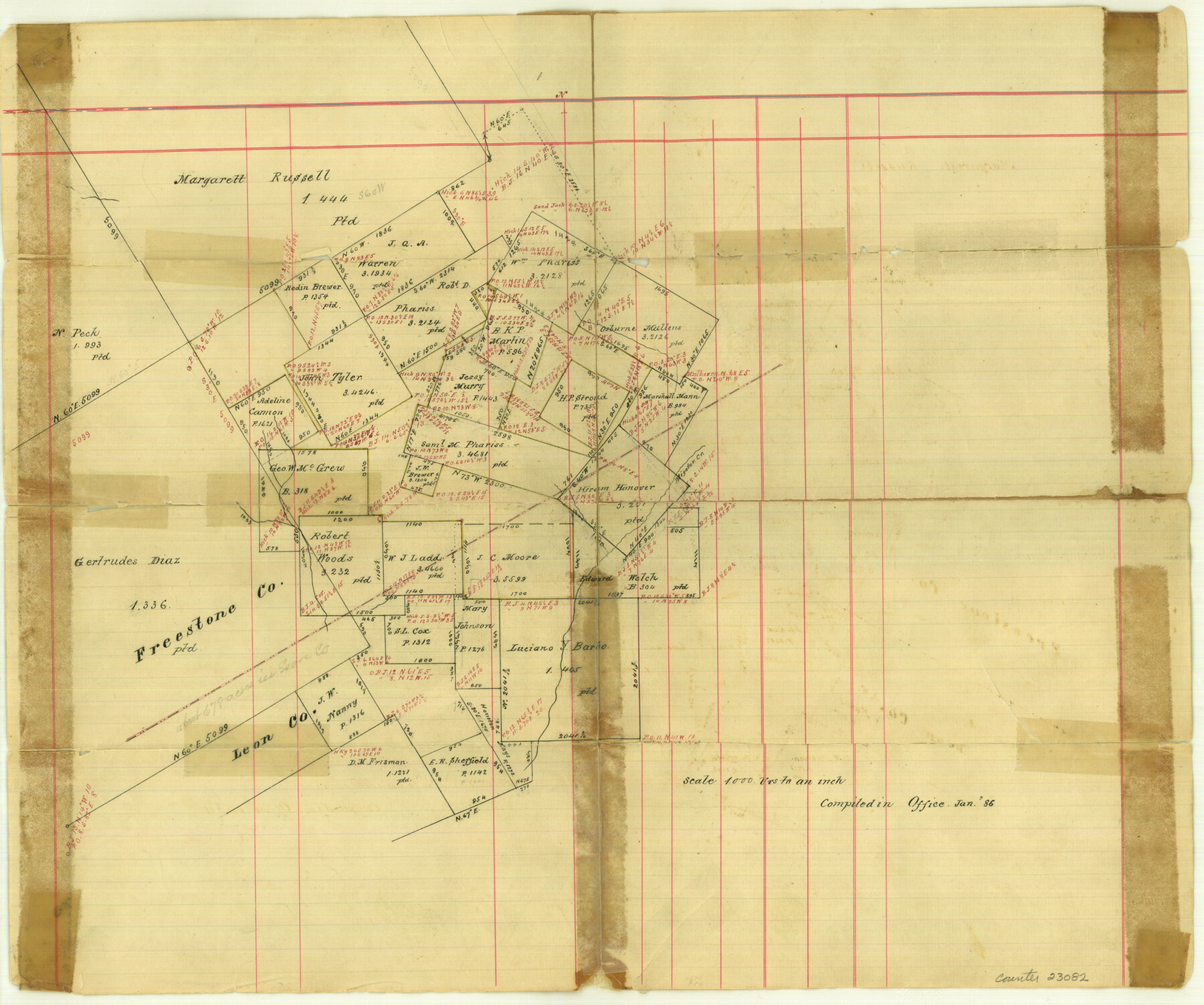
Freestone County Sketch File 22
[Sketch of surveys along Freestone-Leon County line]
-
Map/Doc
23082
-
Collection
General Map Collection
-
Object Dates
1886 (File Date)
1886 (Creation Date)
-
People and Organizations
Pressler (Surveyor/Engineer)
-
Counties
Freestone Leon
-
Subjects
Surveying Sketch File
-
Height x Width
14.4 x 17.3 inches
36.6 x 43.9 cm
-
Medium
paper, manuscript
-
Scale
1" = 1000 varas
-
Features
Aligator [sic] Creek
Part of: General Map Collection
Henderson County Working Sketch 37

Print $20.00
- Digital $50.00
Henderson County Working Sketch 37
1982
Size 29.4 x 22.0 inches
Map/Doc 66170
Lavaca County Rolled Sketch 2

Print $20.00
- Digital $50.00
Lavaca County Rolled Sketch 2
1951
Size 37.0 x 26.7 inches
Map/Doc 6592
Zavala County Rolled Sketch 31

Print $20.00
- Digital $50.00
Zavala County Rolled Sketch 31
1883
Size 37.4 x 27.1 inches
Map/Doc 8332
Ellis County Sketch File 22

Print $2.00
- Digital $50.00
Ellis County Sketch File 22
1857
Size 8.0 x 4.0 inches
Map/Doc 88797
Crockett County Working Sketch Graphic Index - northwest part - sheet B

Print $20.00
- Digital $50.00
Crockett County Working Sketch Graphic Index - northwest part - sheet B
1983
Size 36.2 x 47.7 inches
Map/Doc 76510
Flight Mission No. DAG-24K, Frame 159, Matagorda County

Print $20.00
- Digital $50.00
Flight Mission No. DAG-24K, Frame 159, Matagorda County
1953
Size 17.2 x 19.1 inches
Map/Doc 86573
Padre Island National Seashore

Print $2.00
- Digital $50.00
Padre Island National Seashore
Size 11.2 x 8.2 inches
Map/Doc 60524
Tarrant County Sketch File 36

Print $56.00
- Digital $50.00
Tarrant County Sketch File 36
2018
Size 11.0 x 8.5 inches
Map/Doc 95395
Kaufman County Working Sketch 5

Print $20.00
- Digital $50.00
Kaufman County Working Sketch 5
1922
Size 31.8 x 46.0 inches
Map/Doc 66668
Starr County Rolled Sketch 43

Print $20.00
- Digital $50.00
Starr County Rolled Sketch 43
1982
Size 36.1 x 30.9 inches
Map/Doc 7836
Callahan County Working Sketch 14

Print $20.00
- Digital $50.00
Callahan County Working Sketch 14
2010
Size 25.8 x 23.7 inches
Map/Doc 89273

You may also like
Roberts County Working Sketch 16

Print $20.00
- Digital $50.00
Roberts County Working Sketch 16
1975
Size 37.1 x 39.8 inches
Map/Doc 63542
Flight Mission No. DIX-8P, Frame 74, Aransas County

Print $20.00
- Digital $50.00
Flight Mission No. DIX-8P, Frame 74, Aransas County
1956
Size 18.7 x 22.5 inches
Map/Doc 83905

Map of Chicago, Rock Island & Texas Railway through Tarrant County, Texas

Print $20.00
- Digital $50.00
Map of Chicago, Rock Island & Texas Railway through Tarrant County, Texas
1893
Size 20.7 x 35.7 inches
Map/Doc 64414
Burleson County Working Sketch 8

Print $20.00
- Digital $50.00
Burleson County Working Sketch 8
1980
Size 29.3 x 23.2 inches
Map/Doc 67727
Clay County Sketch File 2

Print $4.00
- Digital $50.00
Clay County Sketch File 2
Size 8.3 x 6.7 inches
Map/Doc 18389
Garza County Rolled Sketch 16

Print $20.00
- Digital $50.00
Garza County Rolled Sketch 16
Size 30.5 x 32.3 inches
Map/Doc 9048
Working Sketch in Garza County [J. Hays Block 1]
![90920, Working Sketch in Garza County [J. Hays Block 1], Twichell Survey Records](https://historictexasmaps.com/wmedia_w700/maps/90920-1.tif.jpg)
Print $2.00
- Digital $50.00
Working Sketch in Garza County [J. Hays Block 1]
1903
Size 9.1 x 12.4 inches
Map/Doc 90920
Leon River, Leon River Sheet No. 1

Print $4.00
- Digital $50.00
Leon River, Leon River Sheet No. 1
1936
Size 29.2 x 19.8 inches
Map/Doc 65067
[Coastal Chart of Galveston Island, Bolivar Peninsula and Galveston Bay]
![61804, [Coastal Chart of Galveston Island, Bolivar Peninsula and Galveston Bay], General Map Collection](https://historictexasmaps.com/wmedia_w700/maps/61804.tif.jpg)
Print $20.00
- Digital $50.00
[Coastal Chart of Galveston Island, Bolivar Peninsula and Galveston Bay]
Size 24.0 x 18.1 inches
Map/Doc 61804
Somervell County Sketch File 7

Print $8.00
- Digital $50.00
Somervell County Sketch File 7
1987
Size 11.4 x 8.9 inches
Map/Doc 36850
Map of Upton County

Print $20.00
- Digital $50.00
Map of Upton County
1899
Size 47.3 x 41.1 inches
Map/Doc 16909