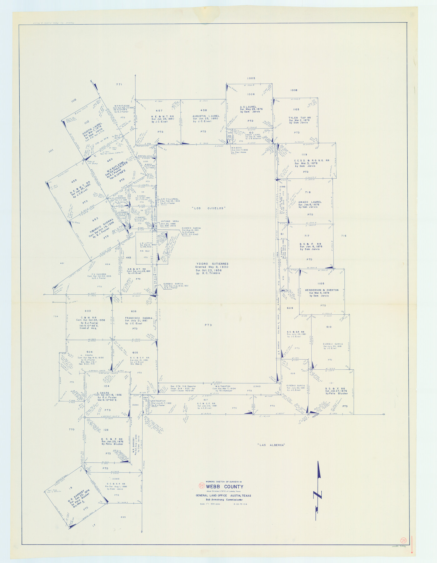
Webb County Working Sketch 75
-
Map/Doc
72442
-
Collection
General Map Collection
-
Object Dates
8/22/1975 (Creation Date)
-
People and Organizations
Elbert Menzel (Draftsman)
-
Counties
Webb
-
Subjects
Surveying Working Sketch
-
Height x Width
59.2 x 46.0 inches
150.4 x 116.8 cm
-
Scale
1" = 400 varas
Part of: General Map Collection
Flight Mission No. DQN-1K, Frame 143, Calhoun County

Print $20.00
- Digital $50.00
Flight Mission No. DQN-1K, Frame 143, Calhoun County
1953
Size 18.5 x 22.1 inches
Map/Doc 84206
Fort Bend County Sketch File 24

Print $20.00
- Digital $50.00
Fort Bend County Sketch File 24
1890
Size 23.5 x 32.4 inches
Map/Doc 11509
Collin County Sketch File 4

Print $4.00
- Digital $50.00
Collin County Sketch File 4
1856
Size 10.0 x 8.0 inches
Map/Doc 18862
Pecos County Rolled Sketch 50

Print $20.00
- Digital $50.00
Pecos County Rolled Sketch 50
1913
Size 23.5 x 13.0 inches
Map/Doc 7226
Parker County Working Sketch 18

Print $20.00
- Digital $50.00
Parker County Working Sketch 18
2000
Map/Doc 71468
McMullen County Working Sketch 50

Print $20.00
- Digital $50.00
McMullen County Working Sketch 50
1983
Size 18.4 x 18.0 inches
Map/Doc 70751
Bosque County Sketch File 16

Print $14.00
- Digital $50.00
Bosque County Sketch File 16
Size 13.0 x 7.9 inches
Map/Doc 14781
Flight Mission No. DCL-6C, Frame 117, Kenedy County

Print $20.00
- Digital $50.00
Flight Mission No. DCL-6C, Frame 117, Kenedy County
1943
Size 18.5 x 22.2 inches
Map/Doc 85947
Dimmit County Sketch File 30

Print $4.00
- Digital $50.00
Dimmit County Sketch File 30
Size 10.6 x 8.5 inches
Map/Doc 21146
Crane County Rolled Sketch 20

Print $20.00
- Digital $50.00
Crane County Rolled Sketch 20
Size 44.5 x 34.6 inches
Map/Doc 8684
Hardin County Working Sketch 25

Print $20.00
- Digital $50.00
Hardin County Working Sketch 25
1950
Size 10.8 x 20.1 inches
Map/Doc 63423
Crane County Working Sketch 32

Print $20.00
- Digital $50.00
Crane County Working Sketch 32
1984
Size 37.6 x 43.1 inches
Map/Doc 68309
You may also like
Rusk County Rolled Sketch OBS

Print $20.00
- Digital $50.00
Rusk County Rolled Sketch OBS
1937
Size 26.3 x 21.8 inches
Map/Doc 7550
Zavalla County School Land Hockley County, Texas

Print $20.00
- Digital $50.00
Zavalla County School Land Hockley County, Texas
1956
Size 41.6 x 20.2 inches
Map/Doc 92254
Dawson County Sketch File 3

Print $20.00
- Digital $50.00
Dawson County Sketch File 3
Size 13.5 x 37.8 inches
Map/Doc 11290
Brewster County Rolled Sketch 26

Print $20.00
- Digital $50.00
Brewster County Rolled Sketch 26
Size 15.8 x 32.0 inches
Map/Doc 5214
Blanco County Sketch File 35

Print $6.00
- Digital $50.00
Blanco County Sketch File 35
1890
Size 6.3 x 7.0 inches
Map/Doc 14639
Hunt County Rolled Sketch 2

Print $20.00
- Digital $50.00
Hunt County Rolled Sketch 2
Size 31.8 x 29.9 inches
Map/Doc 9240
Reagan County Working Sketch 36

Print $20.00
- Digital $50.00
Reagan County Working Sketch 36
1966
Size 29.6 x 20.6 inches
Map/Doc 71878
Shamrock, Amended Plat on Section 44, Block 17, Wheeler County, Texas

Print $20.00
- Digital $50.00
Shamrock, Amended Plat on Section 44, Block 17, Wheeler County, Texas
Size 30.0 x 35.5 inches
Map/Doc 92144
Flight Mission No. DQN-1K, Frame 142, Calhoun County

Print $20.00
- Digital $50.00
Flight Mission No. DQN-1K, Frame 142, Calhoun County
1953
Size 18.8 x 22.3 inches
Map/Doc 84205
Map Showing Soash Lands in Castro, Lamb, and Hale Counties, Texas

Print $20.00
- Digital $50.00
Map Showing Soash Lands in Castro, Lamb, and Hale Counties, Texas
1907
Size 13.9 x 17.6 inches
Map/Doc 91000
Coryell County Working Sketch 32

Print $20.00
- Digital $50.00
Coryell County Working Sketch 32
2022
Size 25.3 x 36.9 inches
Map/Doc 96966
[North/South line through middle of Block K5]
![90600, [North/South line through middle of Block K5], Twichell Survey Records](https://historictexasmaps.com/wmedia_w700/maps/90600-1.tif.jpg)
Print $3.00
- Digital $50.00
[North/South line through middle of Block K5]
Size 6.8 x 16.9 inches
Map/Doc 90600