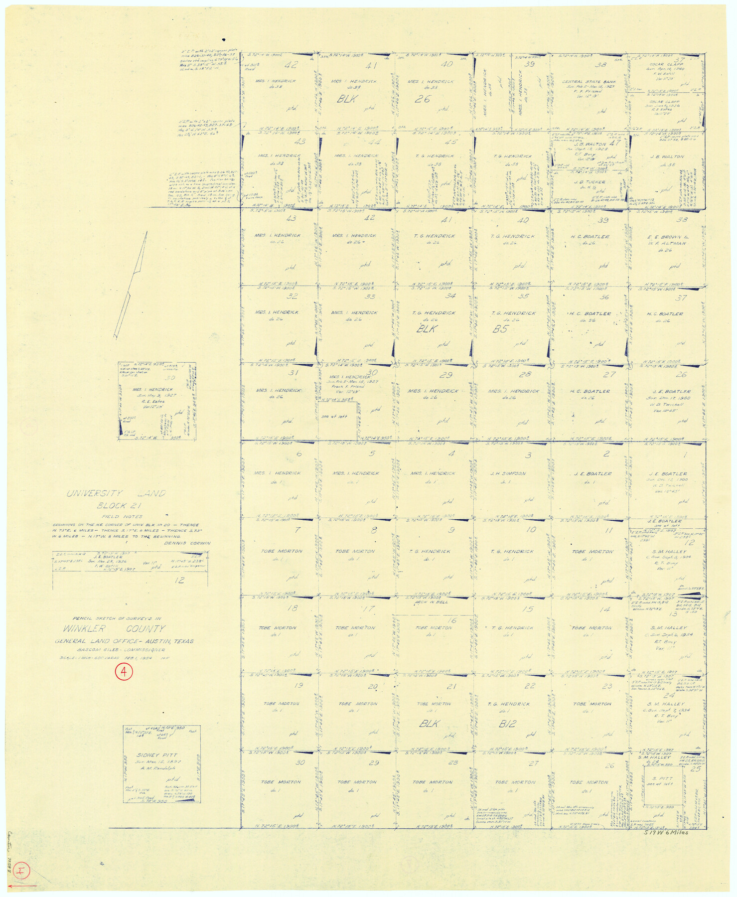
Winkler County Working Sketch 4
-
Map/Doc
72598
-
Collection
General Map Collection
-
Object Dates
2/1/1954 (Creation Date)
-
Counties
Winkler
-
Subjects
Surveying Working Sketch
-
Height x Width
36.7 x 30.1 inches
93.2 x 76.5 cm
-
Scale
1" = 600 varas
Part of: General Map Collection
[Geological Map of Texas]
![62962, [Geological Map of Texas], General Map Collection](https://historictexasmaps.com/wmedia_w700/maps/62962.tif.jpg)
Print $20.00
- Digital $50.00
[Geological Map of Texas]
Size 17.6 x 18.1 inches
Map/Doc 62962
Flight Mission No. CRC-5R, Frame 41, Chambers County

Print $20.00
- Digital $50.00
Flight Mission No. CRC-5R, Frame 41, Chambers County
1956
Size 18.7 x 22.3 inches
Map/Doc 84960
Hardin County Sketch File 37

Print $20.00
- Digital $50.00
Hardin County Sketch File 37
Size 20.4 x 17.7 inches
Map/Doc 11633
Fisher County Sketch File 17

Print $6.00
- Digital $50.00
Fisher County Sketch File 17
Size 11.0 x 12.5 inches
Map/Doc 22587
Haskell County Boundary File 1a

Print $40.00
- Digital $50.00
Haskell County Boundary File 1a
Size 34.9 x 38.3 inches
Map/Doc 54536
[Galveston, Harrisburg & San Antonio Railroad from Cuero to Stockdale]
![64204, [Galveston, Harrisburg & San Antonio Railroad from Cuero to Stockdale], General Map Collection](https://historictexasmaps.com/wmedia_w700/maps/64204.tif.jpg)
Print $20.00
- Digital $50.00
[Galveston, Harrisburg & San Antonio Railroad from Cuero to Stockdale]
1907
Size 13.3 x 33.1 inches
Map/Doc 64204
[The S.K. Ry. of Texas, State Line to Pecos, Reeves Co., Texas]
![64164, [The S.K. Ry. of Texas, State Line to Pecos, Reeves Co., Texas], General Map Collection](https://historictexasmaps.com/wmedia_w700/maps/64164-1.tif.jpg)
Print $40.00
- Digital $50.00
[The S.K. Ry. of Texas, State Line to Pecos, Reeves Co., Texas]
1910
Size 18.7 x 95.8 inches
Map/Doc 64164
Colorado County Sketch File 17

Print $22.00
- Digital $50.00
Colorado County Sketch File 17
Size 8.7 x 7.7 inches
Map/Doc 18949
Cottle County Sketch File KN

Print $20.00
- Digital $50.00
Cottle County Sketch File KN
Size 18.8 x 25.2 inches
Map/Doc 11203
Motley County Boundary File 1a

Print $8.00
- Digital $50.00
Motley County Boundary File 1a
Size 11.2 x 8.5 inches
Map/Doc 57501
Stonewall County Rolled Sketch 31

Print $20.00
- Digital $50.00
Stonewall County Rolled Sketch 31
1982
Size 25.6 x 42.9 inches
Map/Doc 7875
Map of Runnels County

Print $20.00
- Digital $50.00
Map of Runnels County
1887
Size 24.7 x 19.9 inches
Map/Doc 4000
You may also like
Hudspeth County Working Sketch 23

Print $40.00
- Digital $50.00
Hudspeth County Working Sketch 23
1967
Size 52.6 x 39.2 inches
Map/Doc 66305
Colorado County Sketch File 5

Print $4.00
- Digital $50.00
Colorado County Sketch File 5
Size 12.5 x 8.3 inches
Map/Doc 18919
Coke County Working Sketch 28

Print $20.00
- Digital $50.00
Coke County Working Sketch 28
1965
Size 32.7 x 42.2 inches
Map/Doc 68065
[Subdivision of Nueces Bay and list of Court Decrees]
![2086, [Subdivision of Nueces Bay and list of Court Decrees], General Map Collection](https://historictexasmaps.com/wmedia_w700/maps/2086-1.tif.jpg)
Print $40.00
- Digital $50.00
[Subdivision of Nueces Bay and list of Court Decrees]
1940
Size 34.2 x 48.8 inches
Map/Doc 2086
Galveston County Rolled Sketch CCW

Print $20.00
- Digital $50.00
Galveston County Rolled Sketch CCW
1938
Size 38.4 x 39.7 inches
Map/Doc 9084
[T. T. RR. Co. Block 8 and vicinity]
![90795, [T. T. RR. Co. Block 8 and vicinity], Twichell Survey Records](https://historictexasmaps.com/wmedia_w700/maps/90795-1.tif.jpg)
Print $20.00
- Digital $50.00
[T. T. RR. Co. Block 8 and vicinity]
Size 20.3 x 15.2 inches
Map/Doc 90795
Flight Mission No. BRE-2P, Frame 34, Nueces County

Print $20.00
- Digital $50.00
Flight Mission No. BRE-2P, Frame 34, Nueces County
1956
Size 18.7 x 22.6 inches
Map/Doc 86736
Bosque County Working Sketch 5

Print $20.00
- Digital $50.00
Bosque County Working Sketch 5
1935
Size 20.5 x 28.9 inches
Map/Doc 67438
Brazos Santiago & Boca Chica entrances, Texas

Print $20.00
- Digital $50.00
Brazos Santiago & Boca Chica entrances, Texas
1867
Size 18.1 x 25.6 inches
Map/Doc 72927
Blanco County Rolled Sketch 10

Print $20.00
- Digital $50.00
Blanco County Rolled Sketch 10
Size 28.0 x 25.6 inches
Map/Doc 5146
Maps & Lists Showing Prison Lands (Oil & Gas) Leased as of June 1955

Digital $50.00
Maps & Lists Showing Prison Lands (Oil & Gas) Leased as of June 1955
Size 11.1 x 8.8 inches
Map/Doc 62873
Yoakum County, Texas

Print $20.00
- Digital $50.00
Yoakum County, Texas
1936
Size 38.4 x 43.5 inches
Map/Doc 89903