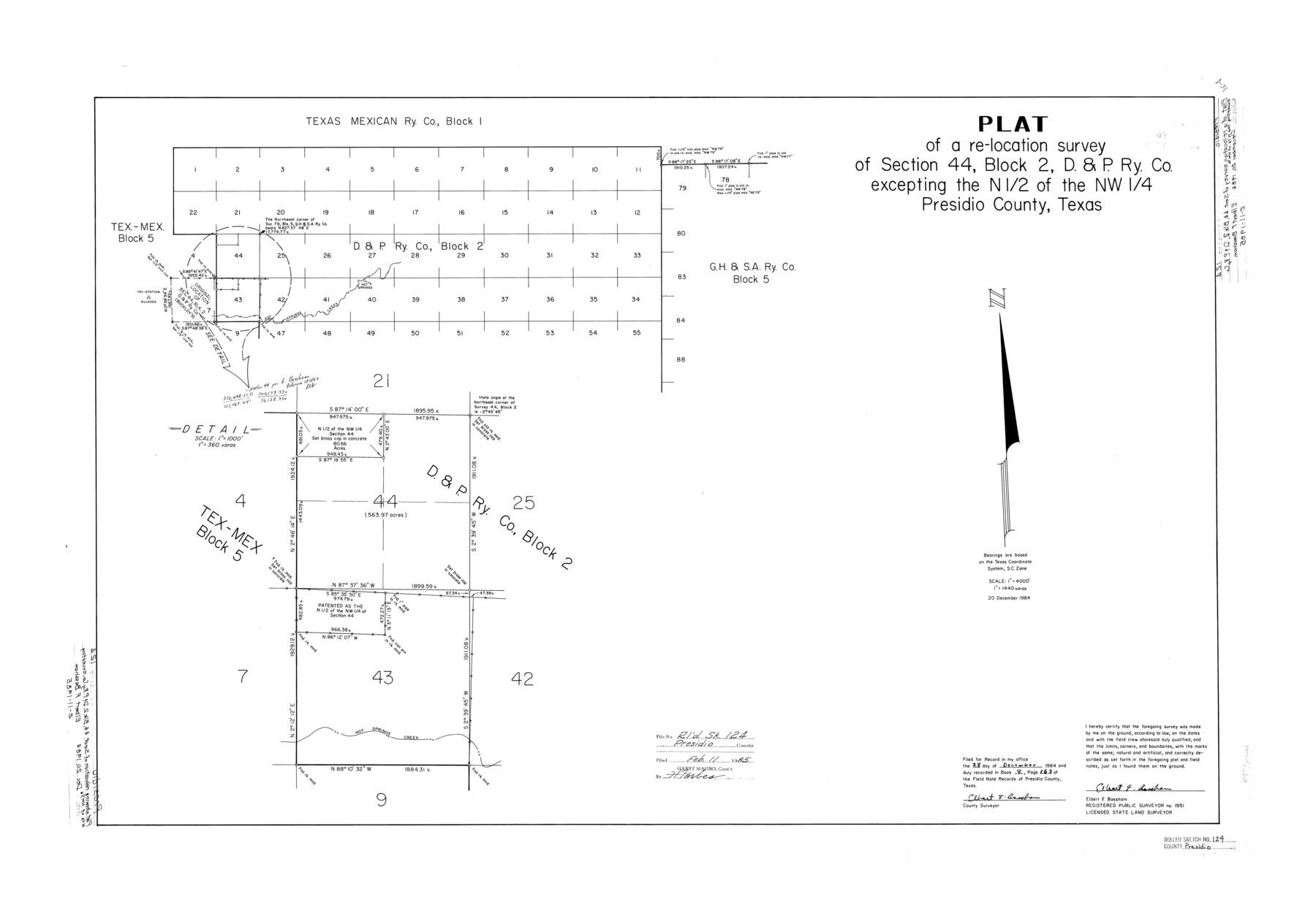
Presidio County Rolled Sketch 124
Plat of a re-location survey of section 44, Block 2, D. & P. Ry. Co. excepting the N 1/2 of the NW 1/4, Presidio County, Texas
-
Map/Doc
7396
-
Collection
General Map Collection
-
Object Dates
1984/12/20 (Creation Date)
1985/2/11 (File Date)
-
People and Organizations
Elbert F. Bassham (Surveyor/Engineer)
-
Counties
Presidio
-
Subjects
Surveying Rolled Sketch
-
Height x Width
27.9 x 39.8 inches
70.9 x 101.1 cm
-
Medium
mylar, print
-
Scale
1" = 1440 varas
Part of: General Map Collection
Harris County Working Sketch 72

Print $20.00
- Digital $50.00
Harris County Working Sketch 72
1958
Size 24.9 x 43.6 inches
Map/Doc 65964
Potter County

Print $20.00
- Digital $50.00
Potter County
1909
Size 45.3 x 40.6 inches
Map/Doc 16790
![78444, [Webb County], General Map Collection](https://historictexasmaps.com/wmedia_w700/maps/78444.tif.jpg)
Shelby County Sketch File 28

Print $4.00
- Digital $50.00
Shelby County Sketch File 28
Size 6.2 x 7.9 inches
Map/Doc 36664
Irion County Sketch File 19

Print $4.00
- Digital $50.00
Irion County Sketch File 19
1858
Size 8.1 x 9.9 inches
Map/Doc 82532
Crane County Rolled Sketch 21

Print $20.00
- Digital $50.00
Crane County Rolled Sketch 21
1988
Size 42.5 x 36.6 inches
Map/Doc 8685
Sketch of Robertson Co., Tehuacana Creek

Print $3.00
- Digital $50.00
Sketch of Robertson Co., Tehuacana Creek
1846
Size 10.3 x 16.4 inches
Map/Doc 264
Map of the country in the vicinity of San Antonio de Bexar reduced in part from the county map of Bexar with additions by J. Edmd. Blake, 1st Lieut Topl. Engs.

Print $20.00
- Digital $50.00
Map of the country in the vicinity of San Antonio de Bexar reduced in part from the county map of Bexar with additions by J. Edmd. Blake, 1st Lieut Topl. Engs.
1845
Size 18.3 x 26.1 inches
Map/Doc 72720
Duval County Rolled Sketch 20

Print $20.00
- Digital $50.00
Duval County Rolled Sketch 20
Size 33.2 x 42.0 inches
Map/Doc 8811
Motley County Sketch File 9 (N)

Print $10.00
- Digital $50.00
Motley County Sketch File 9 (N)
1902
Size 11.1 x 8.6 inches
Map/Doc 32019
Presidio County Rolled Sketch 85

Print $20.00
- Digital $50.00
Presidio County Rolled Sketch 85
1930
Size 28.3 x 27.3 inches
Map/Doc 7371
Flight Mission No. CRC-5R, Frame 16, Chambers County

Print $20.00
- Digital $50.00
Flight Mission No. CRC-5R, Frame 16, Chambers County
1956
Size 18.6 x 22.4 inches
Map/Doc 84938
You may also like
[International & Great Northern Railroad, from Troupe to Overton]
![64388, [International & Great Northern Railroad, from Troupe to Overton], General Map Collection](https://historictexasmaps.com/wmedia_w700/maps/64388.tif.jpg)
Print $20.00
- Digital $50.00
[International & Great Northern Railroad, from Troupe to Overton]
1903
Size 25.1 x 38.4 inches
Map/Doc 64388
Blanco County Working Sketch 28

Print $20.00
- Digital $50.00
Blanco County Working Sketch 28
1969
Size 33.7 x 37.7 inches
Map/Doc 67388
Liberty County Sketch File 21

Print $5.00
- Digital $50.00
Liberty County Sketch File 21
1858
Size 7.9 x 13.0 inches
Map/Doc 29928
[Right of Way & Track Map, The Texas & Pacific Ry. Co. Main Line]
![64661, [Right of Way & Track Map, The Texas & Pacific Ry. Co. Main Line], General Map Collection](https://historictexasmaps.com/wmedia_w700/maps/64661.tif.jpg)
Print $20.00
- Digital $50.00
[Right of Way & Track Map, The Texas & Pacific Ry. Co. Main Line]
Size 11.0 x 18.6 inches
Map/Doc 64661
Nueces County Sketch File 12c

Print $11.00
- Digital $50.00
Nueces County Sketch File 12c
1889
Size 12.6 x 8.2 inches
Map/Doc 32534
Cochran County Boundary File 5

Print $12.00
- Digital $50.00
Cochran County Boundary File 5
Size 4.2 x 8.8 inches
Map/Doc 51556
Montgomery County Sketch File 3

Print $12.00
- Digital $50.00
Montgomery County Sketch File 3
1846
Size 4.5 x 8.3 inches
Map/Doc 31770
Edwards County Working Sketch 53

Print $40.00
- Digital $50.00
Edwards County Working Sketch 53
1951
Size 40.8 x 48.5 inches
Map/Doc 68929
Bexar County Sketch File 34

Print $23.00
- Digital $50.00
Bexar County Sketch File 34
1872
Size 12.2 x 12.5 inches
Map/Doc 14498
Map of Bandera County

Print $40.00
- Digital $50.00
Map of Bandera County
1885
Size 33.5 x 64.7 inches
Map/Doc 4771
Andrews County Rolled Sketch 13

Print $20.00
- Digital $50.00
Andrews County Rolled Sketch 13
1934
Size 38.3 x 26.2 inches
Map/Doc 77163
Flight Mission No. CZW-1R, Frame 165, Hardeman County

Print $20.00
- Digital $50.00
Flight Mission No. CZW-1R, Frame 165, Hardeman County
1956
Size 18.7 x 22.4 inches
Map/Doc 85236