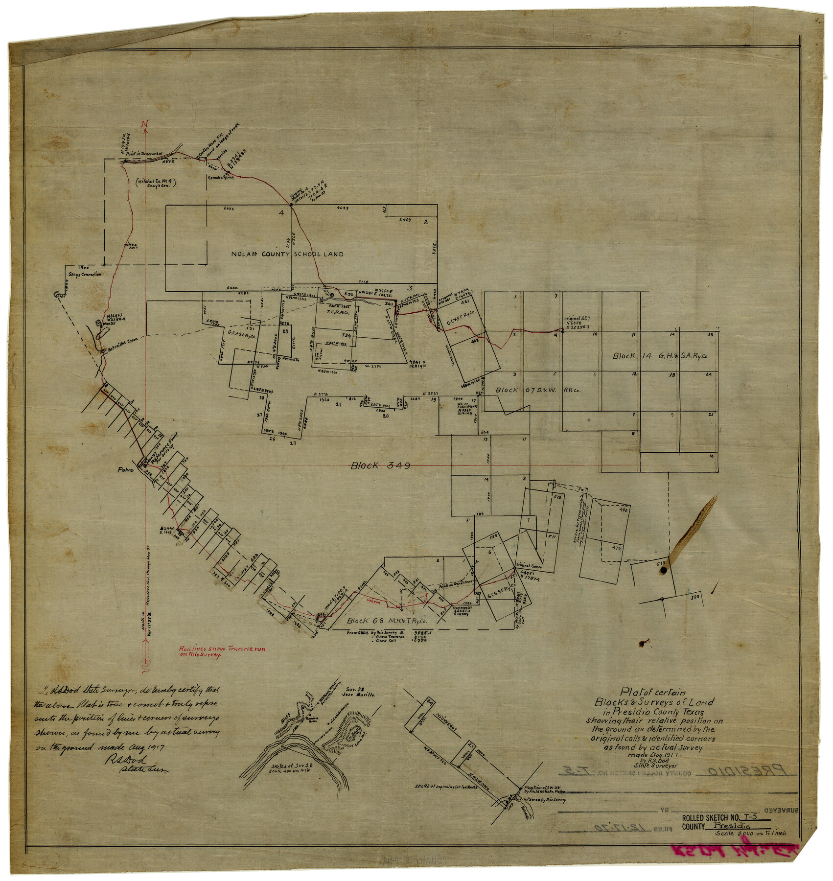
Presidio County Rolled Sketch T-5
Plat of certain Blocks & surveys of land in Presidio County, Texas showing their relative position on the ground as determined by the original calls & identified corners as found by actual survey
-
Map/Doc
7419
-
Collection
General Map Collection
-
Object Dates
8/1917 (Creation Date)
12/17/1970 (File Date)
-
People and Organizations
R.S. Dod (Surveyor/Engineer)
-
Counties
Presidio
-
Subjects
Surveying Rolled Sketch
-
Height x Width
21.2 x 20.4 inches
53.9 x 51.8 cm
-
Medium
linen, manuscript
-
Scale
1" = 2000 varas
Part of: General Map Collection
Flight Mission No. CGI-1N, Frame 136, Cameron County

Print $20.00
- Digital $50.00
Flight Mission No. CGI-1N, Frame 136, Cameron County
1955
Size 17.2 x 18.5 inches
Map/Doc 84492

Bell County Sketch File 34

Print $40.00
- Digital $50.00
Bell County Sketch File 34
Size 15.4 x 13.4 inches
Map/Doc 14455
Kimble County Working Sketch 76

Print $20.00
- Digital $50.00
Kimble County Working Sketch 76
1969
Size 27.7 x 41.0 inches
Map/Doc 70144
Starr County Working Sketch 2

Print $20.00
- Digital $50.00
Starr County Working Sketch 2
1916
Size 12.0 x 37.0 inches
Map/Doc 63918
Martin County Working Sketch 14

Print $20.00
- Digital $50.00
Martin County Working Sketch 14
1972
Size 39.6 x 22.6 inches
Map/Doc 70832
Crane County Working Sketch 8

Print $20.00
- Digital $50.00
Crane County Working Sketch 8
1929
Size 33.2 x 28.4 inches
Map/Doc 68285
Ochiltree County

Print $20.00
- Digital $50.00
Ochiltree County
1908
Size 42.6 x 37.5 inches
Map/Doc 66958
Anderson County Rolled Sketch 6

Print $40.00
- Digital $50.00
Anderson County Rolled Sketch 6
Size 93.3 x 43.5 inches
Map/Doc 81901
Pecos County Working Sketch 28

Print $20.00
- Digital $50.00
Pecos County Working Sketch 28
1935
Size 27.9 x 29.2 inches
Map/Doc 71500
Texas Gulf Coast Map from the Sabine River to the Rio Grande as subdivided for mineral development

Print $20.00
- Digital $50.00
Texas Gulf Coast Map from the Sabine River to the Rio Grande as subdivided for mineral development
1948
Size 41.6 x 39.2 inches
Map/Doc 2904
Jim Hogg County Rolled Sketch 5

Print $20.00
- Digital $50.00
Jim Hogg County Rolled Sketch 5
1943
Size 19.9 x 24.1 inches
Map/Doc 6441
You may also like
Map of Hidalgo County

Print $20.00
- Digital $50.00
Map of Hidalgo County
1880
Size 45.3 x 25.1 inches
Map/Doc 3667
[R. M. Thompson Block T2 and John H. Stephens Block S2 Conflict]
![91056, [R. M. Thompson Block T2 and John H. Stephens Block S2 Conflict], Twichell Survey Records](https://historictexasmaps.com/wmedia_w700/maps/91056-1.tif.jpg)
Print $20.00
- Digital $50.00
[R. M. Thompson Block T2 and John H. Stephens Block S2 Conflict]
Size 20.9 x 30.6 inches
Map/Doc 91056
Bell County Rolled Sketch 2

Print $20.00
- Digital $50.00
Bell County Rolled Sketch 2
1954
Size 27.0 x 28.0 inches
Map/Doc 5133
Galveston County Sketch File 3

Print $8.00
- Digital $50.00
Galveston County Sketch File 3
1847
Size 13.3 x 8.2 inches
Map/Doc 23352

Hardin County Sketch File 59

Print $6.00
- Digital $50.00
Hardin County Sketch File 59
Size 16.8 x 11.6 inches
Map/Doc 25233
Harris County Sketch File 102

Print $163.00
- Digital $50.00
Harris County Sketch File 102
1985
Size 11.4 x 8.9 inches
Map/Doc 25915
Somervell County Working Sketch 2

Print $20.00
- Digital $50.00
Somervell County Working Sketch 2
1951
Size 22.4 x 23.8 inches
Map/Doc 63906
Lampasas County Working Sketch 2

Print $20.00
- Digital $50.00
Lampasas County Working Sketch 2
1936
Size 14.4 x 18.0 inches
Map/Doc 70279
Flight Mission No. CLL-1N, Frame 83, Willacy County

Print $20.00
- Digital $50.00
Flight Mission No. CLL-1N, Frame 83, Willacy County
1954
Size 18.3 x 22.0 inches
Map/Doc 87029
Aransas County Rolled Sketch 34

Print $42.00
- Digital $50.00
Aransas County Rolled Sketch 34
2004
Size 24.5 x 36.5 inches
Map/Doc 83637
Nueces County Rolled Sketch 62

Print $20.00
- Digital $50.00
Nueces County Rolled Sketch 62
1977
Size 25.0 x 33.3 inches
Map/Doc 6908