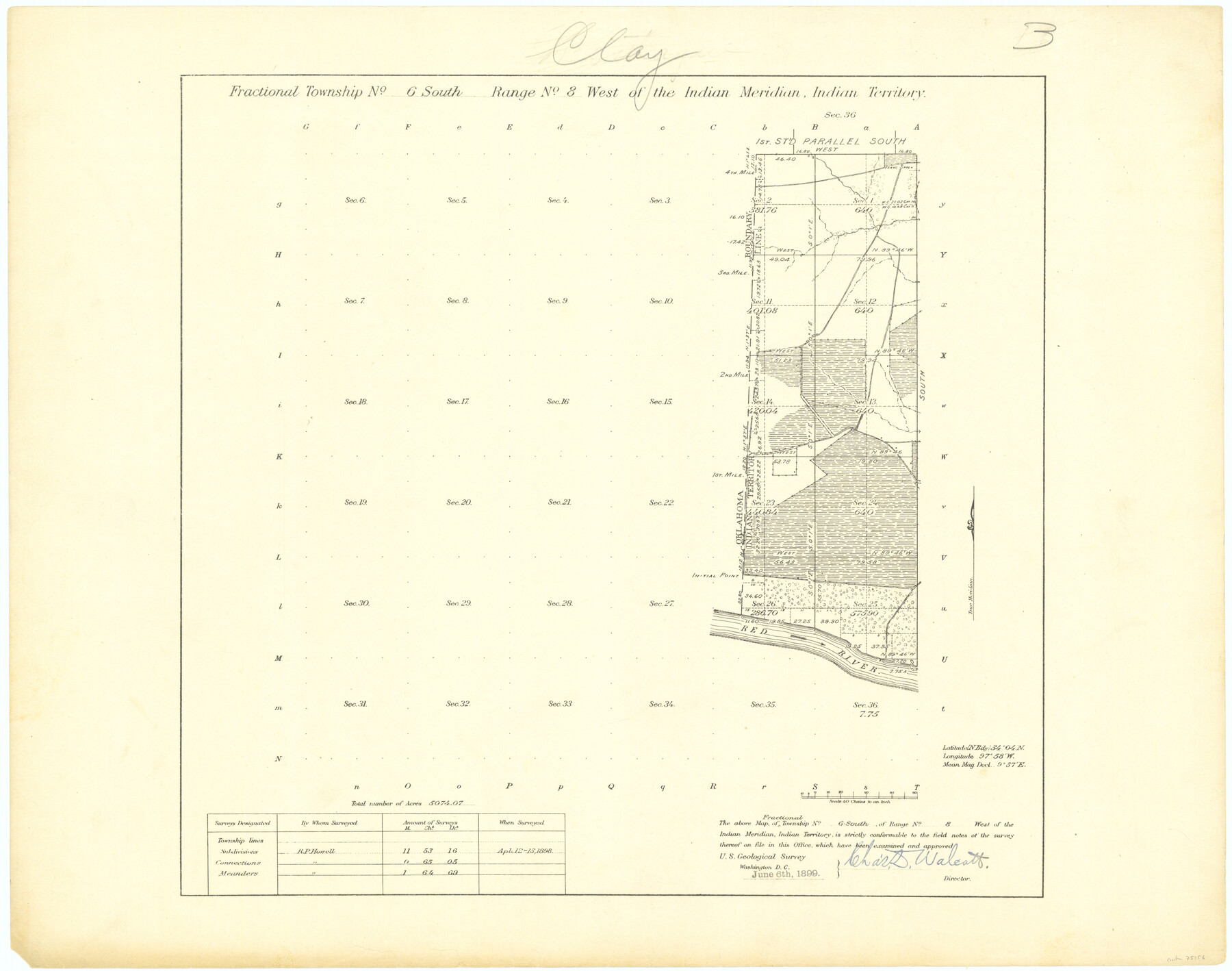
Fractional Township No. 6 South Range No. 8 West of the Indian Meridian, Indian Territory
-
Map/Doc
75156
-
Collection
General Map Collection
-
Object Dates
1898/4/13 (Creation Date)
-
Subjects
Texas Boundaries
-
Height x Width
19.2 x 24.4 inches
48.8 x 62.0 cm
Part of: General Map Collection
Kendall County Rolled Sketch 6

Print $20.00
- Digital $50.00
Kendall County Rolled Sketch 6
Size 29.6 x 39.4 inches
Map/Doc 6459
Fort Bend County Working Sketch 23

Print $20.00
- Digital $50.00
Fort Bend County Working Sketch 23
1978
Size 37.2 x 29.8 inches
Map/Doc 69229
Phelps & Ensign's Travellers' Guide, and Map of the United States containing the roads, distances, steam boat and canal routes & c.

Print $20.00
- Digital $50.00
Phelps & Ensign's Travellers' Guide, and Map of the United States containing the roads, distances, steam boat and canal routes & c.
1841
Size 28.8 x 33.9 inches
Map/Doc 96875
Flight Mission No. BRA-17M, Frame 11, Jefferson County

Print $20.00
- Digital $50.00
Flight Mission No. BRA-17M, Frame 11, Jefferson County
1953
Size 18.4 x 22.2 inches
Map/Doc 85792
Northeast Part of Webb County

Print $40.00
- Digital $50.00
Northeast Part of Webb County
1986
Size 38.0 x 49.2 inches
Map/Doc 73318
Ector County Working Sketch 32

Print $20.00
- Digital $50.00
Ector County Working Sketch 32
1981
Size 26.2 x 17.0 inches
Map/Doc 68875
Pecos County Working Sketch 130

Print $20.00
- Digital $50.00
Pecos County Working Sketch 130
1976
Size 27.6 x 36.5 inches
Map/Doc 71604
Crane County Sketch File 9

Print $20.00
- Digital $50.00
Crane County Sketch File 9
1926
Size 21.7 x 34.1 inches
Map/Doc 11208
Map of Kinney County

Print $20.00
- Digital $50.00
Map of Kinney County
1863
Size 31.4 x 29.7 inches
Map/Doc 3774
San Patricio County Working Sketch 4

Print $20.00
- Digital $50.00
San Patricio County Working Sketch 4
1924
Size 20.8 x 23.6 inches
Map/Doc 63766

Erath County Working Sketch 30

Print $20.00
- Digital $50.00
Erath County Working Sketch 30
1970
Size 23.2 x 23.6 inches
Map/Doc 69111
You may also like
Jack County Sketch File 19

Print $4.00
- Digital $50.00
Jack County Sketch File 19
1878
Size 10.4 x 8.3 inches
Map/Doc 27559
King County Rolled Sketch 11

Print $20.00
- Digital $50.00
King County Rolled Sketch 11
1955
Size 40.2 x 46.6 inches
Map/Doc 9351
Nueces County Rolled Sketch 113A

Print $20.00
- Digital $50.00
Nueces County Rolled Sketch 113A
1972
Size 19.1 x 24.4 inches
Map/Doc 7121
Madison County Working Sketch 9

Print $20.00
- Digital $50.00
Madison County Working Sketch 9
1982
Size 15.7 x 21.1 inches
Map/Doc 70771
Flight Mission No. DAG-24K, Frame 44, Matagorda County

Print $20.00
- Digital $50.00
Flight Mission No. DAG-24K, Frame 44, Matagorda County
1953
Size 16.0 x 15.9 inches
Map/Doc 86531

Map of Galveston, Turtle & East Bays & portions of the Gulf of Mexico in Chambers & Galveston Counties, Texas showing subdivision for mineral development

Print $40.00
- Digital $50.00
Map of Galveston, Turtle & East Bays & portions of the Gulf of Mexico in Chambers & Galveston Counties, Texas showing subdivision for mineral development
Size 48.6 x 56.4 inches
Map/Doc 65803
Midland County Sketch File 5

Print $2.00
- Digital $50.00
Midland County Sketch File 5
Size 8.4 x 3.5 inches
Map/Doc 31575
Guadalupe County

Print $20.00
- Digital $50.00
Guadalupe County
1854
Size 25.0 x 21.1 inches
Map/Doc 3609
Surveys along the Leona River in the County of Bexar not yet connected with other surveys

Print $20.00
- Digital $50.00
Surveys along the Leona River in the County of Bexar not yet connected with other surveys
Size 21.8 x 28.7 inches
Map/Doc 70
Map A [showing surveys along river and in vicinity of Archer County School Land League 3]
![89751, Map A [showing surveys along river and in vicinity of Archer County School Land League 3], Twichell Survey Records](https://historictexasmaps.com/wmedia_w700/maps/89751-1.tif.jpg)
Print $20.00
- Digital $50.00
Map A [showing surveys along river and in vicinity of Archer County School Land League 3]
Size 42.3 x 38.0 inches
Map/Doc 89751
Henderson County Working Sketch 14

Print $20.00
- Digital $50.00
Henderson County Working Sketch 14
1934
Size 26.2 x 22.9 inches
Map/Doc 66147