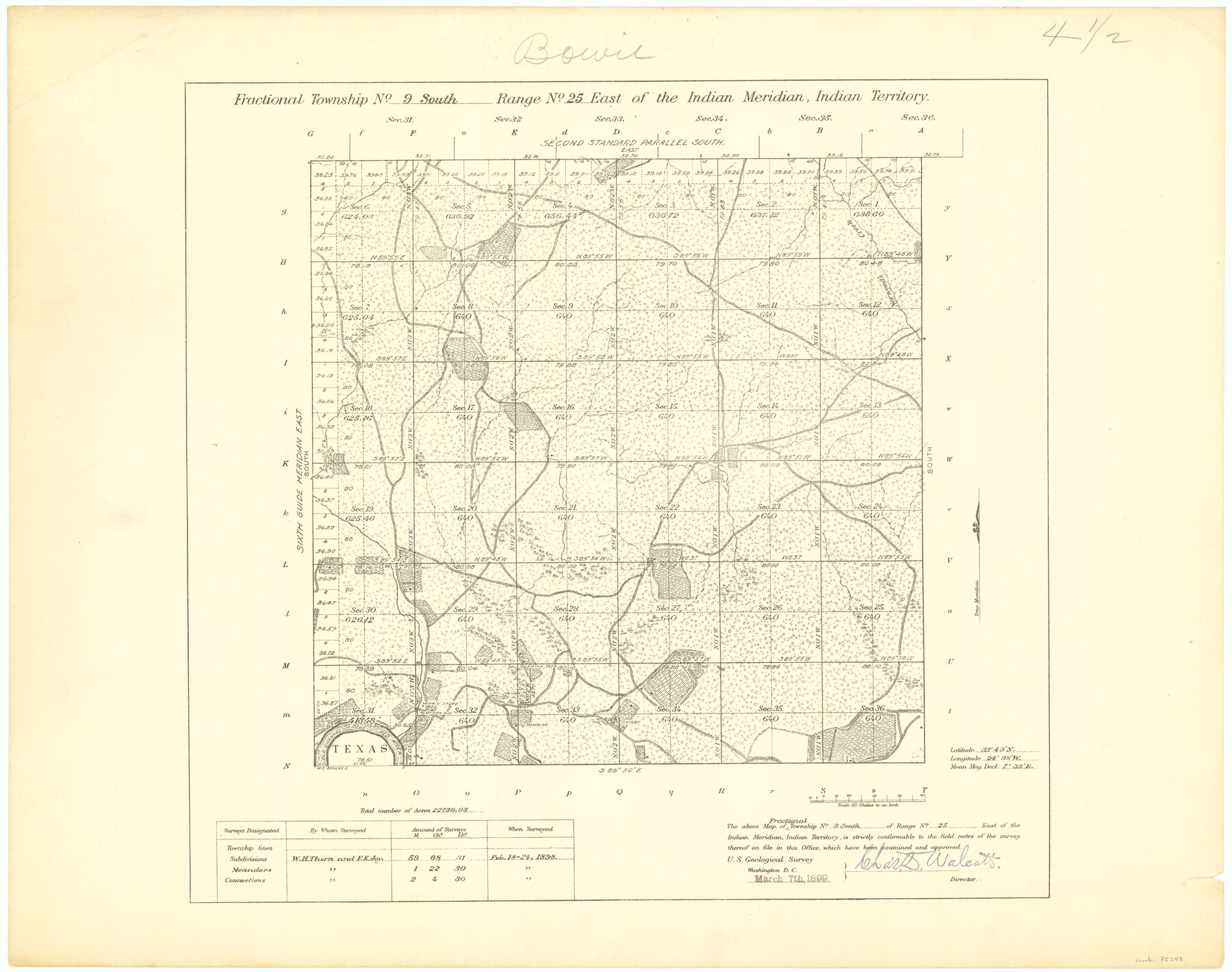
Fractional Township No. 9 South Range No. 25 East of the Indian Meridian, Indian Territory
-
Map/Doc
75243
-
Collection
General Map Collection
-
Object Dates
1898/2/24 (Creation Date)
-
Subjects
Texas Boundaries
-
Height x Width
19.2 x 24.3 inches
48.8 x 61.7 cm
Part of: General Map Collection
San Patricio County Working Sketch 5

Print $20.00
- Digital $50.00
San Patricio County Working Sketch 5
1934
Size 31.6 x 35.9 inches
Map/Doc 63767
Val Verde County Rolled Sketch 69A

Print $40.00
- Digital $50.00
Val Verde County Rolled Sketch 69A
1942
Size 11.0 x 139.1 inches
Map/Doc 10086
Gregg County Working Sketch 14

Print $20.00
- Digital $50.00
Gregg County Working Sketch 14
1941
Size 29.7 x 39.5 inches
Map/Doc 63281
Red River County Rolled Sketch 11

Print $40.00
- Digital $50.00
Red River County Rolled Sketch 11
2006
Size 36.8 x 48.6 inches
Map/Doc 88614
San Augustine County Working Sketch 5

Print $20.00
- Digital $50.00
San Augustine County Working Sketch 5
1935
Size 39.0 x 37.4 inches
Map/Doc 63692
Dimmit County Sketch File 39

Print $8.00
- Digital $50.00
Dimmit County Sketch File 39
1901
Size 14.6 x 9.0 inches
Map/Doc 21165
Liberty County Working Sketch 87

Print $20.00
- Digital $50.00
Liberty County Working Sketch 87
1989
Size 37.4 x 32.5 inches
Map/Doc 70547
Presidio County Working Sketch 144

Print $20.00
- Digital $50.00
Presidio County Working Sketch 144
1990
Size 20.4 x 26.6 inches
Map/Doc 71822
Baylor County Sketch File 8

Print $44.00
- Digital $50.00
Baylor County Sketch File 8
1887
Size 13.0 x 8.6 inches
Map/Doc 14137
Childress Co.

Print $20.00
- Digital $50.00
Childress Co.
1978
Size 47.3 x 36.0 inches
Map/Doc 95454

Hutchinson County

Print $20.00
- Digital $50.00
Hutchinson County
1884
Size 20.8 x 19.0 inches
Map/Doc 3694
You may also like
Moore County Rolled Sketch 16A

Print $20.00
- Digital $50.00
Moore County Rolled Sketch 16A
1982
Size 21.1 x 33.4 inches
Map/Doc 6834
McClennan [sic] County, Texas
![577, McClennan [sic] County, Texas, Maddox Collection](https://historictexasmaps.com/wmedia_w700/maps/577.tif.jpg)
Print $20.00
- Digital $50.00
McClennan [sic] County, Texas
1880
Size 23.5 x 26.7 inches
Map/Doc 577
Parker County Sketch File 45

Print $10.00
- Digital $50.00
Parker County Sketch File 45
1935
Size 11.0 x 8.5 inches
Map/Doc 33610
Bailey County Working Sketch Graphic Index

Print $20.00
- Digital $50.00
Bailey County Working Sketch Graphic Index
1956
Size 47.7 x 30.5 inches
Map/Doc 76460
[Southeast part of County]
![89956, [Southeast part of County], Twichell Survey Records](https://historictexasmaps.com/wmedia_w700/maps/89956-2.tif.jpg)
Print $40.00
- Digital $50.00
[Southeast part of County]
Size 37.1 x 48.2 inches
Map/Doc 89956
Concho County Rolled Sketch 11

Print $20.00
- Digital $50.00
Concho County Rolled Sketch 11
1957
Size 29.5 x 34.5 inches
Map/Doc 5569
Wichita County Working Sketch 14

Print $20.00
- Digital $50.00
Wichita County Working Sketch 14
1922
Size 20.8 x 42.1 inches
Map/Doc 72524
Map of Wharton County

Print $20.00
- Digital $50.00
Map of Wharton County
1871
Size 22.0 x 22.9 inches
Map/Doc 4642
Crockett County Working Sketch 27

Print $20.00
- Digital $50.00
Crockett County Working Sketch 27
1923
Size 29.4 x 27.2 inches
Map/Doc 68360
United States - Gulf Coast - Galveston to Rio Grande

Print $20.00
- Digital $50.00
United States - Gulf Coast - Galveston to Rio Grande
1941
Size 26.7 x 18.5 inches
Map/Doc 72751

The Republic County of Harris. May 15, 1838

Print $20.00
The Republic County of Harris. May 15, 1838
2020
Size 17.7 x 21.7 inches
Map/Doc 96163