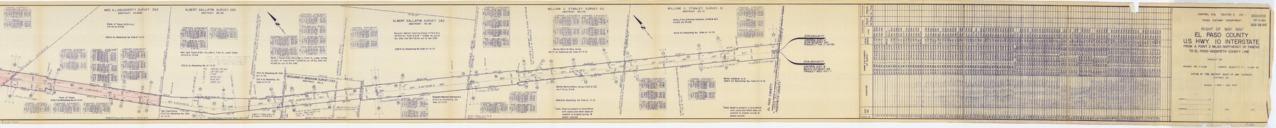
El Paso County Rolled Sketch 49
Right of Way map, El Paso County U.S. Hwy 10 Interstate from a point 2 miles northeast of Fabens to El Paso-Hudspeth County line
-
Map/Doc
76061
-
Collection
General Map Collection
-
Object Dates
1958/9/28 (File Date)
-
People and Organizations
Texas Highway Department (Publisher)
-
Counties
El Paso
-
Subjects
Surveying Rolled Sketch
-
Height x Width
10.5 x 104.9 inches
26.7 x 266.4 cm
-
Medium
blueprint/diazo
-
Scale
1" = 400 feet
-
Comments
Segment 1. See 8875 for segment 2.
Related maps
El Paso County Rolled Sketch 49

Print $40.00
- Digital $50.00
El Paso County Rolled Sketch 49
Size 10.5 x 99.9 inches
Map/Doc 8875
Part of: General Map Collection
Hale County Sketch File 3a

Print $20.00
- Digital $50.00
Hale County Sketch File 3a
Size 21.1 x 14.6 inches
Map/Doc 11593

Sterling County Rolled Sketch 14

Print $20.00
- Digital $50.00
Sterling County Rolled Sketch 14
Size 22.3 x 26.6 inches
Map/Doc 7848
Tom Green County Rolled Sketch 17

Print $40.00
- Digital $50.00
Tom Green County Rolled Sketch 17
Size 49.2 x 37.8 inches
Map/Doc 10005
Flight Mission No. CRC-2R, Frame 114, Chambers County

Print $20.00
- Digital $50.00
Flight Mission No. CRC-2R, Frame 114, Chambers County
1956
Size 18.5 x 22.4 inches
Map/Doc 84741
Montague County Sketch File 12

Print $4.00
- Digital $50.00
Montague County Sketch File 12
Size 11.4 x 8.2 inches
Map/Doc 31736
Newton County Rolled Sketch 21

Print $40.00
- Digital $50.00
Newton County Rolled Sketch 21
1957
Size 29.9 x 52.5 inches
Map/Doc 9582
Limestone County Working Sketch 5

Print $20.00
- Digital $50.00
Limestone County Working Sketch 5
1922
Size 21.2 x 28.9 inches
Map/Doc 70555
Leon County Sketch File 25

Print $26.00
- Digital $50.00
Leon County Sketch File 25
Size 11.3 x 8.5 inches
Map/Doc 29788
Cooke County Sketch File 5

Print $4.00
- Digital $50.00
Cooke County Sketch File 5
1857
Size 12.7 x 8.2 inches
Map/Doc 19226
McCulloch County Sketch File 14

Print $8.00
- Digital $50.00
McCulloch County Sketch File 14
1990
Size 11.2 x 8.7 inches
Map/Doc 31203
Dallas County Boundary File 6c

Print $4.00
- Digital $50.00
Dallas County Boundary File 6c
Size 14.0 x 8.6 inches
Map/Doc 52227
You may also like
[Surveys in Austin's Colony]
![78, [Surveys in Austin's Colony], General Map Collection](https://historictexasmaps.com/wmedia_w700/maps/78.tif.jpg)
Print $20.00
- Digital $50.00
[Surveys in Austin's Colony]
Size 16.0 x 13.0 inches
Map/Doc 78
Jasper County Working Sketch 2

Print $20.00
- Digital $50.00
Jasper County Working Sketch 2
Size 18.6 x 22.5 inches
Map/Doc 66464
Oldham County Rolled Sketch 7

Print $20.00
- Digital $50.00
Oldham County Rolled Sketch 7
Size 36.2 x 27.5 inches
Map/Doc 7173
Map of Nacogdoches County

Print $20.00
- Digital $50.00
Map of Nacogdoches County
1881
Size 24.0 x 21.4 inches
Map/Doc 4607
[Sketch for Mineral Application 26501 - Sabine River, T. A. Oldhausen]
![2843, [Sketch for Mineral Application 26501 - Sabine River, T. A. Oldhausen], General Map Collection](https://historictexasmaps.com/wmedia_w700/maps/2843.tif.jpg)
Print $20.00
- Digital $50.00
[Sketch for Mineral Application 26501 - Sabine River, T. A. Oldhausen]
1931
Size 23.8 x 36.2 inches
Map/Doc 2843
Menard County Boundary File 2a

Print $80.00
- Digital $50.00
Menard County Boundary File 2a
Size 36.4 x 12.2 inches
Map/Doc 57065
Foard County Working Sketch 1

Print $20.00
- Digital $50.00
Foard County Working Sketch 1
1899
Size 20.5 x 22.8 inches
Map/Doc 69191
Anderson County Boundary File 6

Print $9.00
- Digital $50.00
Anderson County Boundary File 6
Size 14.3 x 8.7 inches
Map/Doc 49747
Williamson County Working Sketch 4

Print $20.00
- Digital $50.00
Williamson County Working Sketch 4
1919
Size 23.7 x 19.4 inches
Map/Doc 72564
![92955, [Block 4X], Twichell Survey Records](https://historictexasmaps.com/wmedia_w700/maps/92955-1.tif.jpg)
Flight Mission No. CRE-2R, Frame 90, Jackson County

Print $20.00
- Digital $50.00
Flight Mission No. CRE-2R, Frame 90, Jackson County
1956
Size 16.0 x 15.8 inches
Map/Doc 85362
McCulloch County Working Sketch 19

Print $20.00
- Digital $50.00
McCulloch County Working Sketch 19
2010
Size 32.6 x 27.0 inches
Map/Doc 89260